


Summary
Santa Rosa (Spanish pronunciation: [ˈsanta ˈrosa]) is a city in the Argentine Pampas (lowlands), and the capital of La Pampa Province, Argentina. It lies on the east of the province, on the shore of the Don Tomás Lagoon, at the intersection of National Routes 5 and 35. The city (94,340) and its surroundings hold 102,610 inhabitants (2001 census [INDEC]),Census-ar 2.010 hold 124.101 inhabitants the capital y Toay around a third of the population of the province. Its current mayor is Luciano di Nápoli. Founded in 1892 by Tomás Mason, Santa Rosa did not develop into a relatively important agricultural centre until the second half of the 20th century. It is still one of the smallest provincial capitals of the country after Patagonian Rawson, Ushuaia and Viedma.
Santa Rosa | |
|---|---|
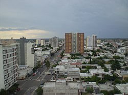 Panoramic of Santa Rosa | |
 Santa Rosa  Santa Rosa | |
| Coordinates: 36°37′0″S 64°17′0″W / 36.61667°S 64.28333°W | |
| Country | |
| Province | |
| Department | Capital |
| Founded | 22 April 1892 |
| Government | |
| • Intendant | Luciano di Nápoli |
| Area | |
| • City | 1,500 km2 (600 sq mi) |
| Elevation | 175 m (574 ft) |
| Population (2010 census) | |
| • Urban | 102,880 |
| Time zone | UTC−3 (ART) |
| Postal code | L6300 |
| Phone code | +54 2954 |
| Website | (in Spanish) www.santarosa.gov.ar |
City sights include the Fitte neighbourhood (1930), the monument to San Martín, the Palace of Justice, the Teatro Español Theatre (1908), the Provincial Art Museum (with paintings by Raúl Soldi, Antonio Berni, Quinquela Martín and other important Argentine painters) and the Provincial Natural History Museum.
The Santa Rosa Airport (IATA: RSA, ICAO: SAZR) is located 2 kilometres from Santa Rosa on Route 35, and serves regular flights to Buenos Aires.
Near Santa Rosa is the city of Toay, together both cities form the Gran Santa Rosa metropolitan area.
Geography edit

Santa Rosa was founded on the western edge of the Argentine Pampas, in the range of contact of two different natural environments: the end of the plain and the beginning of the land of the Pampas broken valley.
The town occupies part of a centripetal basin having their base in Don Tomás Lagoon, where rainwater drains from the surrounding area. The floor area lies west of it, in hilly terrain where the highest elevations are in the east, with two small plateaus located 200 meters. This high turnover is also observed north, with heights up to 195 meters. From here the terrain descends to the west and south, with slopes that are steep in some areas, since more than 3%. The southwest sector is lower and less undulating area, descending to 167 masl.
Climate edit
Santa Rosa has a humid subtropical climate (Cfa/Cwa, according to the Köppen climate classification), with warm to hot summers and chilly, dry winters. The highest temperature recorded was 45.7 °C (114 °F) on January 6, 1955 while the record low is −12.7 °C (9 °F) on June 13, 1967.[1]
| Climate data for Santa Rosa (1991–2020, extremes 1902–present) | |||||||||||||
|---|---|---|---|---|---|---|---|---|---|---|---|---|---|
| Month | Jan | Feb | Mar | Apr | May | Jun | Jul | Aug | Sep | Oct | Nov | Dec | Year |
| Record high °C (°F) | 45.7 (114.3) |
42.2 (108.0) |
39.7 (103.5) |
36.5 (97.7) |
31.8 (89.2) |
27.1 (80.8) |
27.8 (82.0) |
34.4 (93.9) |
35.2 (95.4) |
38.4 (101.1) |
39.9 (103.8) |
42.8 (109.0) |
45.7 (114.3) |
| Mean daily maximum °C (°F) | 31.5 (88.7) |
29.9 (85.8) |
27.3 (81.1) |
22.7 (72.9) |
18.2 (64.8) |
15.1 (59.2) |
14.5 (58.1) |
17.6 (63.7) |
20.3 (68.5) |
23.0 (73.4) |
27.1 (80.8) |
30.3 (86.5) |
23.1 (73.6) |
| Daily mean °C (°F) | 23.8 (74.8) |
22.2 (72.0) |
19.7 (67.5) |
15.2 (59.4) |
11.3 (52.3) |
8.1 (46.6) |
7.4 (45.3) |
9.6 (49.3) |
12.5 (54.5) |
15.8 (60.4) |
19.6 (67.3) |
22.7 (72.9) |
15.7 (60.3) |
| Mean daily minimum °C (°F) | 16.5 (61.7) |
15.2 (59.4) |
13.4 (56.1) |
9.5 (49.1) |
6.1 (43.0) |
3.0 (37.4) |
2.1 (35.8) |
3.5 (38.3) |
5.9 (42.6) |
9.2 (48.6) |
12.4 (54.3) |
15.2 (59.4) |
9.3 (48.7) |
| Record low °C (°F) | 0.9 (33.6) |
2.3 (36.1) |
−3.7 (25.3) |
−7.0 (19.4) |
−8.6 (16.5) |
−12.7 (9.1) |
−12.3 (9.9) |
−10.0 (14.0) |
−8.8 (16.2) |
−4.3 (24.3) |
−1.2 (29.8) |
2.0 (35.6) |
−12.7 (9.1) |
| Average precipitation mm (inches) | 95.3 (3.75) |
88.3 (3.48) |
99.0 (3.90) |
63.8 (2.51) |
32.1 (1.26) |
17.3 (0.68) |
18.8 (0.74) |
26.9 (1.06) |
49.7 (1.96) |
90.2 (3.55) |
75.9 (2.99) |
96.1 (3.78) |
753.4 (29.66) |
| Average precipitation days (≥ 0.1 mm) | 8.3 | 7.2 | 7.2 | 6.1 | 4.7 | 4.2 | 4.3 | 3.5 | 5.3 | 8.3 | 7.6 | 8.0 | 74.7 |
| Average snowy days | 0.0 | 0.0 | 0.0 | 0.0 | 0.0 | 0.0 | 0.1 | 0.1 | 0.0 | 0.0 | 0.0 | 0.0 | 0.1 |
| Average relative humidity (%) | 57.1 | 62.9 | 68.4 | 70.7 | 75.8 | 73.6 | 70.2 | 62.7 | 60.0 | 62.1 | 56.5 | 53.3 | 64.4 |
| Mean monthly sunshine hours | 306.9 | 248.6 | 226.3 | 183.0 | 151.9 | 132.0 | 145.7 | 179.8 | 180.0 | 210.8 | 279.0 | 297.6 | 2,541.6 |
| Mean daily sunshine hours | 9.9 | 8.8 | 7.3 | 6.1 | 4.9 | 4.4 | 4.7 | 5.8 | 6.0 | 6.8 | 9.3 | 9.6 | 7.0 |
| Percent possible sunshine | 71 | 68 | 59 | 59 | 50 | 45 | 47 | 54 | 53 | 56 | 65 | 67 | 58 |
| Source 1: Servicio Meteorológico Nacional[2][3][4] | |||||||||||||
| Source 2: NOAA (percent sun 1961–1990)[5] Meteo Climat (record highs and lows),[1][6] | |||||||||||||
Sport edit
The city is home to football team, Club Atlético Santa Rosa, Club Atlético All Boys and Club Atlético Belgrano.
-
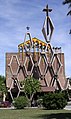 Church in Santa Rosa, Argentina.
 -
 Municipal Building, Santa Rosa, Argentina.
 -
 Monument to José de San Martín, Santa Rosa.


References edit
- ^ a b "Station Santa Rosa" (in French). Meteo Climat. Retrieved June 11, 2015.
- ^ "Estadísticas Climatológicas Normales - período 1991-2020" (in Spanish). Servicio Meteorológico Nacional. Retrieved 29 April 2023.
- ^ "Estadísticas Climatológicas Normales – período 1991–2020" (PDF) (in Spanish). Servicio Meteorológico Nacional. 2023. Archived from the original on 8 July 2023. Retrieved 1 August 2023.
- ^ "Clima en la Argentina: Guia Climática por Santa Rosa Aero". Caracterización: Estadísticas de largo plazo (in Spanish). Servicio Meteorológico Nacional. Retrieved 29 April 2023.
- ^ "Santa Rosa Aero Climate Normals 1961-1990". National Oceanic and Atmospheric Administration. Retrieved March 30, 2015.
- ^ "Santa Rosa Aerodrome (Argentina)". ogimet.com. OGIMET. 6 February 2024. Retrieved 9 February 2024.
External links edit
- Santa Rosa Municipality (Spanish)
- Department of Transportation
- Municipal information: Municipal Affairs Federal Institute (IFAM), Municipal Affairs Secretariat, Ministry of Interior, Argentina. (in Spanish)
- Tourism (English)