


Summary
Santo Tomas, officially the Municipality of Santo Tomas (Pangasinan: Baley na Santo Tomas; Ilocano: Ili ti Santo Tomas; Tagalog: Bayan ng Santo Tomas), is a 5th class municipality in the province of Pangasinan, Philippines. According to the 2020 census, it has a population of 14,878 people.[4]
Santo Tomas | |
|---|---|
| Municipality of Santo Tomas | |
 Downtown area | |
 Flag  Seal | |
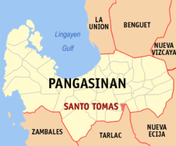 Map of Pangasinan with Santo Tomas highlighted | |
OpenStreetMap .mw-parser-output .locmap .od{position:absolute}.mw-parser-output .locmap .id{position:absolute;line-height:0}.mw-parser-output .locmap .l0{font-size:0;position:absolute}.mw-parser-output .locmap .pv{line-height:110%;position:absolute;text-align:center}.mw-parser-output .locmap .pl{line-height:110%;position:absolute;top:-0.75em;text-align:right}.mw-parser-output .locmap .pr{line-height:110%;position:absolute;top:-0.75em;text-align:left}.mw-parser-output .locmap .pv>div{display:inline;padding:1px}.mw-parser-output .locmap .pl>div{display:inline;padding:1px;float:right}.mw-parser-output .locmap .pr>div{display:inline;padding:1px;float:left}html.skin-theme-clientpref-night .mw-parser-output .od,html.skin-theme-clientpref-night .mw-parser-output .od .pv>div,html.skin-theme-clientpref-night .mw-parser-output .od .pl>div,html.skin-theme-clientpref-night .mw-parser-output .od .pr>div{background:#000;color:#fff}html.skin-theme-clientpref-night .mw-parser-output .locmap{filter:grayscale(0.6)}@media(prefers-color-scheme:dark){html.skin-theme-clientpref-os .mw-parser-output .locmap{filter:grayscale(0.6)}html.skin-theme-clientpref-os .mw-parser-output .od,html.skin-theme-clientpref-os .mw-parser-output .od .pv>div,html.skin-theme-clientpref-os .mw-parser-output .od .pl>div,html.skin-theme-clientpref-os .mw-parser-output .od .pr>div{background:#000;color:#fff}}  Santo Tomas Location within the Philippines | |
| Coordinates: 15°52′45″N 120°35′18″E / 15.8792°N 120.5883°E | |
| Country | Philippines |
| Region | Ilocos Region |
| Province | Pangasinan |
| District | 5th district |
| Founded | February 10, 1908 |
| Barangays | 10 (see Barangays) |
| Government | |
| • Type | Sangguniang Bayan |
| • Mayor | Timoteo S. Villar III |
| • Vice Mayor | Wilfredo M. Pescador |
| • Representative | Ramon V. Guico III |
| • Municipal Council | Members |
| • Electorate | 9,720 voters (2022) |
| Area | |
| • Total | 12.99 km2 (5.02 sq mi) |
| Elevation | 28 m (92 ft) |
| Highest elevation | 45 m (148 ft) |
| Lowest elevation | 19 m (62 ft) |
| Population (2020 census)[4] | |
| • Total | 14,878 |
| • Density | 1,100/km2 (3,000/sq mi) |
| • Households | 3,816 |
| Economy | |
| • Income class | 5th municipal income class |
| • Poverty incidence | 10.72 |
| • Revenue | ₱ 79.9 million (2020) |
| • Assets | ₱ 229.4 million (2020) |
| • Expenditure | ₱ 72.14 million (2020) |
| • Liabilities | ₱ 30.62 million (2020) |
| Service provider | |
| • Electricity | Pangasinan 3 Electric Cooperative (PANELCO 3) |
| Time zone | UTC+8 (PST) |
| ZIP code | 2426 |
| PSGC | 015540000 |
| IDD : area code | +63 (0)75 |
| Native languages | Pangasinan Ilocano Tagalog |
Santo Tomas is 58 kilometres (36 mi) from Lingayen and 172 kilometres (107 mi) from Manila.
Geography edit
Barangays edit
Santo Tomas is politically subdivided into 10 barangays. Each barangay consists of puroks and some have sitios.
- La Luna
- Poblacion East
- Poblacion West
- Salvacion
- San Agustin
- San Antonio
- San Jose
- San Marcos
- Santo Domingo
- Santo Niño
Climate edit
| Climate data for Santo Tomas, Pangasinan | |||||||||||||
|---|---|---|---|---|---|---|---|---|---|---|---|---|---|
| Month | Jan | Feb | Mar | Apr | May | Jun | Jul | Aug | Sep | Oct | Nov | Dec | Year |
| Mean daily maximum °C (°F) | 31 (88) |
31 (88) |
32 (90) |
34 (93) |
35 (95) |
34 (93) |
32 (90) |
32 (90) |
32 (90) |
32 (90) |
32 (90) |
31 (88) |
32 (90) |
| Mean daily minimum °C (°F) | 22 (72) |
22 (72) |
22 (72) |
24 (75) |
24 (75) |
24 (75) |
24 (75) |
24 (75) |
24 (75) |
23 (73) |
23 (73) |
22 (72) |
23 (74) |
| Average precipitation mm (inches) | 13.6 (0.54) |
10.4 (0.41) |
18.2 (0.72) |
15.7 (0.62) |
178.4 (7.02) |
227.9 (8.97) |
368 (14.5) |
306.6 (12.07) |
310.6 (12.23) |
215.7 (8.49) |
70.3 (2.77) |
31.1 (1.22) |
1,766.5 (69.56) |
| Average rainy days | 3 | 2 | 2 | 4 | 14 | 16 | 23 | 21 | 24 | 15 | 10 | 6 | 140 |
| Source: World Weather Online[6] | |||||||||||||
Demographics edit
| Year | Pop. | ±% p.a. |
|---|---|---|
| 1903 | 3,085 | — |
| 1918 | 2,760 | −0.74% |
| 1939 | 3,147 | +0.63% |
| 1948 | 4,294 | +3.51% |
| 1960 | 5,235 | +1.66% |
| 1970 | 7,562 | +3.74% |
| 1975 | 8,615 | +2.65% |
| 1980 | 8,946 | +0.76% |
| 1990 | 10,253 | +1.37% |
| 1995 | 11,397 | +2.00% |
| 2000 | 12,304 | +1.66% |
| 2007 | 13,706 | +1.50% |
| 2010 | 14,406 | +1.83% |
| 2015 | 15,022 | +0.80% |
| 2020 | 14,878 | −0.19% |
| Source: Philippine Statistics Authority[7][8][9][10] | ||
Religion edit
St. Thomas Aquinas Parish Church edit

The 1973 St. Thomas Aquinas Parish (F-1973) Church (Barangay Santo Domingo) is under the Roman Catholic Diocese of Urdaneta and the Vicariate of Sacred Heart (Vicar Forane is Father Hurley John S. Solfelix). Its Feast Day is January 28, the same feast day of the Church's patron and the town's patron, St. Thomas Aquinas. The current Parish Priest as of 2024 is Father Joseph Repollo. As a parish, Santo Tomas was erected on March 15, 1974, by Archbishop Federico Limon consecrated the Church on March 15, 1974, since before, Santo Tomas Church was merely a "visita” or chapel of Alcala, Pangasinan, while the town was a barrio of Alcala (from 1898 until the 1901 fusion with Alcala), with former name of Arango (“inarang”, fresh water shells at Agno River).[11]
Before 1898, Santo Tomas was a barrio of Alcala. Arango was its name as a barrio, Such a name derived from “inarang”, a name given to the fresh water shells which abound near the bank of the Agno river. Santo Tomas was recreated as a town in 1908.[12]
Economy edit
The town's principal products are palay, yellow corn, coconut, tobacco, poultry and livestock.[20]
Government edit
Local government edit
Santo Tomas, belonging to the fifth congressional district of the province of Pangasinan, is governed by a mayor designated as its local chief executive and by a municipal council as its legislative body in accordance with the Local Government Code. The mayor, vice mayor, and the councilors are elected directly by the people through an election which is being held every three years.
Elected officials edit
| Position | Name |
|---|---|
| Congressman | Ramon V. Guico III |
| Mayor | Timoteo S. Villar III |
| Vice-Mayor | Wilfredo M. Pescador |
| Councilors | Jerry P. Marquez |
| Leonora S. Zarasate | |
| Dickerson D. Villar | |
| Jonathan Q. Castañaga | |
| Mary Jane V. Saavedra | |
| Garry V. Coloma | |
| Nela N. Mariñas | |
| Heidiliz S. Ordoño |
Guinness World Records edit

On February 11, 2008, during first Corn Festival of the centennial celebration, Santo Tomas got the Guinness World Records certificate for longest barbecue (3,803.96 metres (12,480.2 ft)). Residents grilled 93,540 glutinous corn on the 1,559 metres (5,115 ft) long grills (each interconnected grill measured 2.4 meters), traversing its 10 barangays. Santo Tomas' longest barbecue record beat the previous record of 1,493.2 metres (4,899 ft) set in Montevideo, Uruguay (grilled red meat).[22]
On February 11, 2009, Santo Tomas' Second Corn Festival's 200-meter (stretch of the street) corn grill was held for its 101st founding anniversary.[23] at it previously held its 2007 Santo Tomas Corn Festival.[24][25]
In the "Agew na Pangasinan 2012 Street Dancers Showdown", April 11, 2012 Pangasinan Day amid the Float Parade and Street Dancing Contest, Santo. Tomas Street Dancers demonstrated their Guinness entry: “the biggest grill in the world”.[26] On the 2012 Corn Festival, March 26, Santo Tomas, Pangasinan grilled 6,000 ears of corn for the town's 103rd founding anniversary yesterday.[27]
Gallery edit
-
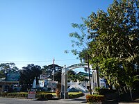 Gate of the Town Hall
 -
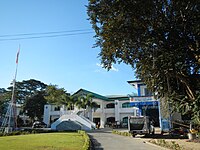 Santo Tomas Town Hall (Municipio)
 -
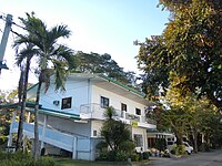 Health Center
 -
 Santo Tomas Gymnasium
 -
 Santo Tomas Elementary School (in front of the Town Hall)


References edit
- ^ Municipality of Santo Tomas | (DILG)
- ^ "2015 Census of Population, Report No. 3 – Population, Land Area, and Population Density" (PDF). Philippine Statistics Authority. Quezon City, Philippines. August 2016. ISSN 0117-1453. Archived (PDF) from the original on May 25, 2021. Retrieved July 16, 2021.
- ^ Error: Unable to display the reference properly. See the documentation for details.
- ^ a b Census of Population (2020). "Region I (Ilocos Region)". Total Population by Province, City, Municipality and Barangay. Philippine Statistics Authority. Retrieved 8 July 2021.
- ^ "PSA Releases the 2018 Municipal and City Level Poverty Estimates". Philippine Statistics Authority. 15 December 2021. Retrieved 22 January 2022.
- ^ "Santo Tomas, Pangasinan: Average Temperatures and Rainfall". World Weather Online. Retrieved 31 October 2015.
- ^ Census of Population (2015). "Region I (Ilocos Region)". Total Population by Province, City, Municipality and Barangay. Philippine Statistics Authority. Retrieved 20 June 2016.
- ^ Census of Population and Housing (2010). "Region I (Ilocos Region)" (PDF). Total Population by Province, City, Municipality and Barangay. National Statistics Office. Retrieved 29 June 2016.
- ^ Censuses of Population (1903–2007). "Region I (Ilocos Region)". Table 1. Population Enumerated in Various Censuses by Province/Highly Urbanized City: 1903 to 2007. National Statistics Office.
{{cite encyclopedia}}: CS1 maint: numeric names: authors list (link) - ^ "Province of Pangasinan". Municipality Population Data. Local Water Utilities Administration Research Division. Retrieved 17 December 2016.
- ^ http://www.pangasinan.org/santotomas/
- ^ "Capital of Pangasinan: All Churches in Pangasinan". 18 February 2008.
- ^ "Poverty incidence (PI):". Philippine Statistics Authority. Retrieved December 28, 2020.
- ^ "Estimation of Local Poverty in the Philippines" (PDF). Philippine Statistics Authority. 29 November 2005.
- ^ "2003 City and Municipal Level Poverty Estimates" (PDF). Philippine Statistics Authority. 23 March 2009.
- ^ "City and Municipal Level Poverty Estimates; 2006 and 2009" (PDF). Philippine Statistics Authority. 3 August 2012.
- ^ "2012 Municipal and City Level Poverty Estimates" (PDF). Philippine Statistics Authority. 31 May 2016.
- ^ "Municipal and City Level Small Area Poverty Estimates; 2009, 2012 and 2015". Philippine Statistics Authority. 10 July 2019.
- ^ "PSA Releases the 2018 Municipal and City Level Poverty Estimates". Philippine Statistics Authority. 15 December 2021. Retrieved 22 January 2022.
- ^ "Santo Tomas | The Official Website of the Province of Pangasinan and its People". www.pangasinan.gov.ph. Archived from the original on 2011-10-28.
- ^ "2019 National and Local Elections" (PDF). Commission on Elections. Retrieved March 7, 2022.
- ^ "Longest barbecue in Guinness records". SunStar. 12 February 2010. Archived from the original on 24 April 2010. Retrieved 27 November 2012.
- ^ "Second Corn Festival". The Philippine STAR.
- ^ http://www.pangasinan.org/santotomas/cornfestival07.htm
- ^ "Philippines Top Stories: Politics, Environment, Education, Trending | Inquirer.net".
- ^ "Kent-the-traveler: Agew na Pangasinan 2012 Street Dancers Showdown". 13 April 2012.
- ^ "Colorful Festivals in Pangasinan | Travel to the Philippines". October 2012.
External links edit
- Santo Tomas Profile at PhilAtlas.com
- Municipal Profile at the National Competitiveness Council of the Philippines
- Santo Tomas at the Pangasinan Government Website
- Local Governance Performance Management System
- Philippine Standard Geographic Code
- Philippine Census Information