


Summary
Sapwuahfik, formerly Ngatik,[1] or the Raven Islands[2] is a 110-square-kilometer (42 sq mi) atoll in Pohnpei state of the Federated States of Micronesia. It is a village and municipality of roughly 430 people on a land area of 1.5 square kilometers (0.58 sq mi).
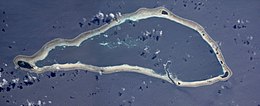 NASA picture of Sapwuahfik Atoll | |
  | |
| Geography | |
|---|---|
| Location | Pacific Ocean |
| Coordinates | 5°47′16″N 157°09′12″E / 5.7878°N 157.1533113°E |
| Total islands | 10 |
| Major islands | Ngatik |
| Length | 22.5 km (13.98 mi) |
| Width | 9.6 km (5.97 mi) |
| Administration | |
Federated States of Micronesia | |
| State | Pohnpei |
| Area covered | 110 km2 (42 sq mi) |
| Demographics | |
| Population | 433 (2010) |
| Languages | |
| Additional information | |
| Time zone |
|
Geography edit
It is located 150 km (93 mi) southwest of the main island of Pohnpei in the Eastern Caroline Islands and consists of 10 individual islands on the reef. The largest and only inhabited island is Ngatik, at the western end.
The atoll is 22.5 km (14.0 mi) long and up to 9.6 km (6.0 mi) wide. The lagoon measures 78.56 km2 (30.33 sq mi) in area, and the total area is 114 km2 (44 sq mi). The aggregate land area of the 10 islands is 1.75 km2 (0.68 sq mi), of which the main island Ngatik is 0.91 km2 (0.35 sq mi), or more than half. While Ngatik is the only inhabited island, the six larger of the remaining islands are used by the population for harvesting coconuts and growing taro, and animal husbandry (pigs and chickens). There are 12 buildings for temporary shelter on those islands.[3]
The islands, clockwise, starting at Ngatik in the west:
| Island | Area km2[3] |
Location |
|---|---|---|
| Ngatik | 0.906 | western end |
| Peina | 0.206 | north |
| Bigen Karakar | 0.025 | northeast |
| Jirup | 0.023 | east |
| Bigen Kelang | 0.047 | east |
| Pikepe (Piken Mategan) | 0.009 | east |
| Dekehnman | 0.009 | eastern end |
| Wat | 0.281 | eastern end |
| Pikenmetkow | 0.006 | southeast |
| Uataluk (Wateiluk) | 0.039 | south |
| Sapwuahfik (Atoll) | 1.551 | fringing reef |
Airfield edit
Sapwuahfik has an airstrip that lies just off the island of Ngatik, the Sapwuahfik Civil Airfield (5°47′01″N 157°10′02″E / 5.783711°N 157.167276°E). Coastal erosion has cut the airstrip off from the island by about 20 meters, making it necessary to ferry arriving and departing passengers between it and Ngatik by boat. There are on-call personnel who go to the airfield whenever a flight is expected.[2]
Population edit
The population of Sapwuahfik was approximately 433 in 2010. The culture is closely related to that of Pohnpei, its closest neighbor; however it retains its own distinctive character.[4]
The local creole, Ngatik Men's Creole, developed as a result of the 1837 Ngatik massacre, during which the island's male population was wiped out by the crew of Australian captain C. H. Hart and Pohnpeian warriors. Some of the Europeans and Pohnpeians settled and repopulated the island, taking the local women as wives. The island formed a new culture and language, a mixture of English and Ngatikese (a Pohnpeic language).[1][4] In addition to the creole, which is only spoken by men, all of the residents speak Ngatikese, a Pohnpeic language closely related to the Pohnpeian language.
History edit
The atoll was first discovered by Westerners on 6 April 1773 by the Spanish naval officer Felipe Tompson when sailing from Manila to San Blas in New Spain on board of the vessel Nuestra Señora de la Consolación also called in short Buen Fin. Tompson charted the island as Los Valientes (the island of the bold in Spanish).[5] At some point between 1793 and 1796, William Raven, captain of Britannia gave a firm sighting to the island.[Note 1]
Solomon Sumner, Seventh-day Adventist Missionary, was buried on the island in 1990.[7]
Education edit
Pohnpei State Department of Education operates public schools:
- Sapwuafik Elementary School[8]
Transportation edit
Sapwuahfik Airfield | |||||||||||
|---|---|---|---|---|---|---|---|---|---|---|---|
| Summary | |||||||||||
| Airport type | Public | ||||||||||
| Owner | Government | ||||||||||
| Operator | Civil Government | ||||||||||
| Serves | Sapwuahfik | ||||||||||
| Runways | |||||||||||
| |||||||||||
Just east of the Sapwuahfik is an Sapwuahfik Airfield with a paved 1,200-foot (370 m) runway.[9]
See also edit
Notes edit
- ^ The source for this information states that Britannia was a British East India Company vessel,[6] which she was not.
References edit
- ^ a b Poyer, Lin (1990). "6. Being Sapwuahfik: Cultural and Ethnic Identity in a Micronesian Society". In Jocelyn Linnekin, Lin Poyer (ed.). Cultural Identity and Ethnicity in the Pacific. University of Hawaii Press. p. 127. ISBN 0824818911. Retrieved 2012-12-15.
- ^ a b "F.S.M. Airports & Civil Airfields--Sapwuahfik Civil Airfield"
- ^ a b Donald W. Buden: The Reptiles of Sapwuahfik Atoll, Federated States of Micronesia Archived 2010-06-27 at the Wayback Machine
- ^ a b Poyer, Lin (1993). The Ngatik massacre: history and identity on a Micronesian atoll. Smithsonian Institution Press. pp. 1–3, 146. ISBN 1560982624. Retrieved 2012-12-15.
- ^ Riesenberg, Saul H. "Six Pacific island discoveries" The American neptune Vol. 34; Salem, Mass. 1974, p.250
- ^ Quanchi, Max (2005). Historical Dictionary of the Discovery and Exploration of the Pacific Islands. The Scarecrow Press. pp. 143–4. ISBN 0810853957.
- ^ https://documents.adventistarchives.org/Periodicals/MissionsQtrly/MQ19930401-V82-02.pdf
- ^ "Pohnpei Schools." Pohnpei State Department of Education. Retrieved on February 23, 2018.
- ^ "Federated States of Micronesia (FSM) Division of Civil Aviation | Sapwuahfik Civil Airfield, Sapwuahfik Atoll, Micronesia".
External links edit
- Sapwuahfik - Oceandots at the Wayback Machine (archived December 23, 2010)
- Deutsches Koloniallexikon (German)
- Statoids.com, retrieved December 8, 2010
- POHNPEI (Islas Carolinas orientales). 3º parte. (Spanish)
5°47′16″N 157°09′20″E / 5.7878°N 157.1555°E