The city served as the capital of the Sur dynasty during Sher Shah Suri's rule over India in the 16th century, and was residence place sub capital of epic monarch Sahastrabahu (Kartivirya Arjuna).
Sasaram and the Kaimur Range contain waterfalls, lakes, rivers and picturesque locations as described by the Ain-I-Akbari. Over 200 waterfalls emerge during the rainy season.
Sasaram city is located in the middle of its other sub-towns like Nokha & Kudra, which have a large number of agriculture based industries, and the city is also emerging as an educational hub. It is situated in the middle of other industrial twin towns like Dehri-on-sone, Dalmianagar, Sonnagar, Amjhor, Nokha and Banjari.
The Sasaram city region is the administrative headquarters of Rohtas district. It was carved out from Shahabad district in 1972. This district headquarters is best known for having the highest literacy rate[4] and highest agricultural & forest cover area of Bihar. Sasaram is also the headquarters of a community development block of the same name, with a total population of 358,283 as of 2011, making it the most populous block in Rohtas district.[5]
It is known for the production of cement, fertilizers, stone chips, and for the quarrying industry.
Sasaram's name derives from Sahastrarama, meaning "one thousand groves". Sasaram was once also named Shah Sarai (meaning "Place of the King"), as it is the birthplace of the Afghan king Sher Shah Suri, who ruled over Delhi, much of northern India, present-day Pakistan, and eastern Afghanistan for five years as the Sur Empire, after defeating the Mughal EmperorHumayun. Many of Sher Shah Suri's governmental practices were adopted by the Mughals and later the British Raj, including taxation, administration, and the building of a paved road from Kabul to Bengal, also called the Grand Trunk Road.
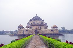
Sher Shah Suri's 122-foot (37 m) red sandstonetomb, built in the Indo-Afghan style, stands in the middle of an artificial lake in Sasaram. It borrows heavily from the Lodhi style, and was once covered in blue and yellow glazed tiles, indicating an Iranian influence. The massive free-standing dome also has an aesthetic aspect of the Buddhiststupa style of the Mauryan period. The tomb of Sher Shah's father, Hasan Khan Suri, is also at Sasaram, and stands in the middle of a green field at Sherganj, which is known as Sukha Rauza. About a kilometre to the north west of Sher Shah's tomb lies the incomplete and dilapidated tomb of his son and successor, Islam Shah Suri.[6] Sasaram also has a Baulia, a pool used by the emperor's consorts for bathing.
The fort of Sher Shah Suri at Rohtasgarh is in Sasaram. This fort has a history dating back to the 7th century CE. It was built by Raja Harishchandra, known for his truthfulness in the name of his son Rohitashwa. It houses the Churasan temple, Ganesh temple, Diwan-i-Khas, Diwan-e-Aam, and various other structures dating back to different centuries. The fort also served as the headquarters of Raja Man Singh during his reign as the governor of Bihar and Bengal under the regime of Akbar. The Rohtas Fort in Bihar should not be confused with another fort of the same name, near Jhelum, Punjab, in present-day Pakistan. The Rohtas Fort in Sasaram was also built by Sher Shah Suri, during the period when Humayun was exiled from Hindustan.
There is a temple of Goddess Tarachandi, two miles to the south, and an inscription of Pratap Dhawal on the rock close to the temple of Chandi Devi.[7] Hindus in large number assemble to worship the goddess. Dhua Kund, a notable waterfall, is located about 15 km (9.3 mi) from the city.
Rohtas, south of Sasaram, is known to have been the residence of one Satyawadi Raja Harischandra, named for his son, Rohitashwa.
Minor Rock Edict of Ashokaedit
Sasaram is also famous for an inscription by Ashoka (one of the thirteen Minor Rock Edicts), situated in a small cave of Kaimur hill, near Chandan Shaheed.
The edict is located near the top of the terminal spur of the Kimur Range near Sasaram.[8] There is the Minor rock edict #1 only.[9] Ashoka famously mentions pre-existing stone pillars in the Edict: "...And where there are stone pillars here in my dominion, there also cause it to be engraved.".
.................. years since I am a lay-worshipper (upasaka).
But (I had) not been very zealous.
A year and somewhat more (has passed) since ............
And men in Jambudvipa, being during that time unmingled with the gods, have (now) been made (by me) mingled with the gods.
[For] this is the fruit [of zeal].
...........cannot be reached by (persons of) high rank alone, (but) even a lowly (person) is able to attain even the great heaven if he is zealous.
Now, for the following purpose (has) this proclamation (been issued), (that) both the lowly and the exalted may be zealous, and (that) even (my) borderers may know (it), and (that this) zeal may be of long duration,
And this matter will (be made by me to) progress, and will (be made to) progress even considerably; it will (be made to) progress to one and a half, to at least one and a half.
And this proclamation (was issued by me) on tour.
Two hundred and fifty-six nights (had then been) spent on tour, — (in figures) 256.
And cause ye this matter to be engraved on rocks.
And where there are stone pillars here (in my dominions), there also cause (it) to be engraved.
— Sasaram Edict (Translated in Inscriptions of Asoka. New Edition by E. Hultzsch)[10]
The Edict is located on top of the terminal spur of the Kimur range.
Sasaram is located at 24°57′N84°02′E / 24.95°N 84.03°E / 24.95; 84.03 and occupies an area of about 15 km2 (5.8 sq mi).[13] It has an average elevation of 110 metres (360 ft). Plateau region of Kaimur Range near Sasaram have average elevation of 210 metres (690 ft).
Climateedit
Sasaram is surrounded by hills from two sides, its climate is seasonable. The climate is characterized by relatively high temperatures and evenly distributed precipitation throughout the year. The Köppen Climate Classification sub-type for this climate is "Cfa" (humid subtropical).[14]
According to the 2011 census, Sasaram had a population of 351,408 but in urban agglomeration. Males constitute 52% of the population and females 48%. Sasaram has an average literacy rate of 80.26%, higher than the national average of 74%; male literacy is 85%, and female literacy is 75%. In Sasaram, 13% of the population is under 6 years of age.[16][verification needed]
SAHAJ Vasudha Kendra, the first "Common Service Centre", or "eKiosk", in Rohtas District was inaugurated in Jamuhar village on 15 August 2008. The centre is currently planning to start a block information Centre, e-district plan, and Sawan Sasaram.
The closure of the industries of the Dalmia Group at Dalmianagar resulted in widespread unemployment. Sasaram's economy is mainly driven by agriculture and related industries like rice polishing. The canal irrigation system is also very prominent in this area. Because of the fertile land around the town, it is a local trading center for food grains, agricultural products, and agricultural equipment, the region is known as Dhan Ka Katora, meaning "a bowl of food grains". The rice grown near Sasaram is sold in the markets of Kolkata and New Delhi. The only significant industry is rock quarrying.
Sasaram Junction station, a major railway station, serves Sasaram. Sasaram's other stations are Shivsagar, Kumahu, Nokha, Karwandiya, Pahleja and Dehri on Sone.
Sasaram is the sixth most literate city in Bihar, with Rohtas being the most literate district in Bihar.[22][23]
There are four government colleges, although many students prefer to go to more developed cities for quality education, such as Bangalore, New Delhi, Pune, Patna, Varanasi and Puducherry, for higher education. A new engineering college has been set up in the region.
This place is also known for preparation of competitive exams at Sasaram Railway junction.[24] According to earlier natives of this city, there was not proper electrification of city around 2007 to 2008, which hampered the studies of students seeking for competitive exams. Indian Railways had a 24-hour power supply at Sasaram junction, leading a small group of students to study there at night under electric lights.
St. Jeelani's Public School, Shahjuma, Sasaram[43]
Pragya Niketan Public School, Falzalganj, Sasaram[44]
Buddha Mission School, Nooranganj, Bauliya Road, Sasaram Rohtas Bihar
Villagesedit
Besides the city of Sasaram itself, there are 171 villages in Sasaram block, of which 144 are inhabited and 27 are uninhabited. As of 2011, the total rural population of Sasaram block is 210,875, in 34,336 households.[5]
^ ab"52nd Report of the Commissioner for Linguistic Minorities in India" (PDF). nclm.nic.in. Ministry of Minority Affairs. Archived from the original (PDF) on 25 May 2017. Retrieved 9 August 2020.
^"Sites along the Uttarapath, Badshahi Sadak, Sadak-e-Azam, Grand Trunk Road". UNESCO World Heritage Centre. Archived from the original on 17 January 2018. Retrieved 16 January 2018.
^"5 BEST Places to Visit in Sasaram - UPDATED 2023 (with Photos & Reviews)". Tripadvisor. Retrieved 28 November 2023.
^"[Solved] Which district of Bihar has the highest literacy rate?". Testbook. Retrieved 28 November 2023.
^ ab"Census of India 2011: Bihar District Census Handbook - Rohtas, Part A (Village and Town Directory)". Census 2011 India. pp. 33, 41–70, 988–1059, 1191–1192. Retrieved 29 June 2020.
^Sanatani, Rohit Priyadarshi. "The Tomb of Salim Shah Suri (Islam Shah): The glory that never was". The Speaking Arch. Archived from the original on 2 April 2015. Retrieved 27 March 2015.
^Shilpa (7 December 2018). "Maa Tara Chandi Temple, Bihar". Bharat Temples. Retrieved 28 November 2023.
^"BLO". Archived from the original on 29 October 2021. Retrieved 25 September 2018.
^India: An Archaeological History: Palaeolithic Beginnings to Early Historic ... by Dilip K. Chakrabarty p.395
^Inscriptions of Asoka. New Edition by E. Hultzsch (in Sanskrit). 1925. p. 171.
^Inscriptions of Asoka. New Edition by E. Hultzsch (in Sanskrit). 1925. pp. 169–171.
^Lahiri, Nayanjot (2015). Ashoka in Ancient India. Harvard University Press. p. 37. ISBN 9780674057777.
^"Maps, Weather, and Airports for Sasaram, India". www.fallingrain.com. Archived from the original on 11 March 2008.
^"Sasaram, India Köppen Climate Classification (Weatherbase)". Weatherbase. Archived from the original on 17 January 2018.
^
"Sasaram, India — Monthly Weather Averages Summary". weatherbase. Archived from the original on 17 January 2018. Retrieved 16 January 2018.
^"Sasaram City Population 2023 | Literacy and Hindu Muslim Population". www.census2011.co.in. Archived from the original on 5 April 2016.
^"Sasaram Lok Sabha Election Result - Parliamentary Constituency". resultuniversity.com. Retrieved 9 January 2024.
^"Sasaram (Bihar) Lok Sabha Election Results 2019, 2014, 2009 -Sasaram Parliamentary Constituency, Winning MP and Party Name". Archived from the original on 31 December 2017. Retrieved 31 December 2017.
^"How to Reach | District Rohtas, Government of Bihar | India". Retrieved 2 February 2024.
^"सासाराम में बनेगा AIRPORT, विमान सेवा के लिए पर्यटन मंत्रालय ने बिहार सरकार से मांगा प्रस्ताव - Live Bihar".
^"सासाराम में एयरपोर्ट बनने की जगी उम्मीद, विमान सेवा के लिए पर्यटन मंत्रालय ने बिहार सरकार से मांगा प्रस्ताव". 21 May 2018.
^Census, India (16 August 2022). "literacy rate in Bihar (2022), including the literacy rate of all districts in Bihar". IndiaCensus.net. Retrieved 16 August 2022.
^ ab"Welcome to GNS University, Sasaram, Bihar". gnsu.org.
^"Welcome to Narayan Medical College & Hospital!". Archived from the original on 26 July 2011.
^"जनमानस की सेवा में निरंतर लगा हुआ है महात्मा फुले मेडिकल कॉलेज एवं हॉस्पिटल". 11 April 2019.
^https://www.spjainsasaram.co.in Archived 17 May 2018 at the Wayback Machine
^"Veer Kunwar Singh University – वीर कुँवर सिंह विश्वविद्यालय, आरा बिहार – 802301". 31 March 2018. Archived from the original on 18 May 2018. Retrieved 17 May 2018.
^"Varsity branch boon for pupils". Archived from the original on 5 June 2018. Retrieved 23 May 2018.
^"sscollegesasaram.org". 19 October 2023. Archived from the original on 25 March 2018.
^"Sher Shah College, Sasaram – [ A constituent unit of Veer Kunwar Singh University, Ara, Bihar ]".


 The Edict is located on top of the terminal spur of the Kimur range.
![The name Jambudīpasi for "India" (Brahmi script) in the Sahasram Minor Rock Edict of Ashoka, circa 250 BCE.[11][12]](//upload.wikimedia.org/wikipedia/commons/thumb/0/08/Jambudiipasi.jpg/120px-Jambudiipasi.jpg) The name Jambudīpasi for "India" (Brahmi script) in the Sahasram Minor Rock Edict of Ashoka, circa 250 BCE.[11][12]
The name Jambudīpasi for "India" (Brahmi script) in the Sahasram Minor Rock Edict of Ashoka, circa 250 BCE.[11][12]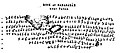 Transcription of the Edict.
 The number "256" towards the end of the Edict.
![The name Jambudīpasi for "India" (Brahmi script) in the Sahasram Minor Rock Edict of Ashoka, circa 250 BCE.[11][12]](http://upload.wikimedia.org/wikipedia/commons/thumb/0/08/Jambudiipasi.jpg/120px-Jambudiipasi.jpg)


 Sasaram travel guide from Wikivoyage