


Summary
Satrampadu is a census town in Eluru district of the Indian state of Andhra Pradesh. It is located in Eluru mandal of Eluru revenue division. The town is a constituent of Eluru urban agglomeration.[1]
Satrampadu | |
|---|---|
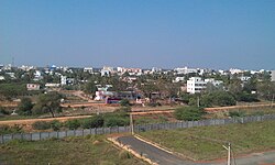 A view of Satramapdu from Mini-Bypass | |
 Satrampadu Location in Andhra Pradesh, India | |
| Coordinates: 16°25′18″N 81°02′33″E / 16.42174°N 81.04238°E | |
| Country | India |
| State | Andhra Pradesh |
| District | Eluru |
| Area | |
| • Total | 1.40 km2 (0.54 sq mi) |
| Population (2011)[1] | |
| • Total | 6,393 |
| • Density | 4,600/km2 (12,000/sq mi) |
| Languages | |
| • Official | Telugu |
| Time zone | UTC+5:30 (IST) |
| PIN | 534 007 |
| Vehicle registration | AP-37 |
Demographics edit
As of 2011[update] census of India, Satrampadu had a population of 6393. The total population constitute, 3,153 males and 3,240 females —a sex ratio of 1023 females per 1000 males. 533 children are in the age group of 0–6 years with child sex ratio of 1090 girls per 1000 boys. The average literacy rate stands at 88.45% with 5654 literates.[1]
Education edit
The primary and secondary school education is imparted by government, aided and private schools, under the School Education Department of the state.[2][3] The medium of instruction followed by different schools are English, Telugu.
References edit
- ^ a b c d "District Census Handbook - West Godavari" (PDF). Census of India. p. 23,278. Retrieved 6 January 2016.
- ^ "School Education Department" (PDF). School Education Department, Government of Andhra Pradesh. Archived from the original (PDF) on 7 November 2016. Retrieved 7 November 2016.
- ^ "The Department of School Education - Official AP State Government Portal | AP State Portal". www.ap.gov.in. Archived from the original on 7 November 2016. Retrieved 7 November 2016.