
KNOWPIA
WELCOME TO KNOWPIA

Saumont-la-Poterie 
Summary
Saumont-la-Poterie (French pronunciation: [somɔ̃ la pɔtʁi]) is a commune in the Seine-Maritime department in the Normandy region in northern France.
Saumont-la-Poterie | |
|---|---|
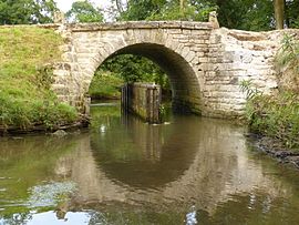 The Pont de Coq in Saumont-la-Poterie | |
Location of Saumont-la-Poterie .mw-parser-output .locmap .od{position:absolute}.mw-parser-output .locmap .id{position:absolute;line-height:0}.mw-parser-output .locmap .l0{font-size:0;position:absolute}.mw-parser-output .locmap .pv{line-height:110%;position:absolute;text-align:center}.mw-parser-output .locmap .pl{line-height:110%;position:absolute;top:-0.75em;text-align:right}.mw-parser-output .locmap .pr{line-height:110%;position:absolute;top:-0.75em;text-align:left}.mw-parser-output .locmap .pv>div{display:inline;padding:1px}.mw-parser-output .locmap .pl>div{display:inline;padding:1px;float:right}.mw-parser-output .locmap .pr>div{display:inline;padding:1px;float:left}html.skin-theme-clientpref-night .mw-parser-output .od,html.skin-theme-clientpref-night .mw-parser-output .od .pv>div,html.skin-theme-clientpref-night .mw-parser-output .od .pl>div,html.skin-theme-clientpref-night .mw-parser-output .od .pr>div{background:#000;color:#fff}html.skin-theme-clientpref-night .mw-parser-output .locmap{filter:grayscale(0.6)}@media(prefers-color-scheme:dark){html.skin-theme-clientpref-os .mw-parser-output .locmap{filter:grayscale(0.6)}html.skin-theme-clientpref-os .mw-parser-output .od,html.skin-theme-clientpref-os .mw-parser-output .od .pv>div,html.skin-theme-clientpref-os .mw-parser-output .od .pl>div,html.skin-theme-clientpref-os .mw-parser-output .od .pr>div{background:#000;color:#fff}}  Saumont-la-Poterie  Saumont-la-Poterie | |
| Coordinates: 49°34′43″N 1°37′06″E / 49.5786°N 1.6183°E | |
| Country | France |
| Region | Normandy |
| Department | Seine-Maritime |
| Arrondissement | Dieppe |
| Canton | Gournay-en-Bray |
| Intercommunality | CC 4 rivières |
| Government | |
| • Mayor (2022–2026) | Nadine Trousse[1] |
| Area 1 | 15.94 km2 (6.15 sq mi) |
| Population (2021)[2] | 414 |
| • Density | 26/km2 (67/sq mi) |
| Time zone | UTC+01:00 (CET) |
| • Summer (DST) | UTC+02:00 (CEST) |
| INSEE/Postal code | 76666 /76440 |
| Elevation | 109–193 m (358–633 ft) (avg. 133 m or 436 ft) |
| 1 French Land Register data, which excludes lakes, ponds, glaciers > 1 km2 (0.386 sq mi or 247 acres) and river estuaries. | |
Geography edit
A farming village situated in the valley of the Epte river in the Pays de Bray, some 24 miles (39 km) northeast of Rouen, at the junction of the D915, D41 and D241 roads.
Population edit
| Year | Pop. | ±% p.a. |
|---|---|---|
| 1968 | 452 | — |
| 1975 | 363 | −3.08% |
| 1982 | 312 | −2.14% |
| 1990 | 365 | +1.98% |
| 1999 | 382 | +0.51% |
| 2007 | 388 | +0.19% |
| 2012 | 400 | +0.61% |
| 2017 | 412 | +0.59% |
| Source: INSEE[3] | ||
Places of interest edit
- An ancient bridge.
- The church of St. Denis, dating from the sixteenth century.
See also edit
References edit
- ^ "Répertoire national des élus: les maires" (in French). data.gouv.fr, Plateforme ouverte des données publiques françaises. 30 November 2023.
- ^ "Populations légales 2021". The National Institute of Statistics and Economic Studies. 28 December 2023.
- ^ Population en historique depuis 1968, INSEE
Wikimedia Commons has media related to Saumont-la-Poterie.