
KNOWPIA
WELCOME TO KNOWPIA

Saveh County 
Summary
Saveh County (Persian: شهرستان ساوه, Romanized as Ŝahrestāne Sāweh, is in Markazi province, Iran. Its capital is the city of Saveh.[3]
Saveh County
Persian: شهرستان ساوه | |
|---|---|
County | |
 Shahrdari Square in the county's capital, Saveh | |
 Location of Saveh County in Markazi province (top, yellow) | |
 Location of Markazi province in Iran | |
| Coordinates: 35°07′N 50°03′E / 35.117°N 50.050°E[1] | |
| Country | |
| Province | Markazi |
| Capital | Saveh |
| Districts | Central, Nowbaran |
| Population (2016)[2] | |
| • Total | 283,538 |
| Time zone | UTC+3:30 (IRST) |
| Saveh County can be found at GEOnet Names Server, at this link, by opening the Advanced Search box, entering "9207307" in the "Unique Feature Id" form, and clicking on "Search Database". | |
At the 2006 census, the county's population was 235,843 in 63,672 households.[4] The following census in 2011 counted 259,030 people in 75,650 households.[5] At the 2016 census, the county's population was 283,538 in 87,444 households.[2]
Administrative divisions edit
The population history and structural changes of Saveh County's administrative divisions over three consecutive censuses are shown in the following table. The latest census shows two districts, seven rural districts, and four cities.[2]
| Administrative Divisions | 2006[4] | 2011[5] | 2016[2] |
|---|---|---|---|
| Central District | 215,413 | 238,041 | 259,354 |
| Nur Ali Beyk RD | 13,417 | 13,222 | 14,530 |
| Qareh Chay RD | 9,956 | 9,665 | 6,056 |
| Shahsavan Kandi RD | 1,537 | 1,007 | 1,781 |
| Taraznahid RD | 11,494 | 13,666 | 12,319 |
| Aveh (city) | 3,906 | ||
| Saveh (city) | 179,009 | 200,481 | 220,762 |
| Nowbaran District | 20,430 | 20,989 | 24,182 |
| Aq Kahriz RD | 4,712 | 3,578 | 4,076 |
| Bayat RD | 5,502 | 5,337 | 6,006 |
| Kuhpayeh RD | 3,891 | 4,912 | 5,391 |
| Gharqabad (city) | 4,394 | 4,992 | 5,375 |
| Nowbaran (city) | 1,931 | 2,170 | 3,334 |
| Total | 235,843 | 259,030 | 283,538 |
| RD: Rural District | |||
Gallery edit
-
-
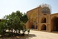
 Imamzadeh Seyed Haroun


Wikimedia Commons has media related to Saveh County.
References edit
- ^ OpenStreetMap contributors (31 August 2023). "Saveh County" (Map). OpenStreetMap. Retrieved 31 August 2023.
- ^ a b c d "Census of the Islamic Republic of Iran, 1395 (2016)". AMAR (in Persian). The Statistical Center of Iran. p. 00. Archived from the original (Excel) on 17 October 2020. Retrieved 19 December 2022.
- ^ Habibi, Hassan (21 June 1369). "Approval of the organization and chain of citizenship of the elements and units of Markazi province's divisions to the citizenship of Arak city". Lamtakam (in Persian). Ministry of Interior, Political Commission of Defense of the Government Board. Archived from the original on 18 January 2024. Retrieved 18 January 2024.
- ^ a b "Census of the Islamic Republic of Iran, 1385 (2006)". AMAR (in Persian). The Statistical Center of Iran. p. 00. Archived from the original (Excel) on 20 September 2011. Retrieved 25 September 2022.
- ^ a b "Census of the Islamic Republic of Iran, 1390 (2011)". Syracuse University (in Persian). The Statistical Center of Iran. p. 00. Archived from the original (Excel) on 19 January 2023. Retrieved 19 December 2022.