


Summary
Schipkau (Lower Sorbian: Šejkow, pronounced [ˈʃɛjkɔw]) is a municipality in the Oberspreewald-Lausitz district, in Lower Lusatia, Brandenburg, Germany.
Schipkau | |
|---|---|
 Coat of arms | |
Location of Schipkau within Oberspreewald-Lausitz district  | |
 Schipkau  Schipkau | |
| Coordinates: 51°31′00″N 13°52′59″E / 51.51667°N 13.88306°E | |
| Country | Germany |
| State | Brandenburg |
| District | Oberspreewald-Lausitz |
| Subdivisions | 6 Ortsteile |
| Government | |
| • Mayor (2018–26) | Klaus Prietzel[1] (CDU) |
| Area | |
| • Total | 72.91 km2 (28.15 sq mi) |
| Elevation | 109 m (358 ft) |
| Population (2022-12-31)[2] | |
| • Total | 6,685 |
| • Density | 92/km2 (240/sq mi) |
| Time zone | UTC+01:00 (CET) |
| • Summer (DST) | UTC+02:00 (CEST) |
| Postal codes | 01993 |
| Dialling codes | 035754 |
| Vehicle registration | OSL |
| Website | www.gemeinde-schipkau.de |
Geography edit
The municipality is located in the north of the historical region of Lusatia, close to the motorway A13, connecting Berlin with Dresden.
Schipkau counts 5 civil parishes (Ortsteile): Annahütte, Drochow, Hörlitz, Klettwitz and Meuro.
History edit
From 1815 to 1947, Schipkau was part of the Prussian Province of Brandenburg. From 1952 to 1990, it was part of the Bezirk Cottbus of East Germany. In 2021, the Energiepark Lausitz[3] project of the municipality of Schipkau was realized on the Klettwitz Hochkippe by GP JOULE[4] with the partners Terravent and Steinbock EE.[5] There, the open spaces between the existing wind turbines are used for the construction and operation of photovoltaic systems.
Demography edit
-
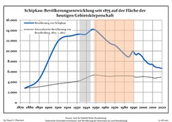 Development of Population since 1875 within the Current Boundaries (Blue Line: Population; Dotted Line: Comparison to Population Development of Brandenburg state; Grey Background: Time of Nazi rule; Red Background: Time of Communist rule)
 -
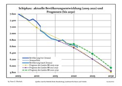 Recent Population Development and Projections (Population Development before Census 2011) (blue line); Recent Population Development according to the Census in Germany in 2011 (blue bordered line); Official projections for 2005-2030 (yellow line); for 2017-2030 (scarlet line); for 2020-2030 (green line)


|
|
|
Sport edit
Close to Klettwitz and in north of Schipkau the "EuroSpeedway Lausitz" is located, a race track originally named "Lausitzring".
References edit
- ^ Landkreis Oberspreewald-Lausitz Wahl der Bürgermeisterin / des Bürgermeisters, accessed 2 July 2021.
- ^ "Bevölkerungsentwicklung und Bevölkerungsstandim Land Brandenburg Dezember 2022" (PDF). Amt für Statistik Berlin-Brandenburg (in German). June 2023.
- ^ Grüner Wasserstoff im Energiepark Lausitz on YouTube, 30 March 2021.
- ^ Der Energiepark Lausitz. GP Joule, retrieved 17 June 2021.
- ^ Lausitzer Netzwerk treibt Wasserstoffzukunft dank Bundesförderung voran. PT-Magazin, 31 January 2021, retrieved 17 June 2021.
- ^ Detailed data sources are to be found in the Wikimedia Commons.Population Projection Brandenburg at Wikimedia Commons
External links edit
![]() Media related to Schipkau at Wikimedia Commons
Media related to Schipkau at Wikimedia Commons