


Summary
Schlanders (German pronunciation: [ˈʃlandɐs]; Italian: Silandro [siˈlandro]) is a comune (municipality) and a village in South Tyrol in northern Italy, located about 50 kilometres (31 mi) west of the city of Bolzano.
Schlanders | |
|---|---|
| Gemeinde Schlanders Comune di Silandro | |
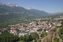 Panorama of Schlanders | |
 Coat of arms | |
Location of Schlanders .mw-parser-output .locmap .od{position:absolute}.mw-parser-output .locmap .id{position:absolute;line-height:0}.mw-parser-output .locmap .l0{font-size:0;position:absolute}.mw-parser-output .locmap .pv{line-height:110%;position:absolute;text-align:center}.mw-parser-output .locmap .pl{line-height:110%;position:absolute;top:-0.75em;text-align:right}.mw-parser-output .locmap .pr{line-height:110%;position:absolute;top:-0.75em;text-align:left}.mw-parser-output .locmap .pv>div{display:inline;padding:1px}.mw-parser-output .locmap .pl>div{display:inline;padding:1px;float:right}.mw-parser-output .locmap .pr>div{display:inline;padding:1px;float:left}html.skin-theme-clientpref-night .mw-parser-output .od,html.skin-theme-clientpref-night .mw-parser-output .od .pv>div,html.skin-theme-clientpref-night .mw-parser-output .od .pl>div,html.skin-theme-clientpref-night .mw-parser-output .od .pr>div{background:#000;color:#fff}html.skin-theme-clientpref-night .mw-parser-output .locmap{filter:grayscale(0.6)}@media(prefers-color-scheme:dark){html.skin-theme-clientpref-os .mw-parser-output .locmap{filter:grayscale(0.6)}html.skin-theme-clientpref-os .mw-parser-output .od,html.skin-theme-clientpref-os .mw-parser-output .od .pv>div,html.skin-theme-clientpref-os .mw-parser-output .od .pl>div,html.skin-theme-clientpref-os .mw-parser-output .od .pr>div{background:#000;color:#fff}}  Schlanders Location of Schlanders in Italy  Schlanders Schlanders (Trentino-Alto Adige/Südtirol) | |
| Coordinates: 46°38′N 10°46′E / 46.633°N 10.767°E | |
| Country | Italy |
| Region | Trentino-Alto Adige/Südtirol |
| Province | South Tyrol (BZ) |
| Frazioni | Göflan (Covelano), Kortsch (Corzes), Nördersberg (Montetramontana), Sonnenberg (Montemezzodì), Vetzan (Vezzano) |
| Government | |
| • Mayor | Dieter Pinggera (SVP) |
| Area | |
| • Total | 115 km2 (44 sq mi) |
| Elevation | 720 m (2,360 ft) |
| Population | |
| • Total | 5,990 |
| • Density | 52/km2 (130/sq mi) |
| Demonym(s) | German: Schlanderser Italian: Silandresi |
| Time zone | UTC+1 (CET) |
| • Summer (DST) | UTC+2 (CEST) |
| Postal code | 39028 |
| Dialing code | 0473 |
| Website | Official website |
Overview edit

Schlanders borders the following municipalities: Latsch, Laas, Mals, Martell, Schnals.
Schlanders is well known for its church tower, 92 metres (302 ft) high, which is also the highest in South Tyrol. Another attraction is the renovated castle, which now serves as a civic hall (including a public library).
The locality was mentioned for the first time officially on 13 June 1077 in a deed of donation, where the Holy Roman Emperor Henry IV. handed over the town to Altwin, the Bishop of Brixen.[citation needed]
Society edit
Linguistic distribution edit
According to the 2011 census, 94.66% of the population speak German, 5.19% Italian and 0.14% Ladin as first language.[4]
Notable people edit
- Marian Tumler (1887–1987) an Austrian theologian and 62nd Grand Master of the Teutonic Order from 1948–1970
- Sport
- René Gusperti (born 1971) former swimmer, competed at the 1992 & 1996 Summer Olympics
- Nicole Gius (born 1980) alpine skier, competed at the 2002 & 2010 Winter Olympics
- Thomas Moriggl (born 1981) cross-country skier, competed at the 2010 Winter Olympics
- Stefan Thanei (born 1981) freestyle skier, competed in the 2018 Winter Olympics
- Barbara Moriggl (born 1982) cross-country skier and soldier
- Thomas Tragust (born 1986) ice-hockey goaltender
- Kevin Strobl (born 1997) badminton player
Twin towns edit
 Trecenta, Italy
References edit
- ^ "Superficie di Comuni Province e Regioni italiane al 9 ottobre 2011". Italian National Institute of Statistics. Retrieved 16 March 2019.
- ^ All demographics and other statistics: Italian statistical institute Istat.
- ^ "Popolazione Residente al 1° Gennaio 2018". Italian National Institute of Statistics. Retrieved 16 March 2019.
- ^ "Volkszählung 2011/Censimento della popolazione 2011". astat info (38). Provincial Statistics Institute of the Autonomous Province of South Tyrol: 6–7. June 2012. Retrieved 2012-06-14.
External links edit
![]() Media related to Schlanders at Wikimedia Commons
Media related to Schlanders at Wikimedia Commons
- Official website (in German and Italian)