
KNOWPIA
WELCOME TO KNOWPIA

Schleithal 
Summary
Schleithal (French pronunciation: [ʃlaital]) is a commune in the Bas-Rhin department in Grand Est in north-eastern France.[3] Located in the northern Lower Rhine just steps from the French-German border. This boundary is defined by the Lauter which gives its name to the small town of Lauterbourg located at the mouth of the river Rhine. Schleithal is a linear settlement.
Schleithal | |
|---|---|
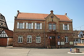 The town hall in Schleithal | |
 Coat of arms | |
Location of Schleithal .mw-parser-output .locmap .od{position:absolute}.mw-parser-output .locmap .id{position:absolute;line-height:0}.mw-parser-output .locmap .l0{font-size:0;position:absolute}.mw-parser-output .locmap .pv{line-height:110%;position:absolute;text-align:center}.mw-parser-output .locmap .pl{line-height:110%;position:absolute;top:-0.75em;text-align:right}.mw-parser-output .locmap .pr{line-height:110%;position:absolute;top:-0.75em;text-align:left}.mw-parser-output .locmap .pv>div{display:inline;padding:1px}.mw-parser-output .locmap .pl>div{display:inline;padding:1px;float:right}.mw-parser-output .locmap .pr>div{display:inline;padding:1px;float:left}html.skin-theme-clientpref-night .mw-parser-output .od,html.skin-theme-clientpref-night .mw-parser-output .od .pv>div,html.skin-theme-clientpref-night .mw-parser-output .od .pl>div,html.skin-theme-clientpref-night .mw-parser-output .od .pr>div{background:#000;color:#fff}html.skin-theme-clientpref-night .mw-parser-output .locmap{filter:grayscale(0.6)}@media(prefers-color-scheme:dark){html.skin-theme-clientpref-os .mw-parser-output .locmap{filter:grayscale(0.6)}html.skin-theme-clientpref-os .mw-parser-output .od,html.skin-theme-clientpref-os .mw-parser-output .od .pv>div,html.skin-theme-clientpref-os .mw-parser-output .od .pl>div,html.skin-theme-clientpref-os .mw-parser-output .od .pr>div{background:#000;color:#fff}}  Schleithal  Schleithal | |
| Coordinates: 48°59′22″N 8°02′39″E / 48.9894°N 8.0442°E | |
| Country | France |
| Region | Grand Est |
| Department | Bas-Rhin |
| Arrondissement | Haguenau-Wissembourg |
| Canton | Wissembourg |
| Government | |
| • Mayor (2022–2026) | Chantal Schmitt[1] |
| Area 1 | 9.12 km2 (3.52 sq mi) |
| Population (2021)[2] | 1,393 |
| • Density | 150/km2 (400/sq mi) |
| Time zone | UTC+01:00 (CET) |
| • Summer (DST) | UTC+02:00 (CEST) |
| INSEE/Postal code | 67451 /67160 |
| Elevation | 135–187 m (443–614 ft) |
| 1 French Land Register data, which excludes lakes, ponds, glaciers > 1 km2 (0.386 sq mi or 247 acres) and river estuaries. | |
History edit
The first writings of Schleithal date from 1145, but some believe that the village dates from 631 (year of establishment of the abbey of Wissembourg). The village became French after the Treaty or otherwise known as Peace of Westphalia in 1648.
See also edit
References edit
- ^ "Répertoire national des élus: les maires" (in French). data.gouv.fr, Plateforme ouverte des données publiques françaises. 6 June 2023.
- ^ "Populations légales 2021". The National Institute of Statistics and Economic Studies. 28 December 2023.
- ^ INSEE commune file
Wikimedia Commons has media related to Schleithal.