


Summary
Seanna Chnoc (English: "old hill"), correctly known as Seana Bheinn[2][3] is an islet in outer Loch Ròg, Lewis, Scotland. It lies north west of Great Bernera and Bearasaigh.
| Scottish Gaelic name | Flodaigh |
|---|---|
| Old Norse name | Flot-ay |
| Meaning of name | raft island |
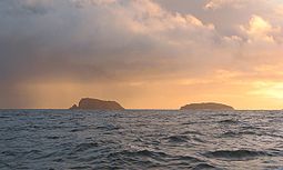 Seana Chnoc (at left) and Bearasaigh from the south west. Stac nam Balg is just visible to the left of Seanna Chnoc | |
| Location | |
 Seanna Chnoc Seanna Chnoc shown within the Outer Hebrides | |
| OS grid reference | NB116413 |
| Coordinates | 58°16′N 6°55′W / 58.27°N 6.91°W |
| Physical geography | |
| Island group | Outer Hebrides |
| Area | <10 ha |
| Highest elevation | 91 metres (299 ft)[1] |
| Administration | |
| Sovereign state | United Kingdom |
| Country | Scotland |
| Council area | Comhairle nan Eilean Siar |
Stac nam Balg lies offshore to the north and there is a cave in the north west of the island.[1]
There is no regular access to the island although boat excursions are available locally.[4]
The correct name for the island is Seanna Bheinn and this is the name that has always been in local use by the local population although it is highly likely an earlier Norse name was used. The name Seanna Chnoc was introduced by the Ordnance Survey through the advice of linguistic academics but is unfortunately incorrect. The island appears to have been called Garvilan in the early 19th century which is an English corruption of Garbh Eilean meaning an inhospitable island[5] and in 1549, Dean Monro wrote: "Besides the coist of Leozus towards the said north-west lyis ane Ile callit Garvellan, gude for store and fishing, perteining to Mccloyd of Leozus".[6]
Notes edit
- ^ a b "Get-a-map". Ordnance Survey. Retrieved 31 July 2010.
- ^ Barrett (2010) p. 136
- ^ "1:10,560 - Epoch 1. Scotland - Isle of Lewis". (1840) Ordnance Survey. British History Online. Retrieved 24 Nov 2012.
- ^ Haswell-Smith (2004) p. 312
- ^ Heather, William (1804) A new and improved chart of the Hebrides or Lewis Islands and adjacent coast of Scotland. National Library of Scotland. Retrieved 30 July 2014.
- ^ Monro (1549) No. 212
References edit
- Barrett, Richard (2010) Walking on Harris and Lewis: 30 Routes in the Outer Hebrides. Cicerone.
- Haswell-Smith, Hamish (2004). The Scottish Islands. Edinburgh: Canongate. ISBN 978-1-84195-454-7.
- Monro, Sir Donald (1549) Description of the Western Isles of Scotland. William Auld. Edinburgh - 1774 edition.
58°17′02″N 6°55′12″W / 58.2838°N 6.9201°W