
KNOWPIA
WELCOME TO KNOWPIA

Selvagem Grande Island 
Summary
Selvagem Grande Island is part of the Savage Islands archipelago, which themselves are part of the Portuguese Autonomous Region of Madeira in the North Atlantic Ocean.
 View of Selvagem Grande | |
 | |
| Geography | |
|---|---|
| Location | Atlantic Ocean |
| Coordinates | 30°08′51″N 15°51′54″W / 30.14750°N 15.86500°W |
| Archipelago | Savage Islands |
| Highest elevation | 163 m (535 ft) |
| Highest point | Pico da Atalaia |
| Administration | |
Portugal | |
| Autonomous Region | Madeira Islands |
| Demographics | |
| Population | no permanent residents (2+ rangers and research personnel) |
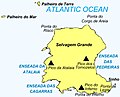
The island (2,000 by 1,700 metres (6,600 ft × 5,600 ft)) belongs to the northeast group of the Savage Islands, which comprises in addition three islets: Sinho Islet, Palheiro de Terra and Palheiro do Mar.[1]
It is generally flat, but has three summits, remnants of former volcanic cones appropriately named Atalaia, Tornozelos and Inferno, Atalaia being the highest of the three, reaching 163 m (535 ft) in altitude.[1]
The island has three residents year-round, two park rangers and a biologist.[1]
The island has a lighthouse, which is automated.[2]
-
 Nautical chart of the archipelago (1884)
 -
 The Selvagem Grande Island
 -
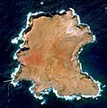 Sentinel-2 image of the island (October 2021)
 -
 Northern Island, aerial view
 -
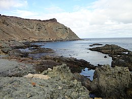
 Side view of the Island
 -
 Warden's base


References edit
- ^ a b c "Marine Biodiversity and Ecosystem Health of Ilhas Selvagens, Portugal" (PDF). National Geographic Society. Retrieved 4 November 2020.
- ^ Lighthouse Depot Online - Selvagem Grande Light Archived 2007-03-10 at the Wayback Machine