


Summary
Seminary Ridge is a dendritic ridge that served as an area of military engagements during the Battle of Gettysburg, the bloodiest battle of the American Civil War, which was fought between July 1 and July 3, 1863 in and around Gettysburg, Pennsylvania. Seminary Ridge also served as a military installation during World War II.
| Seminary Ridge | |
|---|---|
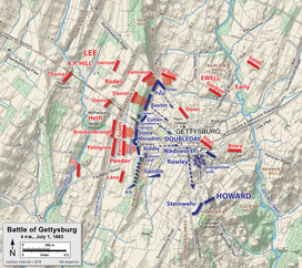 July 1, 1863, at 4:00 p.m.: Union troops (blue) occupied Seminary Ridge. | |
| Highest point | |
| Peak | driveway entrance, SW Confederate Av |
| Elevation | 581.60 ft (177.27 m)[1] |
| Naming | |
| Etymology | Lutheran Theological Seminary |
| Geography | |
| Location | Triple watershed point: Pitzer's Run (west) & both Stevens Creek/Plum Run (east)[citation needed] |
| Country | United States |
| State | Pennsylvania |
| Range coordinates | 39°49′25″N 77°14′43″W / 39.82361°N 77.24528°W |
| Biome | Northern Piedmont ecoregion |
| Geology | |
| Type of rock | Gettysburg-Newark Lowlands and Rossville Diabase dike[2] (50 feet thick) |
Geography edit

Seminary Ridge is a northern portion of the drainage divide between the Marsh Creek Watershed on the west and the Rock Creek Watershed on the east. At the south end of Oak Ridge, the northernmost portion of the divide, the north-south McPherson and Seminary ridges bifurcate southward[3]: 44 at the triple watershed point of Willoughby's and Pitzer runs southward tributaries of Marsh Creek with a Rock Creek eastward tributary. From the triple point, Seminary Ridge extends southward to an area with eastward drainage into Stevens Creek, with the borough of Gettysburg.
Farther south into the Gettysburg National Park, Seminary Ridge continues as far as a branch of Pitzer Run, which divides the ridgeline (39°48′29″N 77°15′20″W / 39.808173°N 77.255516°W), around which the drainage divide curves to the east. The ridgeline continues south of the branch, crossing the Millerstown Road. Between the Millerstown and Emmitsburg road crossings, the west side of the ridgeline is an elevated area (hornfel along the northwest edge of a diabase sheet[4]) about 1 mile wide along the Emmitsburg Road. Along this east side of this elevated area, the ridgeline is Warfield Ridge, the southernmost portion of Seminary Ridge near the south end of the Gettysburg Battlefield. South of the tip of Seminary and Warfield Ridge tip, the Marsh and Rock creeks' drainage divide continues about four miles to near the Mason–Dixon line at their confluence to form Monocacy River.
The portion of Seminary Ridge on the western side of Gettysburg, Pennsylvania includes the railroad cut behind houses north of Buford Avenue[5] and the historic Gettysburg Armory. Extending south are Schultz Woods, Spangler Woods, Berdan Woods, the McMillan Woods Youth Campground,[6] Pitzer Woods, Biesecker's Woods, and the 1895 Longstreet Tower,[7] which provides an observation platform for the "southern end" of Seminary Ridge[8] (Warfield Ridge).[9] Eisenhower National Historic Site, located on the west of the ridge, is visible from the tower.
Seminary Ridge Avenue and the sections of West Confederate Avenue to the northwest and southwest extend along the landform's ridgeline and provide access to numerous battle monuments on the ridge, including the prominent monument to Frederick William Sievers, known as the Virginia monument. Seminary Ridge is crossed by Buford and Springs Avenues and West Middle Street.
South Seminary Ridge edit
South Seminary Ridge is a Gettysburg Battlefield landform south of an east-west branch of Pitzer Run, which separates South Seminary Ridge from a separate landform to the north on the west of Gettysburg with the Lutheran Theological Seminary at Gettysburg. South of the Pitzer Run branch, the ridgeline of South Seminary Ridge extends from Pitzer Woods, across the Millerstown Road, past the Longstreet Tower to the Emmitsburg Road and on to the southernmost state memorial on the battlefield (Alabama), which is just west of the right flank marker for the Confederate Line.
Warfield Ridge is a portion of South Seminary Ridge southward to the Alabama Memorial,[10] and the ridge landform continues southward out of the Gettysburg National Park to where Ridge Road is on the crest.[11]
History edit
In 1761, Samuel Gettys tavern was built near the ridge at the crossroads] east of Stevens Creek, and it preceded both the c. 1812 construction of the Chambersburg Pike across the ridge[12] and the nearby "Gettysburg Theological Seminary"[13] being established on the ridge on August 1, 1826.[14]
In 1832, Old Dorm, now Schmucker Hall, was built,[15] and Pennsylvania College (now Gettysburg College) was started on the east side of the ridge. On the ridge along the Chambersburg Pike, the Thaddeus Stevens building near the seminary (used for Robert E. Lee's 1863 headquarters) was built in 1834.[16] At the time of the battle, the section of the ridge at the extension of West Middle St (the Hagerstown Rd) was known as "Haupt's Hill".[17]
Civil War and postbellum edit
Seminary Ridge was the site of Battle of Gettysburg fighting on July 1, 1863, and the Pitzer Woods engagement on July 2.[18] Robert E. Lee established his headquarters on the ridge just north of the Chambersburg pike, and the ridge also served as the Confederate line of battle for July 2 and 3 attacks against Union Army positions on Cemetery Ridge. On July 3, 500 men in George Pickett's division were killed or wounded on Seminary Ridge, including 88 lost in one regiment of Kemper's Brigade from the Federal artillery counterfire prior to Pickett's Charge.[3]: 134–6 The last hospital patient of the seminary's Old Dorm left on September 16, 1863.[19]
Longstreet Tower (No. 2 of five at Gettysburg) was built on the ridge by the War Department in 1895.[20] West Confederate Avenue was built at the turn of the 20th century[21] for Seminary Ridge tourism, while Sharpshooters Avenue (named Berdan Avenue by 1930)[22] was extended from W Confederate Avenue in 1917 for access to a Pitzer Woods monument.[23] In 1918, various military camp sites (e.g., Camp Colt) were located in the "Field of Pickett's Charge" between the Seminary and Cemetery ridges.[23] The North Carolina Monument was placed on the ridge in 1929.
The Civilian Conservation Corps (CCC) built the 1938 Civil War veteran's camp for the 75th Anniversary of the Battle of Gettysburg[24] and performed Gettysburg Battlefield landscaping through 1941.[25] Construction had begun c. November 1933[26]: g for Gettysburg CCC camp "NP-2", which opened May 26, 1934 on Seminary Ridge and closed in 1941.[27] Renamed from "MP-2", camp NP-2 was in McMillan Woods, while a different CCC camp was in Pitzer Woods[26]: a ("MP-1"/"NP-1") from 1935[28] until closing in April 1937.[29] The Pitzer's Woods camp was for reforestation and a 1933 "cyclone" blew all 45 tents down (200 trees were downed at the Round Tops).[30]: a The "Gettysburg Company 1355, C.C.C." celebrated their 8th anniversary in 1941.[30]: a
World War II and post-war edit
During 1943-4, Camp Sharpe at the former Pitzer Woods CCC camp NP-1 trained soldiers for psychological operations in the European Theater of Operations, and adjacent to Camp Sharpe was a 1944-6 POW camp at CCC camp NP-2 in McMillan Woods. Following the 1950 purchase of the Eisenhower farm, the US Secret Service monitored the tourists using the top of the nearby Longstreet Tower,[31] and the Pitzer Woods amphitheater was constructed in the 1960s[28] The Adams County Historical Society moved to the seminary's Old Dorm on the ridge in 1961, and the National Register of Historic Places added Old Dorm in 1974[19] (the Gettysburg Armory in 1990).[32]
In 1982, the Tennessee State Memorial on West Confederate Avenue was the last confederate state memorial to be dedicated,[33] and the memorial to James Longstreet was erected in Pitzer Woods in 1998 after being planned in 1941.[34] The ridge's Historic Preservation Foundation at 61 Seminary Ridge Av was formed on April 29, 1999.[35]
References edit
- ^ "Y_Value=39.8211&X_Value=-77.2461 ... 581.60". USGS Elevation Web Service Query. United States Geological Survey. Archived from the original on 2011-07-22. Retrieved 2010-02-02.
{{cite web}}: External link in|work= - ^ "Gettysburg National Military Park and Eisenhower National Historic Site: Geologic Resources Inventory Report" (PDF). Denver, Colorado: National Park Service: Natural Resource Program Center. 2009. Archived from the original (PDF) on 2017-05-11. Retrieved 2010-02-02.
- ^ a b Clark, Champ (1987) [1985]. Gettysburg: The Confederate High Tide. The Civil War (Third Printing ed.). Alexandria, Virginia: Time-Life Books. pp. 44, 62, 134, 136.
- ^ "Geology" (PDF). Archived from the original (PDF) on September 28, 2012.
- ^ "Gettysburg Times article". Retrieved 2011-10-15.
- ^ "McMillan Woods Youth Campground - Gettysburg National Military Park (U.S. National Park Service)".
- ^ "Gettysburg Times article 2". Retrieved 2011-10-15.
- ^ Davis, William C. (1995) [1983]. Gettysburg: The Story Behind the Scenery. Fifth Printing. KC Publications. p. 23. ISBN 0-916122-89-1. LCCN 83-80606.
- ^ "Gettysburg National Military Park Virtual Tour Stop#09- Warfield Ridge". Nps.gov. 1933-11-12. Retrieved 2010-06-01.
- ^ "They held the right wing of Lee's valiant host..." Gettysburg National Military Park Virtual Tour Stop#09- Warfield Ridge. NPS.gov. Retrieved 2011-02-27.
On the southern tip of Warfield Ridge stands the Alabama Monument
- ^ Note: South of the Gettysburg National Military Park, the ridgeline naturally extends southward to where the ridgeline ends at Marsh Creek near a former mill at Natural Dam Road near the Mason–Dixon line. However, the ridgeline was cut by the mid-20th century construction of U.S. Route 15 in Pennsylvania.
- ^ "Adams County Civil War Taverns Part 1: Gettysburg LBG John Winkleman". GettysburgDaily.com. December 2009. Retrieved 2020-02-04.
- ^ "Gettysburg Theological Seminary". The Adams Sentinel. April 23, 1928. Retrieved 2010-02-04.
- ^ [Treasurer] (September 6, 1926). "Theological Seminary". The Republican Compiler. Retrieved 2010-02-04.
- ^ Joswick, Dave, ed. (February–March 2008). "Buford's View: July 1, 1863 (advertisement)". The Gettysburg Companion. Times and News Publishing Company. p. 16.
{{cite web}}: Missing or empty|url=(help) - ^ "History of the House and Area". Civil War Headquarters. Retrieved 2010-06-01.
- ^ Transcribed by John Heiser, 1999. "Daniel Skelly and "A Boy's Experiences During the Battle of Gettysburg"". Nps.gov. Archived from the original on 2010-12-22. Retrieved 2010-06-01.
{{cite web}}: CS1 maint: numeric names: authors list (link) - ^ Pfanz, Harry W. (1998-03-01). Gettysburg-The Second Day - Google Books. Univ of North Carolina Press. ISBN 9780807847305. Retrieved 2010-06-01.
- ^ a b "Adams County Historical Society : Headquarters : Brief History of Schmucker Hall". Achs-pa.org. Retrieved 2010-06-01.
- ^ "The Gettysburg Commission Reports" (transcribed versions: 1893-1921, 1927-1933). Gettysburg Discussion Group. Retrieved 2010-02-04.
- original formats: 1895, 1900, 1909, 1913, 1918
- ^ "Gettysburg National Military Park Virtual Tour Stop#08- Longstreet's Headquarters". Nps.gov. Retrieved 2010-06-01.
- ^ "Gettysburg Compiler article". Retrieved 2011-10-15.
- ^ a b "Battlefield Commission: Report from 1917 has Recently been Published". Gettysburg Compiler. January 19, 1918. Retrieved 2010-02-02. (source: p. 995 of annual report)
- ^ [dead link]George F. Nagle. "Research Project-CCC Camps". Afrolumens.org. Archived from the original on September 22, 2007. Retrieved 2010-06-01.
- ^ "WPA and CCC". Nps.gov. Archived from the original on 2006-08-12. Retrieved 2010-06-01.
- ^ a b
"About this Newspaper: Star and Sentinel". Library of Congress: Chronicling America. Retrieved 2010-02-22.
- a. "Change Site of New Camp". September 16, 1933. Retrieved 2010-02-01.
- b. "May Keep 200 Prisoners for Winter Season". September 16, 1944. Retrieved 2010-01-31.
- c. "Fire Company Has Trouble With Truck". Gettysburg, Pennsylvania. October 19, 1946. Retrieved 2010-02-01.
- ^ "Camp Information for NP-2-PA". Pennsylvania CCC Archive. Department of Conservation and Natural Resources. Archived from the original on June 9, 2011. Retrieved 2010-02-01.
- ^ a b "Pitzer Woods". Virtual Tour - Day Two. National Park Service. Retrieved 2010-02-04.
- ^ Speakman, Joseph M (2006). At work in Penn's Woods: the Civilian Conservation Corps in Pennsylvania. Penn State Press. p. 152. ISBN 0271047372. Retrieved 2010-02-04.
- ^ a b
"Gettysburg Times Archives". Gettysburg Times. Archived from the original on 2012-12-05. Retrieved 2010-02-20.
- a. "Twister Causes Much Damage as It Sweeps Through Here Sunday" (Google News Archive). July 3, 1933. Retrieved 2010-03-09.
- b. "Out of the Past: 50 Years Ago". Google News Archive. April 2, 1941. p. 1, col 2. Retrieved 2010-03-09.
- c. "Tells How War Prisoners Are Treated Here" (Google News Archive--transcript available at GDG.). July 14, 1944. Retrieved 2010-03-10.
The Prisoners Are Not Hard to Handle
{{cite web}}: External link in|format= - d. "Out of the Past: 50 Years Ago" (Google News Archive). June 29, 1995. Retrieved 2010-02-01.
- ^ Acrate, Bill (November 13, 1955). "Privacy a Problem for Ike on the Farm: Townspeople Help to Shield Chief Executive". Eugene Register-Guard. Retrieved 2010-02-02.
- ^ "Gettysburg Armory". Great Buildings Collection. Retrieved 2010-02-04.
{{cite web}}: External link in|work= - ^ "The Confederate Battleline". Gettysburg Discussion Group. Retrieved 2010-02-04.
- ^ "Gettysburg Times article 3". Retrieved 2011-10-15.
- ^ "SRHPF Fact Sheet". Seminaryridge.org. 1999-04-29. Retrieved 2010-06-01.