
KNOWPIA
WELCOME TO KNOWPIA

Seninghem 
Summary
Seninghem (French pronunciation: [sənɛ̃ɡɑ̃]) is a commune in the Pas-de-Calais department in the Hauts-de-France region of France.[3]
Seninghem | |
|---|---|
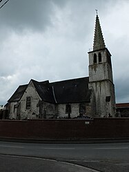 The church of Seninghem | |
 Coat of arms | |
Location of Seninghem .mw-parser-output .locmap .od{position:absolute}.mw-parser-output .locmap .id{position:absolute;line-height:0}.mw-parser-output .locmap .l0{font-size:0;position:absolute}.mw-parser-output .locmap .pv{line-height:110%;position:absolute;text-align:center}.mw-parser-output .locmap .pl{line-height:110%;position:absolute;top:-0.75em;text-align:right}.mw-parser-output .locmap .pr{line-height:110%;position:absolute;top:-0.75em;text-align:left}.mw-parser-output .locmap .pv>div{display:inline;padding:1px}.mw-parser-output .locmap .pl>div{display:inline;padding:1px;float:right}.mw-parser-output .locmap .pr>div{display:inline;padding:1px;float:left}html.skin-theme-clientpref-night .mw-parser-output .od,html.skin-theme-clientpref-night .mw-parser-output .od .pv>div,html.skin-theme-clientpref-night .mw-parser-output .od .pl>div,html.skin-theme-clientpref-night .mw-parser-output .od .pr>div{background:#000;color:#fff}html.skin-theme-clientpref-night .mw-parser-output .locmap{filter:grayscale(0.6)}@media(prefers-color-scheme:dark){html.skin-theme-clientpref-os .mw-parser-output .locmap{filter:grayscale(0.6)}html.skin-theme-clientpref-os .mw-parser-output .od,html.skin-theme-clientpref-os .mw-parser-output .od .pv>div,html.skin-theme-clientpref-os .mw-parser-output .od .pl>div,html.skin-theme-clientpref-os .mw-parser-output .od .pr>div{background:#000;color:#fff}}  Seninghem  Seninghem | |
| Coordinates: 50°42′12″N 2°02′05″E / 50.7033°N 2.0347°E | |
| Country | France |
| Region | Hauts-de-France |
| Department | Pas-de-Calais |
| Arrondissement | Saint-Omer |
| Canton | Lumbres |
| Intercommunality | Pays de Lumbres |
| Government | |
| • Mayor (2020–2026) | Christian Tellier[1] |
| Area 1 | 15.15 km2 (5.85 sq mi) |
| Population (2021)[2] | 693 |
| • Density | 46/km2 (120/sq mi) |
| Time zone | UTC+01:00 (CET) |
| • Summer (DST) | UTC+02:00 (CEST) |
| INSEE/Postal code | 62788 /62380 |
| Elevation | 65–209 m (213–686 ft) (avg. 150 m or 490 ft) |
| 1 French Land Register data, which excludes lakes, ponds, glaciers > 1 km2 (0.386 sq mi or 247 acres) and river estuaries. | |
Geography edit
Seninghem is located approximately 10 miles (16 km) west of Saint-Omer, on the D204 road.
Population edit
| Year | Pop. | ±% p.a. |
|---|---|---|
| 1968 | 455 | — |
| 1975 | 467 | +0.37% |
| 1982 | 445 | −0.69% |
| 1990 | 508 | +1.67% |
| 1999 | 519 | +0.24% |
| 2007 | 584 | +1.49% |
| 2012 | 674 | +2.91% |
| 2017 | 722 | +1.39% |
| Source: INSEE[4] | ||
Places of interest edit
- The seventeenth-century church of St Martin.
- The seventeenth-century chapel of Notre Dame.
- The ‘Arcs de Triomphe’ at the cemetery entrances.
See also edit
References edit
- ^ "Répertoire national des élus: les maires" (in French). data.gouv.fr, Plateforme ouverte des données publiques françaises. 13 September 2022.
- ^ "Populations légales 2021". The National Institute of Statistics and Economic Studies. 28 December 2023.
- ^ INSEE commune file
- ^ Population en historique depuis 1968, INSEE
External links edit
Wikimedia Commons has media related to Seninghem.
- Seninghem on the Quid website (in French)