
KNOWPIA
WELCOME TO KNOWPIA

Serra do Rio do Rastro 
Summary
28°24′26″S 49°32′46″W / 28.40722°S 49.54611°W
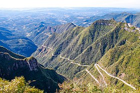
Serra do Rio do Rastro (Portuguese pronunciation: [ˈsɛʁɐ du ˈʁiu du ˈʁastɾu], literally Mountain Range of the River of the Track) is a mountain range located in the southeast of the state of Santa Catarina, Southern Brazil. It is crossed by the road SC-390, with remarkable landscapes and deep cliffs.
This mountain range is situated between the municipalities of Lauro Müller and Bom Jardim da Serra, and its highest point is situated at 1,460 metres (4,790 feet) above sea level. In the highest areas of this place, the Atlantic Ocean, located about 100 km (62 mi) away, can be spotted on clear days. Frosts are common and snowfalls can occur in the highest areas.
See also edit
External links edit
Wikimedia Commons has media related to Serra do Rio do Rastro.
- (in Portuguese) Guide of the municipality of Bom Jardim da Serra