


Summary
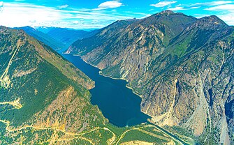
Seton Lake is a lake in the Squamish-Lillooet region of southwestern British Columbia. On the northeast side is Mission Ridge. On the southwest is the Cayoosh Range. By road, the eastern end is about 7 kilometres (4.3 mi) southwest of Lillooet.
| Seton Lake | |
|---|---|
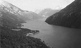 Seton Lake from Mission Mountain, c. 1950 Shalalth and Ohin on points at left. Looking west toward Mount Brew and Lillooet | |
 Seton Lake | |
 | |
| Location | British Columbia |
| Coordinates | 50°41′16″N 122°07′35″W / 50.68778°N 122.12639°W |
| Type | natural lake |
| Primary inflows | glacial feed and Cayoosh Creek from hydro overflow and Carpenter Lake Reservoir. |
| Primary outflows | Seton River |
| Basin countries | Canada |
| Max. length | 21.9 km (13.6 mi) |
| Max. width | 1.1 km (0.68 mi) |
| Surface area | 24.6 km2 (9.5 sq mi) |
| Average depth | 106.2 m (348 ft) |
| Max. depth | 460 m (1,510 ft) |
| Water volume | 2.61 km3 (0.63 cu mi) |
| Surface elevation | 243 m (797 ft) |
Name origin edit
In 1827, Francis Ermatinger of the Hudson's Bay Company (HBC), the first European explorer, referred to the Seton and Anderson lakes as the first and second Peseline Lake (various spellings). In 1846, Alexander Caulfield Anderson paddled along the lakes when seeking a new HBC fur brigade route from Fort Alexandria. In 1858, Governor James Douglas commissioned Anderson to establish a route to the goldfields during the Fraser Canyon Gold Rush.[1] The governor encouraged Anderson to name the lakes after his family. Anderson's cousin Colonel Alexander Seton of the 74th Regiment, who was in command of the troops on board HMS Birkenhead, which sank in 1852, was noted for his exemplary conduct in the moment and was among those who drowned.[2]
The misspelling as "Seaton Lake" on Jorgensen's 1895 map[3] was commonly repeated for decades in both newspaper accounts and government reports.
Dimensions and tributaries edit
The lake is 21.9 kilometres (13.6 mi) long and averages 1.1 kilometres (0.7 mi) wide. The surface area is 24.6 square kilometres (9.5 sq mi). The mean depth is 106.2 metres (348 ft) and maximum depth is 460 metres (1,510 ft). The lake has not completely frozen in recent decades but has in the past.[4] The water is a few degrees colder than Anderson Lake.[5]
The primary inflow (western end) and outflow (eastern end) are the Seton River. Clockwise, the main tributaries are Omin Brook, Carpenter Lake (via Mission Ridge tunnels), Tsee Creek, Ohin Creek, Olin Creek, Ptilla Creek, Puck Creek, Duguid Creek, Madelina Creek, and Audrey Creek, on the northern shore, and Machute Creek on the southern shore.
In 1979, a creek was partially diverted to mix creek water with powerhouse water, so that sockeye salmon would not lose their bearings, but instead proceed upstream to their traditional spawning grounds.[6]
Environment edit
The lake is bounded by snow-capped mountains that descend abruptly to the shores.[7] Environmental conditions largely mirror the Anderson Lake geology, topography, and climate. However, glacial silt from Cayoosh Creek, entering via the power station tunnel, makes the lake water much cloudier than Anderson.[4]
Ferries edit
1858–c.1864 edit
Although a trail existed along the north shore, this section of the Douglas Road was mostly travelled via the lake, initially by canoe.[8] Despite repairs and upgrades to this rudimentary trail over the years, the condition remained as unsuitable for livestock passage.[9]
Built on the lake for Taylor & Co, the 34-metre (110 ft) paddle steamer Champion entered service in June 1860.[10][11] Assumedly, this was the vessel that qualified for the $150 government grant.[12] However, John Colbraith and John Taylor focussed on their hotel at the end of lake, leaving the day-to-day operations of the ferry to Flynn and Kelly.[13]
In 1862, the Short Portage–Lillooet steamer fare was $1.[14] The next year, Taylor & Co, introduced faster paddle steamers, which were the 30-metre (100 ft) Seaton[11] and the 34-metre (110 ft) Prince Alfred.[15][16]
The fate of these vessels is unclear, but the remains of the Seaton were still visible on the lakeshore in 1901.[17]
Intermediate years edit
First Nations provided an informal canoe service.[18]
c.1898–1934 edit
An influx of gold prospectors, which overwhelmed the private boats and barges, highlighted the need for regular lake transportation.[19] In February 1899, the 12-metre (40 ft) steamboat Minnehaha entered service[20] but was destroyed in a violent storm in 1902.[21]
A new steamer was completed in September 1900.[22] The owners built wharves at the foot of the lake and Shalalth.[23] The vessel was likely the 15-metre (50 ft) Britannia,[24] which dominated the lake service after 1902.[21] Its final year on the run to Mission (Shalalth) and Short Portage (Seton Portage) was 1914.[24][25] In May 1912, the 9.1-metre (30 ft) gasoline engine Durban was launched for the same route.[26] That year, the railway contractor made a daily round trip with its gasoline tug and scow.[27] In total, one steamer and two or three gasoline launches carried freight and passengers on the lake that year.[28] The Seton Lake Steamboat Co operated at least until November 1916, apparently with gasoline boats in later years.[29] That summer, Capt. E.W. Cox, who operated a launch on the lake and was about to receive an operating subsidy, drowned while repairing a wharf.[30]
Ernie Marshall and his brother operated a Lillooet–Shalalth ferry until 1934.[31]
Railway edit
By late 1912, seven construction camps had been established along Seton and Anderson Lakes.[32] The next summer, a falling rock killed a worker.[33]
The northward advance of the Pacific Great Eastern Railway (PGE) rail head reached the western end of Seton Lake in late January 1915[34] and the Lillooet vicinity in mid-February.[35]
In 1916, high water extensively damaged the track.[36]
The stations along the north side of the lake have been as follows:
| Train Timetables (Regular stop or Flag stop) | |||||||||||
|---|---|---|---|---|---|---|---|---|---|---|---|
| Mile | 1923 | 1936 | 1943 | 1950 | 1959 | 1969 | 1978 | 1986 | 1996 | 2002 | |
| [37] | [38] | [39] | [40] | [41] | [42] | [43] | [37] | [44] | [45] | [46] | |
| Seton | 138.0 | Regular | Regular | Regular | Flag | Flag | |||||
| Seton Portage | 139.3 | Flag | Flag | Flag | Flag | ||||||
| Bridge River | 141.4 | Regular | |||||||||
| Shalalth a | 142.3 | Flag | Regular | Regular | Regular | Regular | Flag | Flag | Flag | Flag | Flag |
| Retaskit | 149.2 | Flag | Flag | Flag | Flag | Flag | Flag | Flag | |||
| Craig Lodge b | 154.6 | Flag | Flag | ||||||||

^a . Formerly known as the Mission, an unofficial flag stop existed by 1918.[47]
^b . The station may have been an unofficial flag stop by 1916[48] but was definitely one by 1921.[49]
The shuttle along the lake, which commenced as Lillooet–Shalalth in 1934 and became Lillooet–Seton Portage in 1958, would stop most anywhere on request.[50] The service became the Kaoham Shuttle in 2002.[51]
In 1949, the construction of concrete walls eliminated five bridges along the lake.[52]
In January 1950, an avalanche rushing down the mountainside forced a locomotive and tender into the icy lake. The engineer and fireman drowned inside the locomotive,[53] which came to rest 27 metres (90 ft) below the surface.[54]
In December 1964, a diesel locomotive hauling a freight train struck a rockslide on the track, derailed, and plunged into the icy lake. The engineer drowned, but two other crew swam to safety.[55] The locomotive, which rested on a ledge 43 metres (140 ft) underwater, was secured a month later to prevent it from slipping to the bottom of the lake.[56] The PGE implemented a coroner's jury recommendation that a speeder precede all trains along the lake to check for track obstructions.[57] In June 1965, the 120-ton locomotive was raised.[58]
In December 1969, two locomotives and 13 cars of a 77-car freight train derailed. One car rolled into the lake and another caught fire.[59]

In February 1980, a large rock fell upon the track after the speeder passed. On rounding a bend, a southbound 59-car freight train struck the rock, derailing the two lead locomotives and two cars. The locomotives tumbled into the lake, where one crew member swam free but one drowned.[60] In May 1981, BC Rail raised and restored one locomotive. In April 1989, a private citizen raised the second locomotive, but BC Rail expressed no interest in it.[61]
Canadian National Railways have operated the BC Rail line since 2004.[62]
Recreation edit
The one-kilometre return Seton Lake Viewpoint hike offers the lake and mountains as a background and the switchback highway as a foreground. The Upper Bench Loop Trail provides views of Cayoosh Creek, the valley, and Seton Powerhouse. The short trail down to the lake offers lake views. The stoney Seton Lake beach has a boat launch, dock, and several picnic tables. Fishing is better in the creeks and river than the lake.[63]
Maps edit
- "BC map". www.davidrumsey.com. 1925.
- "Shell BC map". www.davidrumsey.com. 1956.
See also edit
Footnotes edit
- ^ "Anderson Lake (lake)". BC Geographical Names.
- ^ McKelvie, Bruce Alistair (1947). Fort Langley: outpost of Empire. p. 112 (94) – via library.ubc.ca.
- ^ "Seton Lake (lake)". BC Geographical Names.
- ^ a b "Influence of glacial turbidity and climate on diatom communities in two Fjord Lakes (British Columbia, Canada)". www.researchgate.net. Jan 2021. pp. 2–4.
- ^ "Minister of Lands annual report, 1913". library.ubc.ca. p. 538 (D462).
- ^ "Prince George Citizen". pgnewspapers.pgpl.ca. 5 Sep 1979. p. 3.
- ^ "Report of the Fisheries Commissioner, 1901". library.ubc.ca. p. 2 (822).
- ^ "Minister of Mines annual report, 1910". library.ubc.ca. p. 152 (K134).
- ^ "Daily Colonist". archive.org. 24 Dec 1875. p. 3.
- ^ "Daily Colonist". archive.org. 12 Jun 1860. p. 1.
- ^ a b Hacking, Norman R. (Jan 1946). "BC Historical Quarterly: Steamboating on the Fraser in the 'Sixties". library.ubc.ca. X (1): 15–16, 43, 46 (11–12, 38, 41).
- ^ "New Westminster Times". library.ubc.ca. 25 Feb 1860. p. 3.
- ^ "Prospector". library.ubc.ca. 4 Apr 1913. p. 1.
- ^ "Daily Colonist". archive.org. 1 Jul 1862. p. 4.
- ^ "Daily Colonist". archive.org. 3 Aug 1863. p. 4.
- ^ Wright, Edgar Wilson (1895). Lewis & Dryden's marine history of the Pacific Northwest. p. 152 (120) – via library.ubc.ca.
- ^ "Prospector". library.ubc.ca. 3 Aug 1901. p. 1.
- ^ "Public Accounts, 1879–80". library.ubc.ca. p. 30 (108).
- ^ Edwards 1976, p. 168.
- ^ "Prospector". library.ubc.ca. 10 Feb 1899. p. 1.
- ^ a b Edwards 1976, p. 171.
- ^ "Prospector". library.ubc.ca. 21 Sep 1900. p. 1.
- ^ "Prospector". library.ubc.ca. 24 Aug 1900. p. 4.
- ^ a b Edwards 1976, p. 204.
- ^ "Prospector". library.ubc.ca. 20 Feb 1914. p. 3.
- ^ "Lillooet Prospector". library.ubc.ca. 10 May 1912. p. 7.
- ^ "Express". library.ubc.ca. 24 Dec 1912. p. 1.
- ^ "Minister of Lands annual report, 1912". library.ubc.ca. p. 347 (D272).
- ^ "Lillooet Prospector". library.ubc.ca. 10 Nov 1916. p. 3.
- ^ "Week". library.ubc.ca. 22 Jul 1916. p. 7.
- ^ "Daily Colonist". archive.org. 8 Jul 1934. p. 25.
- ^ "Fort George Herald". pgnewspapers.pgpl.ca. 7 Dec 1912. p. 1.
- ^ "Daily News". library.ubc.ca. 25 Jul 1913. p. 1.
- ^ "Prospector". library.ubc.ca. 29 Jan 1915. p. 1.
- ^ "Prospector". library.ubc.ca. 19 Feb 1915. p. 1.
- ^ "Week". library.ubc.ca. 5 Aug 1916. p. 7.
- ^ a b Timetable. 17 Dec 1978.
- ^ Timetable. 11 May 1923.
- ^ Official Guide. Jan 1936.
- ^ Timetable. 19 Apr 1943.
- ^ Wolf, Adolf Hungry (1994). Route of the Cariboo. Timetable 25 Sep 1950. Canadian Caboose. p. 39. ISBN 0-920698-37-9.
- ^ Timetable. 15 Feb 1959.
- ^ "Timetable". www.american-rails.com. 1969.
- ^ Timetable. 26 Oct 1986.
- ^ "Timetable". www.rrpicturearchives.net. 1 Apr 1996.
- ^ "Prince George Free Press". www.pgnewspapers.pgpl.ca. 10 Feb 2002. p. 31.
- ^ "Minister of Mines annual report, 1918". library.ubc.ca. p. 247 (K229).
- ^ "Lillooet Prospector". library.ubc.ca. 8 Sep 1916. p. 1.
- ^ Gillespie, Alexander Alistair (1954). Journey through life: biography of Alexander Gillespie. p. 121 (115) – via library.ubc.ca.
- ^ Hind, Patrick O. (Oct 1995). "The Cariboo: PGE's Shalalth Service" (PDF). www.cwrailway.ca. No. 22. pp. 7–13.
- ^ Biln, J. Singh; Roberts, Jay (Fall 2002). "The Cariboo: BC Rail's New Rail Shuttle Vehicles" (PDF). www.cwrailway.ca. No. 41. pp. 18–21.
- ^ "Railway Department annual report, 1949". library.ubc.ca. p. JJ6.
- ^ "Prince George Citizen". pgnewspapers.pgpl.ca. 26 Jan 1950. pp. 1, 4.
- ^ "Prince George Citizen". pgnewspapers.pgpl.ca. 9 Feb 1950. p. 5.
- ^ "Prince George Citizen". pgnewspapers.pgpl.ca. 14 Dec 1964. p. 4.
- ^ "Prince George Citizen". pgnewspapers.pgpl.ca. 6 Jan 1965. p. 9.
- ^ "Prince George Citizen". pgnewspapers.pgpl.ca. 21 Jan 1965. p. 12.
- ^ "Prince George Citizen". pgnewspapers.pgpl.ca. 23 Jun 1965. p. 7.
- ^ "Prince George Citizen". pgnewspapers.pgpl.ca. 17 Dec 1969. p. 3.
- ^ "Prince George Citizen". pgnewspapers.pgpl.ca. 3 Mar 1980. p. 3.
- ^ "Prince George Citizen". pgnewspapers.pgpl.ca. 14 Apr 1989. p. 8.
- ^ "$1-Billion BC Rail Investment Partnership moves forward". Province of British Columbia press releases. Archived from the original on 9 April 2005.
- ^ "Seton Lake: Stunning Blue Water and a Viewpoint Hike". routinelynomadic.com. 13 May 2021.
References edit
- Edwards, Irene (1976). Short Portage to Lillooet. self-published.