


Summary
Shah Faisal Town (Sindhi: شاہ فیصل ٽائونUrdu: شاہ فیصل ٹاؤن), lies in the eastern part of the city that took its name from Shah Faisal Colony.
Shah Faisal Subdivision
شاہ فیصل ٹاؤن شاھ فيصل ٽائون | |
|---|---|
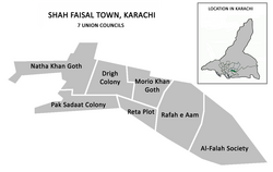 Shah Faisal Subdivision was divided into 7 Union Councils | |
| Coordinates: 24°52′50″N 67°09′45″E / 24.8806°N 67.1625°E | |
| Country | Pakistan |
| Province | Sindh |
| City District | Karachi |
| Established | 2001 |
| Union Councils | |
| Government | |
| • Type | Town Council |
| • Town Nazim (Mayor) | Karim-ud-Din |
| • Municipal Officer | Syed Fuzail Ahmed Bukhari |
| Population | |
| • Total | 447,993 |
| Office location | Town Municipal Administration, Shah Faisal Town, Extension elementary College Block-2, Shah Faisal Colony, near Superior Science College Karachi |
History edit
Shah Faisal Town was formed in 2001 as part of The Local Government Ordinance 2001, and was subdivided into 11 union councils and Shah Faisal Town was re-organized as part of Karachi East District, before being amalgamated into the new Korangi District.
The federal government introduced local government reforms in the year 2000, which eliminated the previous "third tier of government" (administrative divisions) and replaced it with the fourth tier (districts). The effect in Karachi was the dissolution of the former Karachi Division in 2001, and the merging of its five districts to form a new Karachi City-District with 26 autonomous constituent towns including Shah Faisal Town. In 2011, the system was disbanded but remained in place for bureaucratic administration until 2015, when the Karachi Metropolitan Corporation system was reintroduced. In 2015, Shah Faisal Town was re-organized as part of Karachi East district, before being amalgamated into the new Korangi District.
Location edit
The town was bordered by Malir Town to the northeast, Bin Qasim Town to the east, Korangi Town and Landhi Town to the south, and Faisal Cantonment and Malir Cantonment to the west and northwest. The Malir River formed the southern boundary of the town and the Shahrah-e-Faisal highway formed much of the northern boundary with the Jinnah International Airport at the northern end of the town.
Neighbourhoods edit
Shah Faisal Town had twenty-one densely populated neighborhoods:
- Al-Falah Society[2]
- Al-Haider Housing Society
- Azeem Pura
- Hasan Mujtaba Town
- Drigh Colony
- Drigh Road Cantt Bazar
- Golden Town
- Green Town
- Gulshan-e-Muneer
- Iqbalabad
- Kehkashan Society
- Khoso Goth
- Moria Khan Goth
- Natha Khan Goth[2]
- Pak Sadat Colony[2]
- Punjab Town
- Rafah-e-Aam Society[2]
- Raita Plot
- Sachal Goth
- Salman Farsi
- Shah Faisal Colony[2]
- Drigh Colony[2]
Wireless Gate edit
The Wireless Gate serves as a major entrance way to Shah Faisal Town. The name is derived from the abundance of telecommunication installations (PTA) and offices in the area. The area hosted a radio station until the early 1980s. The name wireless gate was given to the railway crossing as the road ends at the gate of the wireless station installation.
See also edit
References edit
- ^ "Shah Faisal Town population per 2017 Census of Pakistan". Citypopulation.de website. Archived from the original on 29 June 2020. Retrieved 12 June 2023.
- ^ a b c d e f "Shah Faisal Town, Karachi, Pakistan". City District Government of Karachi (CDGK) website. Archived from the original on 29 September 2006. Retrieved 12 June 2023.
External links edit
- Shah Faisal Town website - Archived
- Karachi City Government website - Archived