


Summary
Shaw Boulevard (formerly known as Jose Rizal Boulevard and Pasig Boulevard[3] or commonly known as Crossing) is a 4-8 lane highway connecting the cities of Mandaluyong and Pasig in the Philippines. The boulevard is named after William James Shaw, the founder of the Wack Wack Golf and Country Club in Mandaluyong. The road is one of the major thoroughfares of the Ortigas Center in Mandaluyong and Pasig, housing many shopping malls like the Starmall shopping center and the posh Shangri-La Plaza at the EDSA-Shaw intersection and The Marketplace, which is visible from the Kalentong-Shaw intersection and Sevilla Bridge.[4][5]
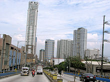 Shaw Boulevard looking east from the crossing flyover | |
| Former name(s) | Jose Rizal Boulevard Pasig Boulevard |
|---|---|
| Namesake | William James Shaw |
| Maintained by | Department of Public Works and Highways - Metro Manila 1st District Engineering Office[1] |
| Length | 5.27 km (3.27 mi)[1][2] |
| Width | Full carriageway 10.0 m (32.8 ft) to 17.4 m (57 ft) Lane width 3.35 m (11.0 ft) to 4.35 m (14.3 ft)[2] |
| Component highways |
|
| Location | Mandaluyong and Pasig |
| West end | Sevilla Bridge at Manila–Mandaluyong boundary |
| Major junctions | |
| East end | |
| Construction | |
| Completion | 1960[2] |
It is served by the Shaw Boulevard station of the MRT-3 along EDSA, often called EDSA-Crossing. The entirety of the road is served by bus and jeepney routes that go to and from Quiapo, Santa Mesa, the José Rizal University, EDSA, Ortigas Center, the Pasig Public Market, and Binangonan, Rizal.
Route description edit


Shaw Boulevard starts as a four-lane road at Sevilla Bridge, which crosses the San Juan River, before coming to an intersection past General Kalentong Street. It is the physical continuation of P. Sanchez Street in Manila. It follows a slightly curved route over Mandaluyong before crossing EDSA. The road expands into four lanes per direction, with two lanes going to the flyover, and two lanes passing below. The flyover carries the road over Shaw Boulevard MRT station and descends near EDSA Shangri-la. The road becomes a dual six-lane carriageway east of EDSA, and soon enters Pasig. Shaw Boulevard eventually is reduced to a four-lane road and extends to C-5 as Pasig Boulevard.

The entire span of the road and its continuations from Sevilla Bridge to Pasig Boulevard have Class II paint-separated one-way bike lanes on both sides of the road as part of the Metropolitan Bike Lane Network.[6] The intersection of Shaw Boulevard, West Capitol Drive, and Camino Verde Road has dedicated bike boxes, which were introduced in September 2021.[7]
Landmarks edit
Schools edit
Shopping Centers edit
- Ortigas Center
- Capitol Commons
- Shangri-La Plaza
- Crossings Department Store (now Rustan's)
- Starmall EDSA Shaw
- EDSA Central Mall
- SM Cherry Shaw Branch
- S&R Membership Shopping Shaw
- 500 Shaw Zentrum
- Super8 Grocery Warehouse Shaw
- Puregold Shaw
- Shaw Center Mall
- Metro Supermarket Shaw Center
- SM Hypermart Mandaluyong
- The Marketplace Shopping Mall
Sports Centers edit
- Gatorade Hoops Center (part of Mandala Park)
- Cherry Turf (part of SM Cherry Shaw)
Offices edit
- Worldwide Corporate Center
- Acquire BPO
- E-Telecare Global Solutions CC7 Shaw Site
- ICT
- NetCrossing 2
- AMA Bank
- Solar Entertainment Corporation
- Nine Media Corporation
- CNN Philippines
- Goldilocks Bakeshop
Transportation edit
Transport terminals edit
- Parklea Jeepney Terminal
- Starmall Shaw Jeepney Terminal
- Starmall Shaw UV Express Terminal
Jeepney Routes edit
- Pasig - Quiapo (T205)[8]
- EDSA/Shaw - Morong (T256)[9]
- EDSA/Shaw - Tanay (T257)[9]
- EDSA/Shaw - Binangonan (T258)[9]
- EDSA/Shaw - Pasig (T295)[8]
- EDSA/Shaw - Taytay (T297)[8]
- EDSA/Shaw - Antipolo (T298)[8]
- EDSA/Shaw - Kalentong/JRU (T347)[9]
UV Express Routes edit
- Pasig - Quiapo (N63)[10]
- Quiapo - SM Megamall (N65)[10]
- Binangonan - Starmall Shaw (N72)[10]
- Taytay - Starmall Shaw (N74)[10]
Railways edit
Intersections edit
| Province | City/Municipality | km | mi | Destinations | Notes |
|---|---|---|---|---|---|
| San Juan River | 7 | 4.3 | Sevilla Bridge | ||
| Mandaluyong | Haig Street | Westbound only | |||
| General Kalentong Street | Traffic light intersection; leads to San Juan to the northeast and Santa Ana, Manila to the southwest. No left turn from eastbound. | ||||
| J. Tiosejo Street | One-way road | ||||
| F. Bernardo Street | One-way road | ||||
| E. Magalona Street / V. Fabella Street | One-way roads | ||||
| A.V. Fabella Street | |||||
| Lawson Street | |||||
| San Clemente Street | |||||
| J.B. Vargas Street | |||||
| E. Jacinto Street | |||||
| Pinagtipunan Street | |||||
| 8 | 5.0 | J. Luna Street | |||
| 29 de Agosto Street | |||||
| L. Gonzales Street / M. Yulo Street | |||||
| L. Cruz Street | |||||
| Araullo Street | Provides access to San Juan | ||||
| R. Vicencio Street / Guerrero Street | |||||
| A. Bonifacio Street | |||||
| Acacia Lane | Traffic light intersection; part of Mabuhay Lane Route 1 | ||||
| Maytunas Creek | Maligaya Bridge | ||||
| Mandaluyong | Gomezville Street / 9 de Pebrero Street | Traffic light intersection; northbound goes to San Juan, southbound goes to Maysilo Circle, Poblacion, Makati via Makati-Mandaluyong Bridge and Estrella–Pantaleon Bridge | |||
| Balagtas Street | One-way road | ||||
| Luna Mencias Street | Provides access to San Juan; part of Mabuhay Lane Routes 1 and 4 | ||||
| Torres Street / Jaime Cardinal Sin Street | |||||
| Calderon Street | |||||
| 9 | 5.6 | Pilar Street | One way road towards Shaw Boulevard from San Juan | ||
| A. Mabini Street | One way road from Shaw Boulevard; provides access to San Juan; part of Mabuhay Lane Route 7 | ||||
| Ideal Street | |||||
| S. Laurel Street | One way road towards Shaw Boulevard | ||||
| Lee Street / Old Wack-Wack Road | Traffic light intersection. Lee Street is one-way from Shaw Boulevard. Old Wack-Wack Road is one-way to Shaw Boulevard until it crosses the road, becoming two-way towards Wack-Wack Village. | ||||
| Princeton Street | Emergency gate for Wack-Wack Village. Eastbound side only. | ||||
| 10 | 6.2 | Samat Street | Eastbound side only. Last intersection on the eastbound direction before the EDSA flyover. | ||
| 10 | 6.2 | Stanford Street | Emergency gate for Wack-Wack Village. Eastbound side only. | ||
| West end of EDSA-Shaw Flyover | |||||
| Yale Street | Emergency gate for Wack-Wack Village. Westbound side only. | ||||
| Harvard Street | Access for Wack-Wack Village. Westbound side only. | ||||
| Traffic light intersection | |||||
| Sto. Cristo Street | Eastbound service road only; one-way road | ||||
| Mayflower Street | Eastbound service road only; provides access to Greenfield District; last intersection on the westbound direction before the EDSA flyover | ||||
| East end of EDSA-Shaw Flyover | |||||
| St. Francis Street | Westbound direction only; provides access to Ortigas Center | ||||
| Buayang Bato Creek | |||||
| Mandaluyong–Pasig boundary | 11 | 6.8 | Sheridan Street / San Miguel Avenue | Traffic light intersection; northbound goes to Ortigas Center, southbound goes to Greenfield District | |
| Pasig | Escriva Drive | Westbound only; provides access to Ortigas Center | |||
| Pioneer Street / General Roxas Street | Traffic light intersection | ||||
| 11.5 | 7.1 | Meralco Avenue | Traffic light intersection; provides access to Capitol Commons and Ortigas Avenue. Closed until 2028 for the construction of Metro Manila Subway.[11][12] | ||
| Camino Verde Road / West Capitol Drive | Traffic light intersection. Capitol Commons service road. Provides access to the Kapitolyo district in Pasig. | ||||
| Oranbo Drive | Westbound only. | ||||
| 12 | 7.5 | San Roque Street / Canley Road (Danny Floro Street) | Traffic light intersection | ||
| 12 | 7.5 | Eastern terminus; Hillcrest Drive is not accessible to vehicles coming from Shaw Boulevard | |||
1.000 mi = 1.609 km; 1.000 km = 0.621 mi
| |||||
References edit
- ^ a b "Metro Manila 1st". Department of Public Works and Highways. Retrieved August 2, 2020.
- ^ a b c "Road and Bridge Inventory". www.dpwh.gov.ph. Retrieved August 2, 2020.
- ^ Manila, Philippines map (Map). American Red Cross Service Bureau. August 1945. Retrieved April 25, 2021.
- ^ 1
- ^ 2
- ^ "List of all bike lanes based on DPWH classifications". Freedom of Information Philippines. August 25, 2022. Retrieved August 11, 2023.
- ^ Laurel, Drei (September 15, 2021). "Can this new intersection in Pasig serve as a model for other cities?". Top Gear Philippines. Retrieved August 11, 2023.
- ^ a b c d "AADDITIONAL ROUTES ALLOWED FOR THE OPERATION OF UV EXPRESS VEHICLES DURING THE PERIOD OF GCQ IN METRO MANILA" (PDF). Land Transportation Franchising and Regulatory Board. April 10, 2021. Retrieved December 12, 2021.
- ^ a b c d "ADDITIONAL ROUTES ALLOWED FOR THE OPERATION OF TRADITIONAL PUJ VEHICLES DURING THE PERIOD OF GCQ IN METRO MANILA AND ENTERING METRO MANILA" (PDF). Land Transportation Franchising and Regulatory Board. October 7, 2020. Retrieved December 12, 2021.
- ^ a b c d "AADDITIONAL ROUTES ALLOWED FOR THE OPERATION OF UV EXPRESS VEHICLES DURING THE PERIOD OF GCQ IN METRO MANILA AND ENTERING METRO MANILA" (PDF). Land Transportation Franchising and Regulatory Board. May 2, 2021. Retrieved December 12, 2021.
- ^ Sarao, Zacarian (September 11, 2022). "Portion of Meralco Ave. in Pasig City to be closed until 2028 for subway project". INQUIRER.net. Retrieved September 14, 2022.
- ^ Galvez, Daphne (October 3, 2022). "Bongbong Marcos leads groundbreaking for 2 Metro Manila subway stations". INQUIRER.net. Retrieved October 5, 2022.
14°35′7″N 121°2′54″E / 14.58528°N 121.04833°E