


Summary
The Shenango River is a principal tributary of the Beaver River, approximately 100 mi (160 km) long,[6] in western Pennsylvania in the United States. It also briefly flows through small portions of northeastern Ohio.[7] Via the Beaver and Ohio Rivers, it is part of the watershed of the Mississippi River.
| Shenango River Tributary to Beaver River | |
|---|---|
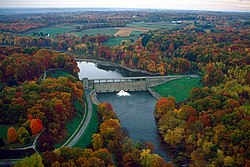 The Shenango River, flowing from the dam of Shenango River Lake in South Pymatuning Township, Mercer County, Pennsylvania | |
 | |
| Location | |
| Country | United States |
| State | Pennsylvania Ohio |
| Counties | Ashtabula (OH) Crawford (PA) Lawrence (PA) Mercer (PA) |
| Physical characteristics | |
| Source | Pymatuning Swamp (divide between Shenango River and French Creek) |
| • location | Sadsbury Township, Pennsylvania[1] |
| • coordinates | 41°33′21″N 080°25′41″W / 41.55583°N 80.42806°W[2] |
| • elevation | 1,010 ft (310 m)[3] |
| Mouth | Beaver River |
• location | New Castle, Pennsylvania[3] |
• coordinates | 40°57′29″N 080°22′43″W / 40.95806°N 80.37861°W[2] |
• elevation | 760 ft (230 m)[3] |
| Length | 82.66 mi (133.03 km)[4] |
| Basin size | 1,065.33 square miles (2,759.2 km2) |
| Discharge | |
| • location | Beaver River |
| • average | 1,381.73 cu ft/s (39.126 m3/s) at mouth with Beaver River[5] |
| Basin features | |
| Progression | South |
| River system | Beaver River |
| Tributaries | |
| • left | Little Shenango River Mathay Run Lawango Run Lackawannock Creek Daley Run Magargee Run Pine Hollow Run Thornton Run Pine Run Buchanon Run Neshannock Creek Big Run |
| • right | Linesville Creek Ashtabula River Gravel Run Black Creek McMichaels Creek Sugar Run Big Run Brush Run Chestnut Run Pymatuning Creek McCullough Run Big Run Yankee Run Turkey Run Deer Creek |
| Waterbodies | Pymatuning Lake Shenango Lake |
The Shenango, whose name comes from the Iroquoian "Shanango," meaning "the beautiful one," rises in west-central Crawford County[6] and initially flows northwestwardly into the Pymatuning Reservoir, which was formed in 1934 by the construction of a dam on the river.[8] The lake turns to the south, widening into Ashtabula County, Ohio, and passing through Pymatuning State Park.[7] Below the dam and after returning fully to Pennsylvania, the Shenango flows south-southeastwardly into Mercer County, flowing through Jamestown and Greenville before turning westwardly into Shenango River Lake,[7] formed in 1965 by a United States Army Corps of Engineers dam.[9] Below that dam, the Shenango flows southwestwardly through the communities of Sharpsville and Sharon (near which it briefly enters Trumbull County, Ohio); then south-southeastwardly past Farrell, Wheatland and West Middlesex into Lawrence County, where it passes New Castle and Oakland.[7] It joins the Mahoning River to form the Beaver River, 3 mi (4.8 km) southwest of New Castle.[6]
Tributaries of the Shenango include the short Little Shenango River,[10] which flows for its entire length in Mercer County and joins the Shenango from the east at Greenville; Pymatuning Creek, which flows into Shenango River Lake; and Neshannock Creek, which joins the river at New Castle.[7]
See also edit
References edit
- U.S. Geological Survey Geographic Names Information System: Shenango River
- ^ "New Castle Topo Map, Lawrence County PA (New Castle North Area)". TopoZone. Locality, LLC.
- ^ a b "GNIS Detail - Shenango River". geonames.usgs.gov. US Geological Survey. Retrieved 28 July 2019.
- ^ a b c "New Castle Topo Map, Lawrence County PA (New Castle North Area)". TopoZone. Locality, LLC. Retrieved 28 July 2019.
- ^ "ArcGIS Web Application". epa.maps.arcgis.com. US EPA. Retrieved 28 July 2019.
- ^ "Shenango River Watershed Report". Waters Geoviewer. US EPA. Retrieved 28 July 2019.
- ^ a b c Columbia Gazetteer of North America entry for Shenango River Archived 2007-03-12 at the Wayback Machine
- ^ a b c d e DeLorme (2003). Pennsylvania Atlas & Gazetteer. Yarmouth, Maine: DeLorme. ISBN 0-89933-280-3
- ^ Columbia Gazetteer of North America entry for Pymatuning Reservoir Archived 2007-03-12 at the Wayback Machine
- ^ United States Army Corps of Engineers website for Shenango River Lake Archived 2007-10-27 at the Wayback Machine
- ^ U.S. Geological Survey Geographic Names Information System: Little Shenango River
External links edit
- U.S. Geological Survey: PA stream gaging stations
- Shenango River Watchers