


Summary
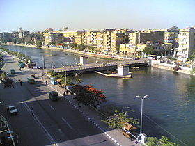
Shibin El Kom (Arabic: شبين الكوم pronounced [ʃɪˈbiːn elˈkoːm], colloquially shortened to Shibin) is a city in Egypt's Nile Delta, and the capital of the Monufia Governorate.[2] 30°33′31″N 31°0′36″E / 30.55861°N 31.01000°E
Shibin El Kom
شبين الكوم | |
|---|---|
     | |
 Location in Monufia Governorate | |
 Shibin El Kom Location in Egypt | |
| Coordinates: 30°33′31″N 31°00′36″E / 30.55861°N 31.01000°E | |
| Country | |
| Governorate | Monufia |
| Area | |
| • City | 28.51 km2 (11.01 sq mi) |
| Elevation | 23 m (75 ft) |
| Population (2021)[1] | |
| • City | 267,945 |
| • Density | 9,400/km2 (24,000/sq mi) |
| • Metro | 630,000 |
| Time zone | UTC+2 (EET) |
| Area code | (+20) 48 |
Etymology edit
The city was previously known as Shaybin as-Ssarya (Arabic: شيبين السَّرِى) the first part of which Ramzi connects to Arabic: أشيب ʾašyab "grey-coloured, old".[3][4] It appears to be a translation of Latin: veteranorum, lit. 'of veterans/old' akin to Shaybin al-Qasr (Arabic: شيبين القصر, lit. 'castle of the old', Latin: Scenae Veteranorum, lit. 'tents of veterans/old'), modern Shibin el-Qanatir, and possibly points out that Shibin el Kom used to be one of the Roman military camps in Lower Egypt.
Facilities edit
While the city is not a new one, its infrastructure is being modernized. The most important central and local government offices are located in the city, as well as the main branches of Menoufia University. The city has several public and private schools, hospitals, a large stadium, a regional office of Telecom Egypt, organized trade unions, athletic teams, political parties and social organizations and a chamber of commerce.
Climate edit
Shibin's climate is classified by Köppen-Geiger climate classification system as hot desert (BWh), as the rest of Egypt.
The highest record temperature was 48 °C (118 °F) recorded on June 7, 1961, while the lowest record temperature was −3 °C (27 °F) recorded on January 23, 1996.[5]
| Climate data for Shibin Al Kawm, Egypt | |||||||||||||
|---|---|---|---|---|---|---|---|---|---|---|---|---|---|
| Month | Jan | Feb | Mar | Apr | May | Jun | Jul | Aug | Sep | Oct | Nov | Dec | Year |
| Record high °C (°F) | 31 (88) |
37 (99) |
40 (104) |
46 (115) |
44 (111) |
48 (118) |
44 (111) |
44 (111) |
44 (111) |
41 (106) |
39 (102) |
33 (91) |
48 (118) |
| Mean daily maximum °C (°F) | 18.9 (66.0) |
21 (70) |
23.7 (74.7) |
27.3 (81.1) |
32.1 (89.8) |
34.5 (94.1) |
34.5 (94.1) |
34.5 (94.1) |
32.4 (90.3) |
29.9 (85.8) |
25 (77) |
20.5 (68.9) |
27.9 (82.2) |
| Daily mean °C (°F) | 12.2 (54.0) |
13.9 (57.0) |
16.2 (61.2) |
19.1 (66.4) |
23.7 (74.7) |
26.4 (79.5) |
27.1 (80.8) |
27.1 (80.8) |
25.1 (77.2) |
22.6 (72.7) |
18.7 (65.7) |
14.1 (57.4) |
20.5 (69.0) |
| Mean daily minimum °C (°F) | 5.6 (42.1) |
6.9 (44.4) |
8.8 (47.8) |
11 (52) |
15.3 (59.5) |
18.3 (64.9) |
19.7 (67.5) |
19.7 (67.5) |
17.8 (64.0) |
15.3 (59.5) |
12.5 (54.5) |
7.8 (46.0) |
13.2 (55.8) |
| Record low °C (°F) | −3 (27) |
−2 (28) |
0 (32) |
3 (37) |
9 (48) |
10 (50) |
17 (63) |
14 (57) |
16 (61) |
10 (50) |
2 (36) |
−2 (28) |
−3 (27) |
| Average precipitation mm (inches) | 7 (0.3) |
6 (0.2) |
3 (0.1) |
2 (0.1) |
0 (0) |
0 (0) |
0 (0) |
0 (0) |
0 (0) |
2 (0.1) |
4 (0.2) |
8 (0.3) |
32 (1.3) |
| Source 1: Climate-Data.org[6] | |||||||||||||
| Source 2: Voodoo Skies[5] for record temperatures | |||||||||||||
Museums edit
See also edit
References edit
- ^ a b "Shibīn al-Kawm (Kism (fully urban), Egypt) - Population Statistics, Charts, Map and Location". www.citypopulation.de. Retrieved 17 June 2023.
- ^ "Sheben El Koum". Monofeya Egypt Governorate. Archived from the original on 2018-02-23. Retrieved 2018-11-20.
- ^ ابن مماتي ص156
- ^ Peust, Carsten. Die Toponyme vorarabischen Ursprungs im modernen Ägypten. p. 85.
- ^ a b "Shibin el-Kom, Egypt". Voodoo Skies. Archived from the original on 2015-06-10. Retrieved 4 July 2013.
- ^ "Climate: Shibin Al-Kom - Climate graph, Temperature graph, Climate table". Climate-Data.org. Archived from the original on 2014-08-26. Retrieved 13 August 2013.