


Summary
The Shire of Cambooya was a local government area in the Darling Downs region of Queensland, Australia, immediately south of the regional city of Toowoomba. The shire, administered from the town of Greenmount, covered an area of 638.5 square kilometres (246.5 sq mi), and existed as a local government entity from 1914 until 2008, when it amalgamated with several other councils in the Toowoomba area to form the Toowoomba Region.
| Shire of Cambooya Queensland | |||||||||||||||
|---|---|---|---|---|---|---|---|---|---|---|---|---|---|---|---|
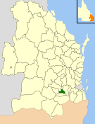 Location within Queensland | |||||||||||||||
| Population | 5,652 (2006 census)[1] | ||||||||||||||
| • Density | 8.8520/km2 (22.927/sq mi) | ||||||||||||||
| Established | 1914 | ||||||||||||||
| Area | 638.5 km2 (246.5 sq mi) | ||||||||||||||
| Council seat | Greenmount | ||||||||||||||
| Region | Darling Downs | ||||||||||||||
| Website | Shire of Cambooya | ||||||||||||||
| |||||||||||||||
Its main pursuits included dairying and beef cattle, pig production, horse spelling and breeding, grain growing and vegetable production. The northern section, containing rural-residential suburbs such as Vale View and Hodgson Vale, are commuter districts within 12 kilometres (7 mi) of Toowoomba's urban core.
History edit
The Shire of Cambooya was created by severance from the Shire of Clifton. It absorbed part of the Tarampa Shire in 1915, and part of Drayton in 1949.[2][3]
Cambooya had four divisions electing two councillors each, with a separately elected mayor.
On 15 March 2008, under the Local Government (Reform Implementation) Act 2007 passed by the Parliament of Queensland on 10 August 2007, the Shire of Cambooya merged with the City of Toowoomba and the Shires of Clifton, Crows Nest, Jondaryan, Millmerran, Pittsworth and Shire of Rosalie to form the Toowoomba Region.
Towns and localities edit
The Shire of Cambooya includes the following settlements:
- Cambooya
- East Greenmount
- Finnie1
- Greenmount
- Hodgson Vale1
- Mount Rascal1
- Nobby2
- Top Camp1
- Vale View1
- Westbrook
- Wyreema3
1 - split with the former City of Toowoomba
2 - split with the former Shire of Clifton
3 - split with the former Shire of Jondaryan
Population edit
| Year | Population |
|---|---|
| 1933 | 2,047 |
| 1947 | 1,780 # |
| 1954 | 1,848 |
| 1961 | 1,732 |
| 1966 | 1,617 |
| 1971 | 1,558 |
| 1976 | 1,676 |
| 1981 | 1,894 |
| 1986 | 2,477 |
| 1991 | 2,860 |
| 1996 | 4,079 |
| 2001 | 4,856 |
| 2006 | 5,652 |
# The estimated 1947 population of the post-1949 area was 1,959.[4]
Chairmen and mayors edit
The leaders of the Cambooya Shire Council were:[5]
Chairmen edit
- 1914—1916: Arthur Hoey Davis, better known as the author Steele Rudd
- 1916: James Purcell
- 1916—1918: Edward Fitzgerald
- 1918—1919: Timothy O'Rourke
- 1919—1920: William Purcell
- 1920—1921: Malcolm Brodie
- 1921—1923: James Lemon
- 1924—1939: Edward Fitzgerald
- 1939—1943: Samuel John Gilmour
- 1943—1949: William Henry Lipp
- 1949—1966: Leslie Ashby Free
- 1966—1973: George Gordon Savage
- 1973—1976: George Hannaford
- 1976—1982: George Gordon Savage
- 1982—1985: William Archibald Woods
- 1985—1993: Thomas Stratford Newman
Mayors edit
- 1993-2000: Robert Leslie Free
- 2000-2004: John Gordon Savage
- 2004-2008: Carol Estelle Taylor
References edit
- ^ Australian Bureau of Statistics (25 October 2007). "Cambooya (S) (Local Government Area)". 2006 Census QuickStats. Retrieved 18 March 2008.
- ^ Toowoomba Regional Council (2004). "A Brief History of Cambooya Shire". Archived from the original on 19 July 2008. Retrieved 2 April 2008.
- ^ "Untitled". Queensland Government Gazette. 17 March 1949. p. 172:981–985.
- ^ Queensland Year Book, No.11 (1950), p.47.
- ^ "Cambooya Shire Council Past Chairmen and Mayors". Toowoomba Regional Council. Archived from the original on 3 February 2014. Retrieved 4 February 2014.
External links edit
- University of Queensland: Queensland Places: Cambooya Shire
- Official website at the Wayback Machine (archived February 23, 2008)
27°47′17″S 151°54′16″E / 27.78806°S 151.90444°E