


Summary
The Shire of Exmouth is a local government area in the Gascoyne region of Western Australia, about 1,000 kilometres (600 mi) north of the state capital, Perth. The Shire covers an area of 6,503 square kilometres (2,511 sq mi), and its seat of government is the town of Exmouth.
| Shire of Exmouth Western Australia | |||||||||||||||
|---|---|---|---|---|---|---|---|---|---|---|---|---|---|---|---|
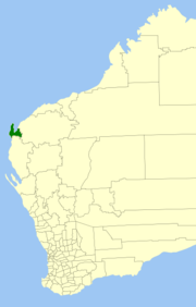 Location in Western Australia | |||||||||||||||
 | |||||||||||||||
| Population | 3,085 (LGA 2021)[1] | ||||||||||||||
| Established | 1964 | ||||||||||||||
| Area | 6,502.8 km2 (2,510.7 sq mi) | ||||||||||||||
| Shire President | Matt Niikkula[2] | ||||||||||||||
| Council seat | Exmouth | ||||||||||||||
| Region | Gascoyne | ||||||||||||||
| State electorate(s) | North West | ||||||||||||||
| Federal division(s) | Durack | ||||||||||||||
| Website | Shire of Exmouth | ||||||||||||||
| |||||||||||||||
History edit
The Shire of Exmouth was formed on 1 January 1964 by splitting from the Shire of Carnarvon. The original council had five members.[3]
Wards edit
The shire was not divided into wards and the seven councillors sit at large.
Towns and localities edit
The towns and localities of the Shire of Exmouth with population and size figures based on the most recent Australian census:[4][5]
| Suburb | Population | Area | Map | |||
|---|---|---|---|---|---|---|
| Cape Range National Park | 18 (SAL 2021)[6] | 503.3 km2 (194.3 sq mi) | 
| |||
| Exmouth | 2,806 (SAL 2021)[7][8] | 50.7 km2 (19.6 sq mi) | Exmouth Gulf | 49 (SAL 2021)[9] | 4,934.3 km2 (1,905.1 sq mi) | 
|
| Learmonth | 25 (SAL 2021)[10] | 334.4 km2 (129.1 sq mi) | Ningaloo | 7 (SAL 2021)[11] | 531.8 km2 (205.3 sq mi) | 
|
| North West Cape | 177 (SAL 2021)[12] | 298.6 km2 (115.3 sq mi) |
Heritage-listed places
edit
As of 2024[update], 38 places are heritage-listed in the Shire of Exmouth,[13] of which six are on the State Register of Heritage Places, among them the Vlamingh Head Lighthouse.[14] References edit
External links edit
21°55′59″S 114°07′41″E / 21.933°S 114.128°E |