


Summary
The Shire of Merredin is a local government area in the Wheatbelt region of Western Australia, about 250 kilometres (155 mi) east of Perth, the state capital. Its seat of government is the town of Merredin, where 2,804 of the Shire's 3,595 residents live. The Shire covers an area of 3,300 square kilometres (1,274 sq mi).
| Shire of Merredin Western Australia | |||||||||||||||
|---|---|---|---|---|---|---|---|---|---|---|---|---|---|---|---|
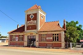 The state heritage listed Merredin District Hall, 2014 | |||||||||||||||
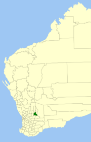 Location in Western Australia | |||||||||||||||
 | |||||||||||||||
| Population | 3,119 (LGA 2021)[1] | ||||||||||||||
| Area | 3,299.7 km2 (1,274.0 sq mi) | ||||||||||||||
| Shire President | Mark McKenzie | ||||||||||||||
| Council seat | Merredin | ||||||||||||||
| Region | Wheatbelt | ||||||||||||||
| State electorate(s) | Central Wheatbelt | ||||||||||||||
| Federal division(s) | Durack | ||||||||||||||
| Website | Shire of Merredin | ||||||||||||||
| |||||||||||||||
History edit
On 30 June 1921, the Merredin Road District was created. On 1 July 1961, it became a shire under the Local Government Act 1960.[2]
Wards edit
On 3 May 2003, all wards were abolished and all 11 councillors sit at large.
Prior to this, the ward structure was as follows:
- Central Ward (7 councillors)
- North West Ward
- North East Ward
- South West Ward
- Totadgin Ward
Towns and localities edit
The towns and localities of the Shire of Merredin with population and size figures based on the most recent Australian census:[3][4]
| Locality | Population | Area | Map | ||||||||||||||||||||||||||||||||||||||||||||||||||||||||||||||||||||||||||
|---|---|---|---|---|---|---|---|---|---|---|---|---|---|---|---|---|---|---|---|---|---|---|---|---|---|---|---|---|---|---|---|---|---|---|---|---|---|---|---|---|---|---|---|---|---|---|---|---|---|---|---|---|---|---|---|---|---|---|---|---|---|---|---|---|---|---|---|---|---|---|---|---|---|---|---|---|---|
| Burracoppin | 114 (SAL 2021)[5] | 312.7 km2 (120.7 sq mi) | Goomarin | 15 (SAL 2021)[6] | 277.9 km2 (107.3 sq mi) | 
| |||||||||||||||||||||||||||||||||||||||||||||||||||||||||||||||||||||||
| Hines Hill | 59 (SAL 2021)[7] | 237.8 km2 (91.8 sq mi) | Korbel | 59 (SAL 2021)[8] | 341.2 km2 (131.7 sq mi) | 
| |||||||||||||||||||||||||||||||||||||||||||||||||||||||||||||||||||||||
| Merredin | 2,604 (SAL 2021)[9] | 250.1 km2 (96.6 sq mi) | 
| ||||||||||||||||||||||||||||||||||||||||||||||||||||||||||||||||||||||||||
| Muntadgin | 39 (SAL 2021)[10] | 262.2 km2 (101.2 sq mi) | 
| ||||||||||||||||||||||||||||||||||||||||||||||||||||||||||||||||||||||||||
| Nangeenan | 75 (SAL 2021)[11] | 184.6 km2 (71.3 sq mi) | Nokaning | 48 (SAL 2021)[12] | 233.6 km2 (90.2 sq mi) | Norpa | 29 (SAL 2021)[13] | 209.3 km2 (80.8 sq mi) | Nukarni | 39 (SAL 2021)[14] | 242 km2 (93 sq mi) | South Burracoppin | 30 (SAL 2016)[15][16] | 366.2 km2 (141.4 sq mi) | Tandegin | 16 (SAL 2021)[17] | 376.4 km2 (145.3 sq mi) |
Population
edit
Notable councillors edit
Heritage-listed places editAs of 2023, 99 places are heritage-listed in the Shire of Merredin,[18] of which 15 are on the State Register of Heritage Places.[19] References edit
External links edit
31°28′59″S 118°17′10″E / 31.483°S 118.286°E |