


Summary
The Shire of Pingelly is a local government area in the Wheatbelt region of Western Australia, about 160 kilometres (99 mi) southeast of the state capital, Perth, between the Shires of Brookton and Cuballing along the Great Southern Highway. The Shire covers an area of 1,295 square kilometres (500 sq mi), and its seat of government is the town of Pingelly.
| Shire of Pingelly Western Australia | |||||||||||||||
|---|---|---|---|---|---|---|---|---|---|---|---|---|---|---|---|
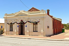 Pingelly Town Hall, 2014 | |||||||||||||||
 Location in Western Australia | |||||||||||||||
 | |||||||||||||||
| Population | 1,037 (LGA 2021)[1] | ||||||||||||||
| Established | 1891 | ||||||||||||||
| Area | 1,294.6 km2 (499.8 sq mi) | ||||||||||||||
| Shire President | William Mulroney | ||||||||||||||
| Council seat | Pingelly | ||||||||||||||
| Region | Wheatbelt | ||||||||||||||
| State electorate(s) | Central Wheatbelt | ||||||||||||||
| Federal division(s) | O'Connor | ||||||||||||||
| Website | Shire of Pingelly | ||||||||||||||
| |||||||||||||||
History edit
On 24 December 1891, the Morambine Road District was created. On 21 February 1913, it was renamed the Pingelly Road District. On 1 July 1961, it became a Shire following the passage of the Local Government Act 1960, which reformed all remaining road districts into shires.[2]
Wards edit
From 20 October 2007, Pingelly is no longer divided into wards, and its 8 councillors represent the entire shire.
The ward systems created under successive divisions were as follows:[2]
| 1921 | 1986 | 1992 | 2003 |
|---|---|---|---|
| Pingelly Ward (3) | Pingelly Ward (4) | Town Ward (4) | |
| Central Ward (2) | Mourambine Ward (1) | Hotham Ward (1) | Hotham Ward (2) |
| Noonebin Ward (1) | Jingaring Ward (1) | Jingaring Ward (2) | |
| North East Ward (1) | Kulyaling Ward (1) | Kulyaling Ward (2) | |
| North West Ward (1) | Tutanning Ward (1) | Tutanning Ward (2) | |
| South East Ward (1) | |||
| South West Ward (1) | |||
Towns and localities edit
The towns and localities of the Shire of Pingelly with population and size figures based on the most recent Australian census:[3][4]
| Locality | Population | Area | Map | |||||||||||||||||||||||||||||||||||||||||||||||||||||||||||||||||||||||||||||||||||||||||||||||||||||||
|---|---|---|---|---|---|---|---|---|---|---|---|---|---|---|---|---|---|---|---|---|---|---|---|---|---|---|---|---|---|---|---|---|---|---|---|---|---|---|---|---|---|---|---|---|---|---|---|---|---|---|---|---|---|---|---|---|---|---|---|---|---|---|---|---|---|---|---|---|---|---|---|---|---|---|---|---|---|---|---|---|---|---|---|---|---|---|---|---|---|---|---|---|---|---|---|---|---|---|---|---|---|---|---|---|---|---|
| East Pingelly | 211 (SAL 2021)[5] | 922.2 km2 (356.1 sq mi) | 
| |||||||||||||||||||||||||||||||||||||||||||||||||||||||||||||||||||||||||||||||||||||||||||||||||||||||
| Pingelly | 722 (SAL 2021)[6][7] | 12.5 km2 (4.8 sq mi) | West Pingelly | 100 (SAL 2021)[8] | 359.4 km2 (138.8 sq mi) |
Former towns
edit
Population edit
Notable councillors edit
Heritage-listed places editAs of 2023, 71 places are heritage-listed in the Shire of Pingelly,[9] of which one is on the State Register of Heritage Places, the Pingelly Post Office.[10] A second place on the register, the CBH Bins, Pingelly, was deregistered on 1 July 2021.[11]
Formerly on the State Register of Heritage Places:
References edit
External links edit
32°32′02″S 117°05′10″E / 32.534°S 117.086°E |
