


Summary
Sierra de Los Filabres is the largest mountain range in Almería Province, Andalusia, Spain, measuring 50 km (31 mi) in length.
| Sierra de Los Filabres | |
|---|---|
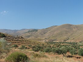 View of Sierra de Los Filabres | |
| Highest point | |
| Peak | Calar Alto |
| Elevation | 2,168 m (7,113 ft) |
| Coordinates | 37°13′25″N 02°32′46″W / 37.22361°N 2.54611°W |
| Geography | |
 Sierra de Los Filabres Location in Spain | |
| Location | Almería Province, Andalusia |
| Country | Spain |
| Parent range | Penibaetic System |
| Geology | |
| Mountain type | Schist and Quartzite |
Its highest point, the Calar Alto. is also the highest peak in the province of Almería and hosts an important astronomical observatory.[1]
Geography edit
The Sierra de Los Filabres belongs to the Penibaetic System and forms the southern limit of the Almanzora Valley. Besides its highest point, the 2,168 m high Calar Alto, other important peaks are the Tetica de Bacares or "La Tetica" (2,086 m), a breast-shaped hill,[2] and the Calar Gallinero (2,049 m).[3]
The Sierra de Los Filabres is an eastern prolongation of the Sierra de Baza mountain range in the same system. There are picturesque towns in this range, like Olula de Castro,[4] Chercos Viejo and Sierro, to name but a few. The easiest route to reach the range starts from Gérgal.[5]
See also edit
References edit
External links edit
- Parque Natural de la Sierra de los Filabres y comarca del Alto Almanzora
- Estación de Observación de Calar Alto (EOCA)
- Trekking World - Sierra de Los Filabres