


Summary
Silfiac (French pronunciation: [silfjak]; Breton: Silieg) is a commune in the Morbihan department of Brittany in north-western France.[3]
Silfiac
Silieg | |
|---|---|
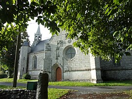 The Chapel of Saint-Laurent, in Silfiac | |
Location of Silfiac .mw-parser-output .locmap .od{position:absolute}.mw-parser-output .locmap .id{position:absolute;line-height:0}.mw-parser-output .locmap .l0{font-size:0;position:absolute}.mw-parser-output .locmap .pv{line-height:110%;position:absolute;text-align:center}.mw-parser-output .locmap .pl{line-height:110%;position:absolute;top:-0.75em;text-align:right}.mw-parser-output .locmap .pr{line-height:110%;position:absolute;top:-0.75em;text-align:left}.mw-parser-output .locmap .pv>div{display:inline;padding:1px}.mw-parser-output .locmap .pl>div{display:inline;padding:1px;float:right}.mw-parser-output .locmap .pr>div{display:inline;padding:1px;float:left}html.skin-theme-clientpref-night .mw-parser-output .od,html.skin-theme-clientpref-night .mw-parser-output .od .pv>div,html.skin-theme-clientpref-night .mw-parser-output .od .pl>div,html.skin-theme-clientpref-night .mw-parser-output .od .pr>div{background:#000;color:#fff}html.skin-theme-clientpref-night .mw-parser-output .locmap{filter:grayscale(0.6)}@media(prefers-color-scheme:dark){html.skin-theme-clientpref-os .mw-parser-output .locmap{filter:grayscale(0.6)}html.skin-theme-clientpref-os .mw-parser-output .od,html.skin-theme-clientpref-os .mw-parser-output .od .pv>div,html.skin-theme-clientpref-os .mw-parser-output .od .pl>div,html.skin-theme-clientpref-os .mw-parser-output .od .pr>div{background:#000;color:#fff}}  Silfiac  Silfiac | |
| Coordinates: 48°08′59″N 3°09′20″W / 48.1497°N 3.1556°W | |
| Country | France |
| Region | Brittany |
| Department | Morbihan |
| Arrondissement | Pontivy |
| Canton | Gourin |
| Intercommunality | Pontivy Communauté |
| Government | |
| • Mayor (2020–2026) | Olivier Constant[1] |
| Area 1 | 22.46 km2 (8.67 sq mi) |
| Population (2021)[2] | 483 |
| • Density | 22/km2 (56/sq mi) |
| Time zone | UTC+01:00 (CET) |
| • Summer (DST) | UTC+02:00 (CEST) |
| INSEE/Postal code | 56245 /56480 |
| Elevation | 175–276 m (574–906 ft) |
| 1 French Land Register data, which excludes lakes, ponds, glaciers > 1 km2 (0.386 sq mi or 247 acres) and river estuaries. | |
Geography edit
The village centre of Silfiac is the highest in the department of Morbihan. It is 270 meters above sea level. Silfiac is border by Séglien to the south, by Cléguérec and Sainte-Brigitte to the east, by Lescouët-Gouarec and Perret to the north and by Langoëlan to the west.
Map edit

Population edit
Inhabitants of Silfiac are called in French Silfiacois.
|
| ||||||||||||||||||||||||||||||||||||||||||||||||||||||||||||||||||||||||||||||||||||||||||||||||||||||||||||||||||
| Source: EHESS[4] and INSEE (1968-2020)[5] | |||||||||||||||||||||||||||||||||||||||||||||||||||||||||||||||||||||||||||||||||||||||||||||||||||||||||||||||||||
Prehistory edit
A six meters high standing stone called Quenouille du Diable (devil's distaff) rises in the town. It is one of the most imposing menhirs in Brittany.

History edit
The Rohans and the Fravals were the main lords of the parish. Their coats of arms are visible on the south wall of the Saint-Laurent chapel. The Fraval owned the manor of Crenihuel, in Silfiac.

See also edit
- Communes of the Morbihan department
- Gaston-Auguste Schweitzer Sculptor Silfiac war memorial
References edit
- ^ "Maires du Morbihan" (PDF). Préfecture du Morbihan. 7 July 2020.
- ^ "Populations légales 2021". The National Institute of Statistics and Economic Studies. 28 December 2023.
- ^ INSEE commune file
- ^ Des villages de Cassini aux communes d'aujourd'hui: Commune data sheet Silfiac, EHESS (in French).
- ^ Population en historique depuis 1968, INSEE
External links edit
- Base Mérimée: Search for heritage in the commune, Ministère français de la Culture. (in French)
- Mayors of Morbihan Association (in French)