
KNOWPIA
WELCOME TO KNOWPIA

Simonszand 
Summary
Simonszand (Dutch pronunciation: [ˈsimɔn(s)ˌsɑnt]) is a sandbank between the West Frisian Islands of Schiermonnikoog and Rottumerplaat in the Netherlands. It is located in the municipality of Het Hogeland in the province of Groningen.
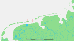 Location of Simonszand | |
| Geography | |
|---|---|
| Coordinates | 53°31′N 6°24′E / 53.517°N 6.400°E |
| Archipelago | (West) Frisian Islands |
| Adjacent to | North Sea Wadden Sea |
| Administration | |
Netherlands | |
| Province | Groningen |
| Municipality | Het Hogeland |
| Demographics | |
| Population | Uninhabited |
The sandbank was originally mapped as being an Intertidal zone in approximately 1811, but changed in later mappings to be shown as a Supratidal zone after it became larger and migrated seaward.[1]
References edit
External links edit
 Media related to Simonszand at Wikimedia Commons