
KNOWPIA
WELCOME TO KNOWPIA

Sint-Laureins 
Summary
Sint-Laureins (Dutch pronunciation: [sɪnt lʌu̯ˈrɛi̯ns]; Dutch for Saint Lawrence) is a municipality located in the Flemish province of East Flanders, in Belgium. The municipality comprises the towns of Sint-Jan-in-Eremo, Sint-Laureins proper, Sint-Margriete, Waterland-Oudeman and Watervliet. In 2021, Sint-Laureins had a total population of 6,919. The total area is 74.50 km2.[2]
Sint-Laureins | |
|---|---|
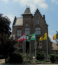 Sint-Laureins town hall | |
 Flag  Coat of arms | |
Location of Sint-Laureins .mw-parser-output .locmap .od{position:absolute}.mw-parser-output .locmap .id{position:absolute;line-height:0}.mw-parser-output .locmap .l0{font-size:0;position:absolute}.mw-parser-output .locmap .pv{line-height:110%;position:absolute;text-align:center}.mw-parser-output .locmap .pl{line-height:110%;position:absolute;top:-0.75em;text-align:right}.mw-parser-output .locmap .pr{line-height:110%;position:absolute;top:-0.75em;text-align:left}.mw-parser-output .locmap .pv>div{display:inline;padding:1px}.mw-parser-output .locmap .pl>div{display:inline;padding:1px;float:right}.mw-parser-output .locmap .pr>div{display:inline;padding:1px;float:left}html.skin-theme-clientpref-night .mw-parser-output .od,html.skin-theme-clientpref-night .mw-parser-output .od .pv>div,html.skin-theme-clientpref-night .mw-parser-output .od .pl>div,html.skin-theme-clientpref-night .mw-parser-output .od .pr>div{background:#000;color:#fff}html.skin-theme-clientpref-night .mw-parser-output .locmap{filter:grayscale(0.6)}@media(prefers-color-scheme:dark){html.skin-theme-clientpref-os .mw-parser-output .locmap{filter:grayscale(0.6)}html.skin-theme-clientpref-os .mw-parser-output .od,html.skin-theme-clientpref-os .mw-parser-output .od .pv>div,html.skin-theme-clientpref-os .mw-parser-output .od .pl>div,html.skin-theme-clientpref-os .mw-parser-output .od .pr>div{background:#000;color:#fff}}  Sint-Laureins Location in Belgium
Location of Sint-Laureins in East Flanders  | |
| Coordinates: 51°15′N 03°31′E / 51.250°N 3.517°E | |
| Country | |
| Community | Flemish Community |
| Region | Flemish Region |
| Province | East Flanders |
| Arrondissement | Eeklo |
| Government | |
| • Mayor | Franki Van de Moere (Samen Anders) |
| • Governing party/ies | Samen Anders |
| Area | |
| • Total | 74.54 km2 (28.78 sq mi) |
| Population (2018-01-01)[1] | |
| • Total | 6,684 |
| • Density | 90/km2 (230/sq mi) |
| Postal codes | 9980-9982, 9988 |
| NIS code | 43014 |
| Area codes | 09 |
| Website | www.sint-laureins.be |
The Our Lady-Church in Watervliet, built in the 16th century, is called the 'Cathedral of the North'.[3]
Gallery edit
-
 The Boerekreek is one of several lakes in Sint-Laureins
 -
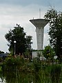 Water tower in Sint-Jan-in-Eremo
 -
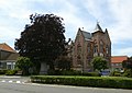 Townhall and freedom tree
 -
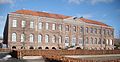 Godshuis. Nowadays hotel/restaurant


References edit
External links edit
 Media related to Sint-Laureins at Wikimedia Commons
- Official website (in Dutch)
- Official website of the youth council (in Dutch)