


Summary
The Sioux Area Metro (SAM) is the local governmental transit agency in Sioux Falls, South Dakota, and the state's largest public transportation operator. They provide multiple scheduled fixed routes and paratransit services. Although the city owns the bus fleet the system is currently managed by First Transit and operated under Sioux Area Metro. In 2023, the system had a ridership of 559,400, or about 1,800 per weekday as of the fourth quarter of 2023.
 | |
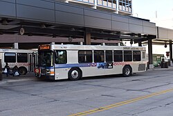 A SAM bus at the downtown terminal | |
| Headquarters | 500 E. Sixth St. Sioux Falls, South Dakota |
|---|---|
| Service area | Urban area |
| Service type | Bus service Tourist trolley Paratransit |
| Routes | 12 |
| Fleet | 29 Buses (Fixed Route) 26 Buses (Paratransit) |
| Daily ridership | 1,800 (weekdays, Q4 2023)[1] |
| Annual ridership | 559,400 (2023)[2] |
| Operator | First Transit |
| Website | siouxfalls |
Facilities edit
Transit Offices and Garage edit
- Address: 500 E. Sixth St.[3]
- Coordinates: 43°33′05.7″N 96°43′13.5″W / 43.551583°N 96.720417°W
- Facilities: Head office, bus storage and maintenance
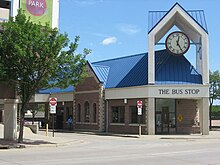
Sioux Area Metro Depot edit
- Address: 120 E. 11th St.
- Coordinates: 43°32′41.4″N 96°43′31.4″W / 43.544833°N 96.725389°W
- Facilities: Downtown bus terminal
The Sioux Area Metro Depot was originally built in 1988 and known as "The Bus Stop". In 2017, the facility underwent a $2 million renovation and reopened on November 6, 2017 with the name Sioux Area Metro Depot. The renovations included a skylight, new canopy, new benches, bike storage and bike repair station. The facility serves 11 routes. [4]
Southwest Transfer Facility edit
- Address: 4409 S. Louise Ave.
- Coordinates: 43°30′17″N 96°46′17″W / 43.50472°N 96.77139°W
- Facilities: Mall area bus terminal
Fixed routes edit
Effective February 1, 2016[5]
Routes operate Monday-Saturday unless otherwise indicated.
| No. | Destinations[6] | Notes |
|---|---|---|
| 1 | VA Hospital, South Kiwanis Ave | |
| 2 | Sanford Hospital, Augustana University, South Western Ave | |
| 3 | South Minnesota Ave, West 41st St, Empire Mall | |
| 4 | East 10th St | |
| 5 | Avera Hospital, South Cliff Ave, South Phillips Ave | |
| 6 | PREMIER Center, Terrace Park | |
| 7 | East Sioux Falls, Dawley Farms Village | |
| 8 | North 4th Ave, North Cliff Ave | Weekday Only |
| 9 | East 18th St, East 26th St | |
| 10 | West 12th St, Hayward Park, South Marion Rd | |
| 11 | Southwest Circulator | |
| 19 | University Center, Southeast Technical Institute, North Career Ave, Sioux Falls Bus Station | Weekday Only |
Discontinued Services edit
Sioux Area Metro operated an old-time trolley styled bus in the downtown area. In 2014 operation of the service was assumed by Downtown Sioux Falls Inc, and in 2019 they were joined by a coalition of local businesses to continue funding through 2022.[7]
Sioux Area Metro also operated four school "tripper" routes until May 2016. These routes were open to the public, with high schools as destinations. School Bus, Inc is currently operating those routes.[8]
Paratransit edit
Sioux Falls Paratransit is an extension to the city's fixed-route system, and persons with disabilities are encouraged to use it. Each paratransit bus is equipped with a wheelchair lift. All passengers must be certified by guidelines established by the Americans with Disabilities Act, and be registered with Sioux Area Metro after qualifying. Passengers must schedule Paratransit trips by calling their local office.[9]
Fixed route ridership and service edit
The ridership and service statistics shown here are of fixed route services only and do not include demand response. Per capita statistics are based on the Sioux Falls urbanized area as reported in NTD data. The significant changes in per capita numbers from 2010 to 2011 are a result of the 2010 census numbers replacing the 2000 census numbers.[10]
| Ridership | Change | Ridership per capita | Vehicle Revenue Hours | Change | Vehicle Revenue Hours per capita | |
|---|---|---|---|---|---|---|
| 2002 | 572,630 | n/a | 4.61 | 50,882 | n/a | 0.40945 |
| 2003 | 657,444 | 5.29 | 50,583 | 0.40704 | ||
| 2004 | 684,469 | 5.51 | 51,130 | 0.41145 | ||
| 2005 | 724,271 | 5.83 | 52,557 | 0.42293 | ||
| 2006 | 803,450 | 6.47 | 54,121 | 0.43551 | ||
| 2007 | 837,299 | 6.74 | 49,929 | 0.40178 | ||
| 2008 | 905,870 | 7.28 | 53,640 | 0.43164 | ||
| 2009 | 927,112 | 7.46 | 53,749 | 0.43252 | ||
| 2010 | 937,258 | 7.54 | 55,239 | 0.44451 | ||
| 2011 | 996,316 | 6.35 | 55,046 | 0.35111 | ||
| 2012 | 1,026,715 | 6.55 | 55,361 | 0.35312 | ||
| 2013 | 1,023,089 | 6.53 | 55,490 | 0.35394 | ||
| 2014 | 955,357 | 6.09 | 62,669 | 0.39973 | ||
| 2015 | 885,104 | 5.65 | 65,640 | 0.41868 | ||
| 2016 | 837,474 | 5.34 | 64,389 | 0.4107 | ||
| 2017 | 795,026 | 5.07 | 61,894 | 0.39479 | ||
| 2018 | 782,129 | 4.99 | 61,935 | 0.39505 | ||
| 2019 | 769,437 | 4.91 | 62,344 | 0.39766 | ||
| 2020 | 445,205 | 2.84 | 54,264 | 0.34612 | ||
| 2021 | 389,816 | 2.49 | 51,756 | 0.33012 | ||
| 2022 | 385,565 | 2.46 | - | - | - | |
| 2023 | 502,993 | 2.59 | - | - | - |
Fleet edit
2009 2015 2018 Gillig Low Floor
See also edit
References edit
- ^ "Transit Ridership Report Fourth Quarter 2023" (PDF). American Public Transportation Association. March 4, 2024. Retrieved March 14, 2024.
- ^ "Transit Ridership Report Fourth Quarter 2023" (PDF). American Public Transportation Association. March 4, 2024. Retrieved March 14, 2024.
- ^ Office
- ^ Joe Sneve (November 6, 2017). "Sioux Area Metro's downtown digs reopen after $2M worth of upgrades". Argus Leader. Retrieved June 27, 2022.
- ^ "Sioux Area Metro - City of Sioux Falls PDF Map of all SAM Routes, Shelters and Stops". www.siouxfalls.org. Retrieved 2018-04-15.
- ^ "City of Sioux Falls Bus Routes". Retrieved 2018-04-15.
- ^ Tuchscherer, Rebekah. "Downtown Sioux Falls Trolley saved for 2018 summer". Argus Leader. Retrieved 2020-10-26.
- ^ "Sioux Falls Transit Development Plan". Retrieved 2018-04-15.
- ^ "Paratransit Service - City of Sioux Falls". www.siouxfalls.org. Retrieved 2018-04-15.
- ^ "The National Transit Database (NTD)". Retrieved June 27, 2022.