


Summary
Sisikon is a municipality in the canton of Uri in Switzerland. It is situated on the shore of Lake Lucerne.
Sisikon | |
|---|---|
 | |
 Coat of arms | |
Location of Sisikon .mw-parser-output .locmap .od{position:absolute}.mw-parser-output .locmap .id{position:absolute;line-height:0}.mw-parser-output .locmap .l0{font-size:0;position:absolute}.mw-parser-output .locmap .pv{line-height:110%;position:absolute;text-align:center}.mw-parser-output .locmap .pl{line-height:110%;position:absolute;top:-0.75em;text-align:right}.mw-parser-output .locmap .pr{line-height:110%;position:absolute;top:-0.75em;text-align:left}.mw-parser-output .locmap .pv>div{display:inline;padding:1px}.mw-parser-output .locmap .pl>div{display:inline;padding:1px;float:right}.mw-parser-output .locmap .pr>div{display:inline;padding:1px;float:left}html.skin-theme-clientpref-night .mw-parser-output .od,html.skin-theme-clientpref-night .mw-parser-output .od .pv>div,html.skin-theme-clientpref-night .mw-parser-output .od .pl>div,html.skin-theme-clientpref-night .mw-parser-output .od .pr>div{background:#000;color:#fff}html.skin-theme-clientpref-night .mw-parser-output .locmap{filter:grayscale(0.6)}@media(prefers-color-scheme:dark){html.skin-theme-clientpref-os .mw-parser-output .locmap{filter:grayscale(0.6)}html.skin-theme-clientpref-os .mw-parser-output .od,html.skin-theme-clientpref-os .mw-parser-output .od .pv>div,html.skin-theme-clientpref-os .mw-parser-output .od .pl>div,html.skin-theme-clientpref-os .mw-parser-output .od .pr>div{background:#000;color:#fff}}  Sisikon 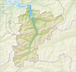 Sisikon | |
| Coordinates: 46°57′N 8°37′E / 46.950°N 8.617°E | |
| Country | Switzerland |
| Canton | Uri |
| District | n.a. |
| Area | |
| • Total | 16.46 km2 (6.36 sq mi) |
| Elevation | 453 m (1,486 ft) |
| Population (31 December 2018)[2] | |
| • Total | 369 |
| • Density | 22/km2 (58/sq mi) |
| Time zone | UTC+01:00 (Central European Time) |
| • Summer (DST) | UTC+02:00 (Central European Summer Time) |
| Postal code(s) | 6452 |
| SFOS number | 1217 |
| ISO 3166 code | CH-UR |
| Surrounded by | Bauen, Bürglen, Flüelen, Morschach (SZ), Riemenstalden (SZ), Seelisberg |
| Website | www SFSO statistics |
Geography edit

Sisikon has an area, as of 2006[update], of 16.3 km2 (6.3 sq mi). Of this area, 30.9% is used for agricultural purposes, while 44% is forested. Of the rest of the land, 1.2% is settled (buildings or roads) and the remainder (23.8%) is non-productive (rivers, glaciers or mountains).[3] In the 1993/97 land survey[update], 36.5% of the total land area was heavily forested, while 4.1% is covered in small trees and shrubbery. Of the agricultural land, 0.2% is used for farming or pastures, while 4.5% is used for orchards or vine crops and 26.3% is used for alpine pastures. Of the settled areas, 0.4% is covered with buildings, 0.2% is listed as parks and greenbelts and 0.6% is transportation infrastructure. Of the unproductive areas, 0.4% is unproductive standing water (ponds or lakes), 0.2% is unproductive flowing water (rivers), 7.7% is too rocky for vegetation, and 15.5% is other unproductive land.[4]
Spilauersee is located on an alp below Rossstock.
Demographics edit
Sisikon has a population (as of 31 December 2020) of 383.[5] As of 2007[update], 6.8% of the population was made up of foreign nationals. Over the last 10 years the population has decreased at a rate of -2.8%. Most of the population (as of 2000[update]) speaks German (96.0%), with Italian being second most common ( 1.4%) and Serbo-Croatian being third ( 1.1%).[3] As of 2007[update] the gender distribution of the population was 51.8% male and 48.2% female.[6]
In the 2007 federal election the FDP party received 75% of the vote.[3]
In Sisikon about 69.7% of the population (between age 25-64) have completed either non-mandatory upper secondary education or additional higher education (either university or a Fachhochschule).[3]
Sisikon has an unemployment rate of 0.36%. As of 2005[update], there were 24 people employed in the primary economic sector and about 12 businesses involved in this sector. 11 people are employed in the secondary sector and there are 4 businesses in this sector. 90 people are employed in the tertiary sector, with 16 businesses in this sector.[3]
The historical population is given in the following table:[7]
| year | population |
|---|---|
| 1970 | 309 |
| 1980 | 314 |
| 1990 | 319 |
| 2000 | 350 |
| 2005 | 390 |
| 2007 | 382 |
Transport edit
Sisikon is served by the Sisikon station, situated within the municipality and on the Gotthard railway. Sisikon can be accessed by road via the Axenstrasse.
References edit
- ^ a b "Arealstatistik Standard - Gemeinden nach 4 Hauptbereichen". Federal Statistical Office. Retrieved 13 January 2019.
- ^ "Ständige Wohnbevölkerung nach Staatsangehörigkeitskategorie Geschlecht und Gemeinde; Provisorische Jahresergebnisse; 2018". Federal Statistical Office. 9 April 2019. Retrieved 11 April 2019.
- ^ a b c d e Swiss Federal Statistical Office accessed 09-Sep-2009
- ^ Canton Uri - Ground use statistics (in German) accessed 8 September 2009
- ^ "Ständige und nichtständige Wohnbevölkerung nach institutionellen Gliederungen, Geburtsort und Staatsangehörigkeit". bfs.admin.ch (in German). Swiss Federal Statistical Office - STAT-TAB. 31 December 2020. Retrieved 21 September 2021.
- ^ Uri Population statistics (in German) accessed 8 September 2009
- ^ Uri in Numbers 2009/10 edition (in German) accessed 8 September 2009