


Summary
Sitka Seaplane Base (FAA LID: A29) is a public use seaplane base owned by and located in Sitka, a city and borough in the U.S. state of Alaska.[1] It is included in the National Plan of Integrated Airport Systems for 2011–2015, which categorized it as a general aviation facility.[2] This seaplane base is located near the Sitka Rocky Gutierrez Airport.
Sitka Seaplane Base | |||||||||||
|---|---|---|---|---|---|---|---|---|---|---|---|
 | |||||||||||
| Summary | |||||||||||
| Airport type | Public | ||||||||||
| Owner | City & Borough of Sitka | ||||||||||
| Serves | Sitka, Alaska | ||||||||||
| Elevation AMSL | 0 ft / 0 m | ||||||||||
| Coordinates | 57°03′08″N 135°20′46″W / 57.05222°N 135.34611°W | ||||||||||
| Map | |||||||||||
 A29 Location of airport in Alaska | |||||||||||
| Runways | |||||||||||
| |||||||||||
| Statistics (2006) | |||||||||||
| |||||||||||
As per Federal Aviation Administration records, the airport had 32 passenger boardings (enplanements) in calendar year 2008,[3] 22 enplanements in 2009, and 41 in 2010.[4]
Facilities and aircraft edit
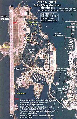
Sitka Seaplane Base has one seaplane landing area designated NW/SE with a water surface measuring 4,000 by 200 feet (1,219 x 61 m).[1] It is located on the Sitka Channel, between Japonski Island and Baranof Island.
For the 12-month period ending December 31, 2006, the airport had 4,750 aircraft operations, an average of 13 per day: 84% air taxi and 16% general aviation. At that time there were 9 aircraft based at this airport, all single-engine.[1]
Airlines and destinations edit
The following airline service is subsidized by the United States Department of Transportation via the Essential Air Service program.[5]
| Airlines | Destinations |
|---|---|
| Baranautica Air Service | Port Alexander[5] |
See also edit
- List of airports in Alaska
- Sitka Rocky Gutierrez Airport at coordinates 57°02′50″N 135°21′42″W / 57.04722°N 135.36167°W
References edit
- ^ a b c d FAA Airport Form 5010 for A29 PDF. Federal Aviation Administration. Effective May 31, 2012.
- ^ "2011–2015 NPIAS Report, Appendix A" (PDF, 2.03 MB). faa.gov. Federal Aviation Administration. October 4, 2010.
- ^ "Enplanements for CY 2008" (PDF, 1.0 MB). faa.gov. Federal Aviation Administration. December 18, 2009.
- ^ "Enplanements for CY 2010" (PDF, 189 KB). faa.gov. Federal Aviation Administration. October 4, 2011.
- ^ a b "Order 2021-9-13". U.S. Department of Transportation. September 23, 2021.
External links edit
- Harris Air
- Topographic map from USGS The National Map
- Resources for this airport:
- FAA airport information for A29
- AirNav airport information for A29
- FlightAware airport information and live flight tracker
- SkyVector aeronautical chart for A29