
KNOWPIA
WELCOME TO KNOWPIA

Sivrihisar 
Summary
Sivrihisar (Turkish: Sivrihisar, "a pointed castle") is a municipality and district of Eskişehir Province, Turkey.[2] Its area is 2,748 km2,[3] and its population is 20,087 (2022).[1] Its elevation is 1,070 m (3,510 ft).
Sivrihisar | |
|---|---|
District and municipality | |
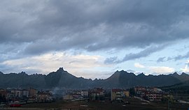 View of the town with mountain range in the background | |
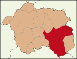 Map showing Sivrihisar District in Eskişehir Province | |
 Sivrihisar Location in Turkey  Sivrihisar Sivrihisar (Turkey Central Anatolia) | |
| Coordinates: 39°27′00″N 31°32′16″E / 39.45000°N 31.53778°E | |
| Country | Turkey |
| Province | Eskişehir |
| Government | |
| • Mayor | Hamid Yüzügüllü (AKP) |
| Area | 2,748 km2 (1,061 sq mi) |
| Elevation | 1,070 m (3,510 ft) |
| Population (2022)[1] | 20,087 |
| • Density | 7.3/km2 (19/sq mi) |
| Time zone | UTC+3 (TRT) |
| Postal code | 26600 |
| Area code | 0222 |
| Website | www |
Location edit
The town of Sivrihisar lies 13 km (8.1 mi) north of the historical site of Pessinus, at the foot of a high double-peaked ridge of granite, which bears the ruins of ancient Spaleia and a later Byzantine castle, which gives the town its name (sivri "sharp, pointed", hisar "fortress, castle"). It is located at the intersection of the E-90 and E-96 routes.
Economy edit
As of 1920, Sivrihisar was producing knitting clothing.[4]
Composition edit
There are 78 neighbourhoods in Sivrihisar District:[5]
- Ahiler
- Aktaş
- Aşağıkepen
- Aydınlı
- Babadat
- Bahçecik
- Ballıhisar
- Benlikuyu
- Benliyaver
- Beyyazı
- Biçer
- Böğürtlen
- Buhara
- Buzluca
- Camikebir
- Çandır
- Çaykoz
- Cumhuriyet
- Demirci
- Demirciköy
- Dinek
- Dumluca
- Dümrek
- Elcik
- Elmalı
- Ertuğrulköy
- Gedik
- Gerenli
- Göktepe
- Gülçayır
- Güvemli
- Hamamkarahisar
- Hızırbey
- Hüdavendigar
- İbikseydi
- İğdecik
- İlören
- İlyaspaşa
- İstiklalbağı
- Kadıncık
- Kaldırımköy
- Karabaşlı
- Karaburhan
- Karacakaya
- Karacalar
- Karacaören
- Karacaörenyaylası
- Karadat
- Karakaya
- Karkın
- Kaymaz
- Kertek
- Kılıç
- Kınık
- Koçaş
- Koltan
- Kubbeli
- Kurşunlu
- Kurtşeyh
- Memik
- Mülkköy
- Nasrettinhoca
- Oğlakçı
- Ortaklar
- Paşakadın
- Sadıkbağı
- Sarıkavak
- Selimiye
- Sığırcık
- Tekören
- Yaverören
- Yenice
- Yenidoğan
- Yeniköy
- Yeşilköy
- Yukarıkepen
- Yunusemre
- Zeyköyü
Notable natives edit
- Moushegh Ishkhan an Armenian poet, writer and educator.
- Nasreddin Hoca was born in Hortu village of Sivrihisar.[6]
- Yunus Emre was born in Sivrihisar.
Gallery edit
-
 Sivrihisar Clock Tower
 -
 Interior of the historical Grand Mosque of Sivrihisar
 -
 Backside view of the Holy Trinity Church, 1881
 -
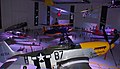 North American Aviation P-51 Mustang of the US Air Force and other airworthy aircraft on display in the M.S.Ö. Air & Space Museum


See also edit
References edit
- ^ a b "Address-based population registration system (ADNKS) results dated 31 December 2022, Favorite Reports" (XLS). TÜİK. Retrieved 12 July 2023.
- ^ Büyükşehir İlçe Belediyesi, Turkey Civil Administration Departments Inventory. Retrieved 12 July 2023.
- ^ "İl ve İlçe Yüz ölçümleri". General Directorate of Mapping. Retrieved 12 July 2023.
- ^ Prothero, G. W. (1920). Anatolia. London: H.M. Stationery Office. p. 112. Archived from the original on 2013-11-10.
- ^ Mahalle, Turkey Civil Administration Departments Inventory. Retrieved 12 July 2023.
- ^ Turkish Ministry of Culture and Tourism. "Life of Nasreddin Hoca" (in Turkish). Retrieved 2008-04-06.
External links edit
Wikivoyage has a travel guide for Sivrihisar.
- District governor's official website (in Turkish)
- Local guide to Sivrihisar (in Turkish and English)
- "General information on Sivrihisar, Eskişehir" (in Turkish). Governorship of Eskişehir, Turkey. Archived from the original on 2009-03-08.
- "Environmental Status Report for Eskişehir Province" (PDF) (in Turkish). Governorship of Eskişehir, Directorate of Provincial Environment and Forestry. 2006. Archived from the original (PDF) on 2009-03-05.