


Summary
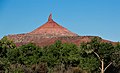
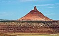
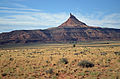
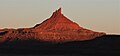
The Sixshooter Peaks are two iconic sandstone summits located in Bears Ears National Monument in San Juan County, Utah, United States.[2][3] The larger and higher North Sixshooter Peak rises to an elevation of 6,379 feet (1,944 meters), whereas South Sixshooter Peak rises to 6,154 feet, with approximately 1.5 miles (2.4 km) separation between the two.[4] These buttes tower nearly 1,400 feet (430 meters) above the surrounding terrain, and are historic landmarks visible from State Route 211 between Newspaper Rock and the Needles District of Canyonlands National Park. They are situated 1.5 mile outside the boundary of the park, and four miles northwest of Bridger Jack Butte. Variant names for the peaks include "North Six-Shooter Peak", "South Six-shooter Peak", "Six Shooter Peaks", and "Six-shooter Peak".[2] They are so named because of their resemblance to a pair of revolvers pointing skyward.[5]
| Sixshooter Peaks | |
|---|---|
 Six-shooter Peaks, east aspect | |
| Highest point | |
| Elevation | 6,379 ft (1,944 m)[1] |
| Prominence | 679 ft (207 m)[1] |
| Isolation | 4.37 mi (7.03 km)[1] |
| Coordinates | 38°08′15″N 109°40′05″W / 38.1375419°N 109.6681427°W[2] |
| Geography | |
 Sixshooter Peaks Location in Utah  Sixshooter Peaks Sixshooter Peaks (the United States) | |
| Location | Bears Ears National Monument San Juan County, Utah, US |
| Parent range | Colorado Plateau |
| Topo map | USGS North Six-shooter Peak and South Six-shooter Peak |
| Geology | |
| Age of rock | Late Triassic |
| Type of rock | Wingate Sandstone |
| Climbing | |
| First ascent | 1962 |
| Easiest route | class 5.7 climbing |
Geology edit
Sixshooter Peaks are composed of hard, fine-grained Wingate Sandstone, which is the remains of wind-borne sand dunes deposited approximately 200 million years ago in the Late Triassic. This Wingate sandstone forms steep cliffs as it overlays softer layers of the Chinle Formation which formed conical mounds beneath the Wingate towers.[5] The layer below this is Moenkopi Formation.[6] In the early 1980s, land surrounding South Sixshooter Peak was considered for the nation's first high-level nuclear waste repository, because thick salt beds 3,000 feet below the surface were potential host rocks for storing radioactive materials.[7][8] Precipitation runoff drains into nearby Indian Creek, which is part of the Colorado River drainage basin.
Climbing edit
The first ascent of North Sixshooter Peak was made April 14, 1962, by Maurice Horn, Huntley Ingalls, and Steve Komito via Southwest Chimney.[9] South Sixshooter Peak was first climbed in September 1969 by Billy Roos, Burnham Arndt, and Denver Collins. The popular south peak is a good climb for beginners and has one of the easiest tower routes in the Indian Creek climbing area.[10]
North Sixshooter Peak climbing routes edit
- Talk Dusty To Me class 5.9+[11]
- Southeast Chimney Route class 5.10 A1
- Liquid Sky class 5.11+
- Shadows Route class 5.10
- Gunsmoke class 5.11+
- Lightning Bolt Cracks class 5.11-
- Perfect Hands All the Way class 5.11+
- Pratt's Crack class 5.10
South Sixshooter Peak climbing routes edit
- South Face routes class 5.6 to 5.11
Climate edit
Spring and fall are the most favorable seasons to visit the Sixshooter Peaks. According to the Köppen climate classification system, they are located in a Cold semi-arid climate zone, which is defined by the coldest month having an average mean temperature below 32 °F (0 °C), and at least 50% of the total annual precipitation being received during the spring and summer. This desert climate receives less than 10 inches (250 millimeters) of annual rainfall, and snowfall is generally light during the winter.
Gallery edit
-
 North Sixshooter Peak, northeast aspect
 -
 South Sixshooter Peak
 -
 South Sixshooter (left), and North Peak to right
 -
 North Sixshooter Peak, northeast aspect
 -
 North Sixshooter Peak
 -
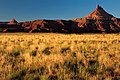
 North Sixshooter Peak at sunrise
 -
 Sixshooter Peaks from State Route 211
 -


See also edit
References edit
- ^ a b c "North Six-Shooter Peak - 6,379' UT". listsofjohn.com. Retrieved 2020-11-07.
- ^ a b c "North Sixshooter Peak". Geographic Names Information System. United States Geological Survey, United States Department of the Interior. Retrieved 2020-11-07.
- ^ "South Sixshooter Peak". Geographic Names Information System. United States Geological Survey, United States Department of the Interior. Retrieved 2020-11-07.
- ^ "South Six-Shooter Peak, Utah". Peakbagger.com. Retrieved 2020-11-07.
- ^ a b S.W. Lohman, The Geologic Story of Canyonlands National Park, US Government Printing Office, 1974, page 61.
- ^ J.H. Stewart, Stratigraphy and Origin of the Chinle Formation and Related Upper Triassic Strata in the Colorado Plateau Region, US Government Printing Office, 1972, page 296.
- ^ Sandra N. Eldredge, Canyon Country: A Geologic Guide to Canyonlands Travel Region, 1996.]
- ^ Iver Peterson, Utah Towns Debate Nuclear Wastes, New York Times, March 5, 1984.
- ^ "First Ascent Timeline". DesertTowersBook.
- ^ Stewart M. Green, Rock Climbing Utah, 2012, Morris Book Publishing, page 221.
- ^ North Six Shooter Peak Rock Climbing, Mountainproject.com
External links edit
- Weather Forecast: North Sixshooter Peak
- North Six Shooter Peak Rock Climbing: Mountainproject.com
- South Sixshooter Rock Climbing: Mountainproject.com
- Climbing Lightning Bolt Cracks, North Six Shooter: YouTube
- Climbing South Sixshooter: Vimeo