


Summary
Sobornyi District (Ukrainian: Соборний район) is an urban district of the city of Dnipro, in southern Ukraine.[3] It is located in the city's center on the right-bank of the Dnieper River.
Sobornyi District
Соборний район | |
|---|---|
 Coat of arms | |
| Coordinates: 48°27′00″N 35°04′00″E / 48.45000°N 35.06667°E | |
| Country | |
| Municipality | Dnipro Municipality |
| Established | 16 March 1936[1] |
| Government | |
| • Chairman of District Council | Anton Zhosul |
| Area | |
| • Total | 44.093 km2 (17.024 sq mi) |
| Population | |
| • Total | 167,645 |
| • Density | 3,800/km2 (9,800/sq mi) |
| Time zone | UTC+2 (EET) |
| • Summer (DST) | UTC+3 (EEST) |
| Area code | +380 562 |
| KOATUU | 1210136900[2] |
| Website | sobornarada |

|
History edit
According to archeological finds, in the Paleolithic period (7—3 thousand Anno Domini) human settlements appear on Monastyrskyi Island; which is located in Sobornyi District.[4] Traces of Cimmerian settlements during the Bronze Age have been found near today's Sobornyi District's Taras Shevchenko Park.[4]
The current district Sobornyi District was created on 16 March 1936 out of the Kirovskyi and Fabrychno-Chechelivskyi districts.[1] In 1973, a portion of its territory was annexed to the newly created Babushkinskyi District. Before 26 November 2015 the district was named Zhovtnevyi (Ukrainian: Жовтневий район); on that day the district was renamed to comply with decommunization laws.[5][6]
On 14 January 2023 a Russian missile destroyed a residential building on Sobornyi District's Naberezhna Peremohy St, 118; killing over 40 people.[7][8]
Population edit
Language edit
Distribution of the population by native language according to the 2001 census:[9]
| Language | Number | Percentage |
|---|---|---|
| Ukrainian | 66 009 | 39.37% |
| Russian | 99 665 | 59.45% |
| Other[a] | 1 971 | 1.18% |
| Total | 167 645 | 100.00% |
| a Those who did not indicate their native language or indicated a language that was native to less than 1% of the local population. |
Neighborhoods edit
- Nahirny
- Laherny
- Vuzivsky
- Mandrykivka
- Lotskamianka
- Peremoha
- Sokil
Gallery edit
-
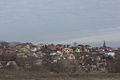 View of a part of Sobornyi District
 -
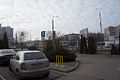 Peremoha microdistrict is a part of Sobornyi District
 -
 Sicheslav Embankment in Sobornyi district, Dnipro
 -
 Monastyrskyi Island with a church and steep cliffs
 -
![Panorama view of Nahirniy [uk] neighbourhood](//upload.wikimedia.org/wikipedia/commons/thumb/4/48/%D0%92%D0%B8%D0%B4_%D0%BD%D0%B0_%22%D0%9D%D0%B0%D0%B3%D1%96%D1%80%D0%BD%D1%83%22_%D1%87%D0%B0%D1%81%D1%82%D0%B8%D0%BD%D1%83_%D0%BC%D1%96%D1%81%D1%82%D0%B0_%D0%B7_%D0%BB%D1%96%D0%B2%D0%BE%D0%B3%D0%BE_%D0%B1%D0%B5%D1%80%D0%B5%D0%B3%D1%83.jpg/120px-%D0%92%D0%B8%D0%B4_%D0%BD%D0%B0_%22%D0%9D%D0%B0%D0%B3%D1%96%D1%80%D0%BD%D1%83%22_%D1%87%D0%B0%D1%81%D1%82%D0%B8%D0%BD%D1%83_%D0%BC%D1%96%D1%81%D1%82%D0%B0_%D0%B7_%D0%BB%D1%96%D0%B2%D0%BE%D0%B3%D0%BE_%D0%B1%D0%B5%D1%80%D0%B5%D0%B3%D1%83.jpg) Panorama view of Nahirniy neighbourhood
Panorama view of Nahirniy neighbourhood -
![Khrushchyovkas Science Avenue [uk; ru] (formerly Gagarin Avenue)[10]](//upload.wikimedia.org/wikipedia/commons/thumb/e/e0/%D0%9F%D1%80%D0%BE%D1%81%D0%BF._%D0%93%D0%B0%D0%B3%D0%B0%D1%80%D0%B8%D0%BD%D0%B0%2C_%D0%B4%D0%BE%D0%BC_99._-_panoramio.jpg/120px-%D0%9F%D1%80%D0%BE%D1%81%D0%BF._%D0%93%D0%B0%D0%B3%D0%B0%D1%80%D0%B8%D0%BD%D0%B0%2C_%D0%B4%D0%BE%D0%BC_99._-_panoramio.jpg)
-
![Firefighters putting out a fire at a residential building on Sobornyi District's Naberezhna Peremohy St [uk], 118, on 14 January 2023 after it was destroyed by a Russian Kh-22 missile](//upload.wikimedia.org/wikipedia/commons/thumb/d/d1/Dnipro_after_Russian_missile_attack%2C_2023-01-14_%2802-01%29.jpg/120px-Dnipro_after_Russian_missile_attack%2C_2023-01-14_%2802-01%29.jpg) Firefighters putting out a fire at a residential building on Sobornyi District's Naberezhna Peremohy St, 118, on 14 January 2023 after it was destroyed by a Russian Kh-22 missile
Firefighters putting out a fire at a residential building on Sobornyi District's Naberezhna Peremohy St, 118, on 14 January 2023 after it was destroyed by a Russian Kh-22 missile


![Panorama view of Nahirniy [uk] neighbourhood](http://upload.wikimedia.org/wikipedia/commons/thumb/4/48/%D0%92%D0%B8%D0%B4_%D0%BD%D0%B0_%22%D0%9D%D0%B0%D0%B3%D1%96%D1%80%D0%BD%D1%83%22_%D1%87%D0%B0%D1%81%D1%82%D0%B8%D0%BD%D1%83_%D0%BC%D1%96%D1%81%D1%82%D0%B0_%D0%B7_%D0%BB%D1%96%D0%B2%D0%BE%D0%B3%D0%BE_%D0%B1%D0%B5%D1%80%D0%B5%D0%B3%D1%83.jpg/120px-%D0%92%D0%B8%D0%B4_%D0%BD%D0%B0_%22%D0%9D%D0%B0%D0%B3%D1%96%D1%80%D0%BD%D1%83%22_%D1%87%D0%B0%D1%81%D1%82%D0%B8%D0%BD%D1%83_%D0%BC%D1%96%D1%81%D1%82%D0%B0_%D0%B7_%D0%BB%D1%96%D0%B2%D0%BE%D0%B3%D0%BE_%D0%B1%D0%B5%D1%80%D0%B5%D0%B3%D1%83.jpg)
![Khrushchyovkas Science Avenue [uk; ru] (formerly Gagarin Avenue)[10]](http://upload.wikimedia.org/wikipedia/commons/thumb/e/e0/%D0%9F%D1%80%D0%BE%D1%81%D0%BF._%D0%93%D0%B0%D0%B3%D0%B0%D1%80%D0%B8%D0%BD%D0%B0%2C_%D0%B4%D0%BE%D0%BC_99._-_panoramio.jpg/120px-%D0%9F%D1%80%D0%BE%D1%81%D0%BF._%D0%93%D0%B0%D0%B3%D0%B0%D1%80%D0%B8%D0%BD%D0%B0%2C_%D0%B4%D0%BE%D0%BC_99._-_panoramio.jpg)
![Firefighters putting out a fire at a residential building on Sobornyi District's Naberezhna Peremohy St [uk], 118, on 14 January 2023 after it was destroyed by a Russian Kh-22 missile](http://upload.wikimedia.org/wikipedia/commons/thumb/d/d1/Dnipro_after_Russian_missile_attack%2C_2023-01-14_%2802-01%29.jpg/120px-Dnipro_after_Russian_missile_attack%2C_2023-01-14_%2802-01%29.jpg)
References edit
- ^ a b "History of the Zhovtnevyi Raion". Council of the Zhovtnevyi Raion of the city of Dnipropetrovsk (in Ukrainian). Archived from the original on 2016-08-29. Retrieved 4 February 2015.
- ^ "Zhovtnevyi District Council". Informational portal of the self-government in Ukraine (in Ukrainian). Rada.info. Retrieved 5 February 2015.
- ^ "Zhovtnevyi Raion, Dnipropetrovsk Oblast, City of Dnipropetrovsk". Regions of Ukraine and their Structure (in Ukrainian). Verkhovna Rada of Ukraine. Retrieved 4 February 2015.
- ^ a b Yuri Pakhomenkov (2000). "History of Nadporizhe - Prydniprovye (from the first people to the 17th century)". gorod.dp.ua (in Ukrainian). Retrieved 16 October 2022.
- ^ (in Ukrainian) Street signs were Dnipropetrovsk nedekomunizovanymy, Radio Svoboda (2 December 2015)
- ^ "In Dnepropetrovsk, the main highways and five districts of the city were renamed" (in Ukrainian). depo.ua. Retrieved 27 November 2015.
- ^ Viktoriia Roshchyna (15 January 2023). ""Hatred for Russia is stronger than fear". A report from Dnipro, where Russian forces attacked an apartment block". Ukrainska Pravda. Retrieved 16 January 2023.
- ^ "Attack on Dnipro: death toll rises to 40 people". Ukrainska Pravda. 2023-01-16. Retrieved 16 January 2023.
- ^ "Рідні мови в об'єднаних територіальних громадах України" (in Ukrainian).
- ^ Stas Rudenko (23 January 2024). "Gagarin, Titov, Sofia Kovalevska and more than 90 streets and alleys are going to be renamed in Dnipro". Informator (in Ukrainian). Retrieved 23 February 2024.
External links edit
- Official website (in Ukrainian)