


Summary
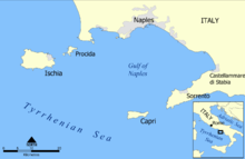
The Sorrento Peninsula or Sorrentine Peninsula is a peninsula located in southern Italy which separates the Gulf of Naples to the north from the Gulf of Salerno to the south.


Geography edit
Overview edit
The peninsula is named after its main town, Sorrento, which is located on the north (Gulf of Naples) coast. The Amalfi Coast is located on the southern side.[1] The Lattari Mountains form the geographical backbone of the peninsula. The island of Capri lies off the western tip of the peninsula in the Tyrrhenian Sea. The whole area is an important tourist destination.[2]
Municipalities edit
9 comunes of the peninsula are in the territory of the province of Naples and 12 comunes are in the province of Salerno.

|
Transportation edit
Airports edit
![]() The nearest airports are:
The nearest airports are:
- Naples International (NAP)
- Salerno Costa d'Amalfi (QSR)
See also edit
References edit
External links edit
![]() Media related to Sorrento Peninsula at Wikimedia Commons
Media related to Sorrento Peninsula at Wikimedia Commons
40°37′29″N 14°25′00″E / 40.6246°N 14.4168°E