


Summary
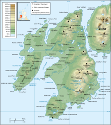
The Sound of Islay (Scottish Gaelic: Caol Ìle) is a narrow strait between the islands of Islay and Jura off the west coast of Scotland. It is about 30 kilometres (20 miles) in extent from north to south and lies between Rubh' a' Mhàil on Islay and Rubh' Aird na Sgitheich on Jura to the north and Macarthur's Head and Rubha na Tràille to the south. The islands in the Sound are Am Fraoch Eilean, Brosdale Island and Glas Eilean, all of which are off the south east coast of Jura. These islands, Jura south of Loch Tarbert and the eastern part of the Sound are one of 40 National Scenic Areas in Scotland.[1]
History edit
Am Fraoch Eilean (meaning "heather isle") contains the ruins of the medieval stronghold Claig Castle. It was built by Somerled in 1154 to defend the Sound and later used as a prison. Unusually for the Argyll islands the design, which is a Norman square tower with 3-metre-thick (10-foot) walls, is similar in style to mainland castles of the period.[2][3] The Sound has been suggested as the location of the 1156 Battle of Epiphany.[4]
In 1549 Dean Monro wrote: "At the mouth of Kyle Ila, betwixt it and Duray, lyes ane ile, callit in Erische Leid Ellan Charne, in English the iyle of Earne".[5] This may refer to Eilean a' Chùirn at NR472489.[6]
Ferry edit
Argyll and Bute Council operate a vehicle and passenger ferry service across the Sound from Feolin slipway on the west coast of Jura to Port Askaig on Islay, and Caledonian MacBrayne operate a vehicle and passenger ferry between Port Askaig and Kennacraig, on the mainland in West Loch Tarbert.
Renewable energy edit

In March 2011, the Scottish Government approved the largest tidal array in the world for the Sound of Islay, with 10 planned tidal turbines predicted to generate enough power for over 5,000 homes. The site offers both high currents and shelter from storms.[7]
Notes edit
- ^ "National Scenic Areas" Archived 2017-03-11 at the Wayback Machine. SNH. Retrieved 30 Mar 2011.
- ^ Haswell-Smith (2004) pp. 50-51
- ^ RCAHMS (1984) p. 36
- ^ Marsden (2008) p.84
- ^ Monro (1549) "Earne Isle" No. 56
- ^ In Scottish Gaelic cùirn is the genitive of càrn. Translation from Scots: "At the mouth of the Straits of Islay, between it and Jura, lies an island, called in the Gaelic language Ellan Charne, which is in English the Isle of Earne".
- ^ "Islay to get major tidal power scheme" (March 17, 2011) BBC Scotland. Retrieved 17 March 2011.
References edit
- Haswell-Smith, Hamish (2004). The Scottish Islands. Edinburgh: Canongate. ISBN 978-1-84195-454-7.
- Marsden, John (2008) Somerled and the Emergence of Gaelic Scotland. Birlinn. East Linton. First published, 2000.
- Monro, Sir Donald (1549) Description of the Western Isles of Scotland. William Auld. Edinburgh - 1774 edition.
- RCAHMS (1984) Argyll: Islay, Jura, Colonsay & Oronsay.
External links edit
55°51′N 6°06′W / 55.85°N 6.10°W