


Summary
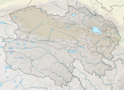
South or Nan Hulsan Lake, also known by other names, is a lake northeast of Golmud in Dulan County, Haixi Prefecture, Qinghai Province, China. A part of the Qarhan Playa, it lies east of Tuanjie Lake and south of North Hulsan Lake. Like the other lakes of the surrounding Qaidam Basin, it is extremely saline.
| South Hulsan Lake | |
|---|---|
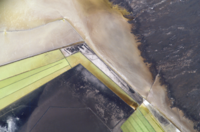
 The Qarhan Playa (1975), with South Hulsan in the southeast corner | |
 South Hulsan Lake | |
| Location | Dulan County Haixi Prefecture Qinghai Province China |
| Coordinates | 36°43′54″N 95°48′23.5″E / 36.73167°N 95.806528°E |
| Type | Endorheic saline lake |
| Primary inflows | Nuomuhong River Suolinguole River |
| Basin countries | China |
| Surface area | 33.41 km2 (12.90 sq mi) |
| Surface elevation | 2,675.6 m (8,780 ft) |
| South Hulsan Lake | |||||||||
|---|---|---|---|---|---|---|---|---|---|
| South Huobuxun | |||||||||
| Traditional Chinese | 南霍布遜湖 | ||||||||
| Simplified Chinese | 南霍布逊湖 | ||||||||
| |||||||||
| South Huoluxun | |||||||||
| Traditional Chinese | 南霍魯遜湖 | ||||||||
| Simplified Chinese | 南霍鲁逊湖 | ||||||||
| Literal meaning | South Hulsan Lake | ||||||||
| |||||||||
| Mongolian name | |||||||||
| Mongolian script | ᠡᠮᠦᠨᠡ ᠬᠤᠯᠤᠰᠤ ᠨᠠᠭᠤᠷ | ||||||||
| |||||||||
Name edit
Hulsan[1][2][3] or Hollusun Nor[4] is a romanization of a Mongolian name meaning "Reed Lake", from their former abundance in the area.[5] The adjective "south" distinguishes it from nearby North Hulsan Lake.[5] Huoluxun and Huobuxun[a] are the pinyin romanizations of the Mandarin pronunciation of the same name's transcriptions into Chinese characters. Nan Hulsan or Nanhuobuxun[2] is the same name, prefixed with the Chinese word for "South".
Geography edit
South Hulsan Lake lies in the southern Hulsan subbasin[9] at the eastern edge of the Qarhan Playa in the southeastern corner of the Qaidam Basin[10][7] at an elevation of 2,675.6 m (8,780 ft).[11] It lies east of Tuanjie Lake and south of North Hulsan Lake.[9] It is fed from the east by the Nuomuhong (t 諾木洪河, s 诺木洪河, Nuòmùhóng Hé) and Sulinggele[12] or Suolinguole River.[13]
It usually has an area of 33.41 km2 (13 sq mi),[11] but it varies widely during and between years. It usually increases from the winter and spring floods and decreases during the summer and autumn. In 2014, it was as small as 11.33 km2 (4 sq mi) and as wide as 91.94 km2 (35 sq mi).[3] In the especially dry year of 2000, it was only 0.51 km2 (0.2 sq mi).[14] An inflow from the north by mineral springs in the playa's northern karst zone contribute a smaller volume of water[2] but its much higher solute concentration greatly affects the lake and its sediments.[15][16] In the area's hyperarid climate, there is generally only 28–40 mm (1–2 in) of annual rainfall but about 3,000 mm (120 in) of annual evaporation.[2] It is never more than about 1 m (3 ft 3 in) deep.[2]
History edit
South Hulsan Lake has gained somewhat since the year 2000 as North Hulsan has shrunk in size to ephemeral status; this is thought to be related to the many salt pans constructed in recent years to harvest the lakes' sediment for potash.[14]
Gallery edit


See also edit
Notes edit
References edit
Citations edit
- ^ Zheng (1997), p. 41.
- ^ a b c d e Yu & al. (2001), p. 62.
- ^ a b Zhou & al. (2016), p. 4.
- ^ Gross (1935).
- ^ a b Jia (2019).
- ^ Spencer & al. (1990), p. 399.
- ^ a b Lowenstein & al. (2009), p. 75.
- ^ Garrett (1996), p. 177.
- ^ a b Du & al. (2018), pp. 2–3.
- ^ Spencer & al. (1990), p. 396.
- ^ a b Zheng (1997), p. 16
- ^ Huang & al. (1997), p. 271.
- ^ Du & al. (2018), p. 2.
- ^ a b Zhou & al. (2016), p. 6.
- ^ Spencer & al. (1990), pp. 398–399.
- ^ Lowenstein & al. (2009), p. 78.
Bibliography edit
- Du Yongsheng; et al. (April 2018), "Evalutation of Boron Isotopes in Halite as an Indicator of the Salinity of Qarhan Paleolake Water in the Eastern Qaidam Basin, Western China", Geoscience Frontiers, vol. 10, Beijing: China University of Geosciences, pp. 1–10, doi:10.1016/j.gsf.2018.02.016.
- Garrett, Donald Everett (1996), Potash: Deposits, Processing, Properties, and Uses, London: Chapman & Hall, ISBN 9789400915459.
- Gross, Alexander (1935), "China and Adjacent States", Geographia Atlas of the World, New York: Geographia Map Co.
- Huang Qi; et al. (1997), "Stable Isotopes Distribution in Core Ck6 and Variations of Paleoclimate over Qarhan Lake Region in Qaidam Basin, China", Chinese Journal of Oceanology and Limnology, vol. 15, Beijing: Science Press, pp. 271–278, doi:10.1007/BF02850884, S2CID 129491899.
- Jia Xiru (20 February 2019), "Qīnghǎi Měnggǔyǔ Dìmíng de Jǐge Tèsè 青海蒙古語地名的幾個特色 [Several Characteristics of Mongolian Placenames in Qinghai]", Xuěhuā Xīnwén 雪花新闻 [Snowflake News] (in Chinese).
- Lowenstein, Timothy K.; et al. (2009), "Closed Basin Brine Evolution and the Influence of Ca–Cl Inflow Waters: Death Valley and Bristol Dry Lake, California, Qaidam Basin, China, and Salar de Atacama, Chile", Aquatic Geochemistry, vol. 15, Springer, pp. 71–94, doi:10.1007/s10498-008-9046-z, S2CID 129168176.
- Spencer, Ronald James; et al. (1990), "Origin of Potash Salts and Brines in the Qaidam Basin, China" (PDF), Fluid-Mineral Interactions: A Tribute to H.P. Eugster, Special Publication No. 2, Geochemical Society.
- Yu Ge; et al. (2001), Lake Status Records from China: Data Base Documentation (PDF), MPI-BGC Tech Rep, No. 4, Jena: Max Planck Institute for Biogeochemistry.
- Zheng Mianping (1997), An Introduction to Saline Lakes on the Qinghai–Tibet Plateau, Dordrecht: Kluwer Academic Publishers, ISBN 9789401154581.
- Zhou Shilun; et al. (2016), "Spatial-Temporal Variations and Their Dynamics of the Saline Lakes in the Qaidam Basin over the Past 40 Years", Earth and Environmental Science, IOP Conference Series, vol. 46, Bristol: IOP Publishing, doi:10.1088/1755-1315/46/1/012043.