


Summary
Southwest Alentejo and Vicentine Coast Natural Park (PNSACV) is a natural park located in southwest Portugal. It occupies an area of 895.7 km2 (345.8 sq mi) (605.8 km2 (233.9 sq mi) on land and 289.9 km2 (111.9 sq mi) at sea) and is one of the last strongholds of the wild European coast.[3] It has one of the highest levels of biodiversity in the country with over 12 endemic species of plant[4] and several bird nesting sites.
| Southwest Alentejo and Vicentine Coast Natural Park | |
|---|---|
IUCN category V (protected landscape/seascape) | |
 | |
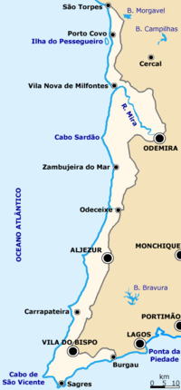 Map of the land area of the park in the southwest corner of Portugal | |
| Location | Alentejo Litoral & Barlavento Algarvio, Portugal |
| Coordinates | 37°27′23″N 8°47′19″W / 37.45639°N 8.78861°W |
| Area | 895.7 km2 (345.8 sq mi)[1] |
| Created | July 7, 1988 |
| Visitors | 12,718 (in 2017-2020 (average))[2] |
| Governing body | ICNF |
The park was created on 7 July 1988 in order to promote the protection and sustainable use of natural resources and other natural, landscape and cultural values while promoting the economic, social and cultural development of the region.[5] Since the last decade, the region has been marked by the expansion of intensive agriculture, either sanctioned or actively promoted by the government via the passing of laws that encourage the creation of new greenhouses to grow crops for the export market, dependant on labour that is often exploited, working in living in precarious conditions, and that damages local fauna, flora and water resources.[6][7][8]
The Rota Vicentina is a network of hiking and cycling trails that crosses the Southwest Alentejo and Vicentine Coast Natural Park.[9] Two routes of the Rota Vicentina are especially popular:
- The Trilho dos Pescadores or Fishermen's Trail between Porto Covo and Lagos. It's a 226,5 km coastal trail over sandy terrain, divided into 13 legs, with moderate difficulty.[10]
- The Caminho Histórico or Historical Way between Vale Seco and Cabo de San Vicente. It's a 263 km trail over rural roads and a classic Grand Route (GR), divided into 13 legs, that's easy to hike.[11] It has twice (2016 and 2020) been certified with the "Leading Quality Trails—Best of Europe" label by the ERA – European Ramblers Association.[12]
References edit
- ^ "Sudoeste Alentejano E Costa Vicentina | DOPA Explorer". dopa-explorer.jrc.ec.europa.eu. Retrieved 31 May 2021.
- ^ "Número de visitantes que contactaram as áreas protegidas". ICNF. Retrieved 31 May 2021.
- ^ Bastos, Maria Rosário; Dias, João A.; Baptista, Manuela; Batista, Carla (March 2012). "Ocupação do Litoral do Alentejo, Portugal: passado e presente". Revista de Gestão Costeira Integrada. 12 (1): 99–116. doi:10.5894/rgci307. ISSN 1646-8872. Retrieved 31 May 2021.
- ^ "Sudoeste Alentejano e Costa Vicentina Nature Park". natural.pt. Retrieved 31 May 2021.
- ^ "Decreto-Lei 241/88, 1988-07-07" (in Portuguese). Diário da República. Retrieved 31 May 2021.
- ^ Slavery in the Alentejo - Portugal Resident
- ^ Outrage as Government Accused of Allowed Even more Plastic Greehouses into Costa Vicentina Natural Park - Portugal Resident
- ^ Plastic Greenhouses Out of Control in Costa Vicentina Natural Park
- ^ "Costa Vicentina". CosmopoliClan. 23 February 2021. Retrieved 15 April 2024.
- ^ "Fishermen's Trail". Rota Vicentina. Retrieved 2024-04-15.
- ^ "Historical Way". Rota Vicentina. Retrieved 2024-04-15.
- ^ "Leading Quality Trails - Best of Europe | ERA". European Ramblers Association. Retrieved 2024-04-15.
External links edit
- Maria Rosário Bastos; João A. Dias; Manuela Baptista; Carla Batista (March 2012), "Human Occupation of Littoral of Alentejo, Portugal: past and present", Revista de Gestão Costeira Integrada, 12 (1), SciELO: 99–116, doi:10.5894/rgci307, retrieved 2 January 2021