


Summary
Split-Dalmatia County (Croatian: Splitsko-dalmatinska županija [splîtsko-dalmǎtiːnskaː ʒupǎnija]) is a central-southern Dalmatian county in Croatia. The administrative center is Split. The population of the county is 455,242 (2011). The land area is 14.106,40 km2.[4] Split-Dalmatia County is Croatia's most rapidly urbanising and developing region, as economic opportunities and living standards are among the highest alongside capital Zagreb and Istria County.
Split-Dalmatia County
Splitsko-dalmatinska županija | |
|---|---|
           | |
 Flag  Coat of arms | |
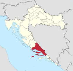 Split-Dalmatia County within Croatia | |
| Country | Croatia |
| County seat | Split |
| Government | |
| • Župan | Blaženko Boban (HDZ) |
| Area | |
| • Total | 14,106.40 km2 (5,446.51 sq mi) |
| Population (2011)[2] | |
| • Total | 454,798 |
| • Density | 32/km2 (84/sq mi) |
| Area code | 021 |
| ISO 3166 code | HR-17 |
| HDI (2019) | 0.843[3] very high · 5th |
| Website | http://www.dalmacija.hr |
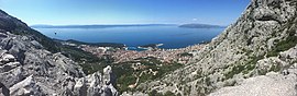
Physically, the county is divided into three main parts: an elevated hinterland (Dalmatinska zagora) with numerous karst fields; a narrow coastal strip with high population density; and the islands. Parts of the Dinaric Alps, including Dinara itself, form the border with Bosnia and Herzegovina while the Kozjak, Mosor and Biokovo mountains separate the coastal strip from the hinterland.
Important economic activities include agriculture, manufacturing and fishing, though the most important one is tourism.
Split-Dalmatia County is Croatia's biggest county by area.
The county is linked to the rest of Croatia by the newly built four-lane Split-Zadar-Karlovac-Zagreb highway and the Lika railway. Split Airport is the busiest airport in the region.
In the hinterland, the larger towns are Sinj (pop. 11,500 town, 25,373 with villages), Imotski (4,350) and Vrgorac (2,200).
Besides the largest city, Split (189,000 city proper, 250,000 including Kaštela and Solin), the towns on the coast are Trogir (11,000), Omiš (6,500) and Makarska (13,400).
On the islands, the populations are smaller due to high levels of emigration, but are still mostly urban in character. The main townships are: Supetar (3,300) on the island of Brač; Hvar town (3,700) and Stari Grad (1,900) on Hvar; and Vis town (1,800) and Komiža (1,500) on Vis.
History edit
The name Dalmatia comes from an Illyrian tribe called the Dalmatae who inhabited the area of the eastern Adriatic coast in the 1st millennium BC. It was part of the Illyrian kingdom from the 4th century BC until the Illyrian Wars in the 220s BC and 168 BC when the Roman Republic established its protectorate south of the river Neretva. Dalmatia as a geographical name was in use probably from the second half of the 2nd century BC for the area spanning the eastern Adriatic coast between the Krka and Neretva rivers.[5][6] It was slowly incorporated into Roman possessions until the province of Illyricum was formally established c. 32–27 BC.
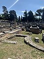
Dalmatia became part of the Roman province of Illyricum. In 9 AD, the Dalmatians raised the final of a series of revolts[7] together with the Pannonians, but it was finally crushed, and in 10 AD, Illyricum was split into two provinces, Pannonia and Dalmatia which spread into larger area inland to cover all of the Dinaric Alps and most of the eastern Adriatic coast.[8] Dalmatia was the birthplace of the Roman Emperor Diocletian, who constructed Diocletian's Palace in the core of what is now Split.[9]
Administrative division edit
Split-Dalmatia County is divided into 16 cities and 39 municipalities. Note that both cities and municipalities are administrative divisions immediately under the county, on the same level.
| Town / municipality | Population[10] (2011 census) |
Area (km2) | |
|---|---|---|---|
| Hvar | 4,251 | 75.50 | |
| Imotski | 10,764 | 73.25 | |
| Kaštela | 38,667 | 57.67 | |
| Komiža | 1,526 | 48.00 | |
| Makarska | 13,834 | 28.00 | |
| Omiš | 14,936 | 266.20 | |
| Sinj | 24,826 | 181.00 | |
| Solin | 23,926 | 18.37 | |
| Split | 178,102 | 79.33 | |
| Stari Grad | 2,781 | 52.59 | |
| Supetar | 4,074 | 30.00 | |
| Trilj | 9,109 | 267.00 | |
| Trogir | 13,192 | 39.10 | |
| Vis | 1,934 | 52.00 | |
| Vrgorac | 6,572 | 284.00 | |
| Vrlika | 2,177 | 243.00 | |
| Baška Voda | 2,775 | 19.00 | |
| Bol | 1,630 | 23.00 | |
| Brela | 1,703 | 20.00 | |
| Cista Provo | 2,335 | 98.00 | |
| Dicmo | 2,802 | 68.00 | |
| Dugi Rat | 7,092 | 10.80 | |
| Dugopolje | 3,469 | 63.50 | |
| Gradac | 3,261 | 49.00 | |
| Hrvace | 3,617 | 210.00 | |
| Jelsa | 3,582 | 146.28 | |
| Klis | 4,801 | 176.10 | |
| Lećevica | 583 | 87.66 | |
| Lokvičići | 807 | 31.11 | |
| Lovreć | 1,699 | 105.25 | |
| Marina | 4,595 | 108.80 | |
| Milna | 1,034 | 35.00 | |
| Muć | 3,882 | 210.80 | |
| Nerežišća | 862 | 79.00 | |
| Okrug | 3,349 | 9.80 | |
| Otok | 5,474 | 95.00 | |
| Podbablje | 4,680 | 41.76 | |
| Podgora | 2,518 | 52.00 | |
| Podstrana | 9,129 | 11.52 | |
| Postira | 1,559 | 47.00 | |
| Prgomet | 673 | 77.23 | |
| Primorski Dolac | 770 | 31.23 | |
| Proložac | 3,802 | 85.60 | |
| Pučišća | 2,171 | 106.00 | |
| Runovići | 2,416 | 60.21 | |
| Seget | 4,854 | 77.90 | |
| Selca | 1,804 | 53.00 | |
| Sućuraj | 463 | 44.65 | |
| Sutivan | 822 | 22.00 | |
| Šestanovac | 1,958 | 88.90 | |
| Šolta | 1,700 | 58.98 | |
| Tučepi | 1,931 | 16.00 | |
| Zadvarje | 289 | 13.40 | |
| Zagvozd | 1,188 | 124.09 | |
| Zmijavci | 2,048 | 13.82 | |
| Split-Dalmatia total | 455,798 | 4,572.00 | |
County government edit
Current Župan (prefect): Blaženko Boban (HDZ)
The county assembly is composed of 51 representatives. After the 2021 election the newly elected composition was as follows:[11]
- Croatian Democratic Union (HDZ): 18
- The Bridge (Most): 7
- Social Democratic Party of Croatia (SDP): 6
- Coalition "FOR" (ZA): 5
- Croatian Social Liberal Party (HSLS)
- Independent Youth List (NLM)
- Smart for Split and Dalmatia (Pametno)
- Centre (CENTAR): 4
- Croatian Civic Party (HGS): 4
- Homeland Movement (DP): 3
Demographics edit

|
| |||||||||||||||||||||||||||||||||||||||||||||||||||||||||
| census data [1] | ||||||||||||||||||||||||||||||||||||||||||||||||||||||||||
According to the 2011 census, Split-Dalmatia County has population of 454,798. Croats make up an absolute majority with 97.08% of the population.[2]
| population | 164242 | 182405 | 195741 | 222030 | 249867 | 268187 | 274522 | 292321 | 296840 | 314933 | 339686 | 389277 | 436680 | 474019 | 463676 | 454798 | 425412 |
| 1857 | 1869 | 1880 | 1890 | 1900 | 1910 | 1921 | 1931 | 1948 | 1953 | 1961 | 1971 | 1981 | 1991 | 2001 | 2011 | 2021 |
Economy edit
Split-Dalmatia County has the 5th highest Human Development Index of any county in Croatia. Before privatisation and accession to European Union, beside tourism the most notable branch was Shipbuilding. County now relies on tourism as main source of income.
Footnotes edit
- ^ Ostroški, Ljiljana, ed. (December 2015). Statistički ljetopis Republike Hrvatske 2015 [Statistical Yearbook of the Republic of Croatia 2015] (PDF). Statistical Yearbook of the Republic of Croatia (in Croatian and English). Vol. 47. Zagreb: Croatian Bureau of Statistics. p. 62. ISSN 1333-3305. Retrieved 27 December 2015.
- ^ a b "Population by Ethnicity, by Towns/Municipalities, 2011 Census: County of Split-Dalmatia". Census of Population, Households and Dwellings 2011. Zagreb: Croatian Bureau of Statistics. December 2012.
- ^ "Sub-national HDI - Area Database - Global Data Lab". hdi.globaldatalab.org. Retrieved 2021-07-19.
- ^ "Splitsko-dalmatinska županija > Županija > Informacije".
- ^ S. Čače, Ime Dalmacije u 2. i 1. st. Prije Krista
- ^ Radovi Filozofskog Fakulteta u Zadru, godište 40 za 2001. Zadar, 2003, pages 29,45.
- ^ Charles George Herbermann, The Catholic Encyclopedia: An International Work of Reference (1913)
- ^ M. Zaninović, Ilirsko pleme Delmati, pages 58, 83-84.
- ^ "Michael Hogan, "Diocletian's Palace", The Megalithic Portal, ed. Andy Burnham, Oct 6, 2007".
- ^ "Population by Age and Sex, by Settlements, 2011 Census: County of Split-Dalmatia". Census of Population, Households and Dwellings 2011. Zagreb: Croatian Bureau of Statistics. December 2012.
- ^ "LOKALNI IZBORI (16.05.2021.)". izbori.hr (Državno izborno povjerenstvo) (in Croatian). Retrieved 7 April 2024.
External links edit
- County web site (in Croatian)
- Dalmatia.iNFO - Dalmatia travel portal
- Split Dalmatia County tourist guide in English
43°10′N 16°30′E / 43.167°N 16.500°E