
KNOWPIA
WELCOME TO KNOWPIA

Spring Valley State Park 
Summary
Spring Valley State Park is a public recreation area adjoining the 65-acre (26 ha) Eagle Valley Reservoir in eastern Nevada near the border with the state of Utah. The state park is located at the east end of Nevada State Route 322, 20 miles (32 km) east of the town of Pioche and near the village of Ursine.[4]
| Spring Valley State Park | |
|---|---|
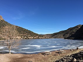 Eagle Valley Reservoir in Spring Valley State Park | |
 Location in Nevada | |
| Location | Lincoln County, Nevada, United States |
| Nearest town | Ursine, Nevada |
| Coordinates | 38°3′14″N 114°10′14″W / 38.05389°N 114.17056°W[1] |
| Area | 926.83 acres (375.07 ha)[2] |
| Elevation | 5,869 ft (1,789 m)[1] |
| Designation | Nevada state park |
| Established | 1969 |
| Visitors | 29,311 (in 2017)[3] |
| Administrator | Nevada Division of State Parks |
| Website | Spring Valley State Park |
History edit
The Eagle Valley Dam was built in 1965, creating the Eagle Valley Reservoir for agricultural usage. The area around the reservoir was designated a state park in 1969.[5]
Activities and amenities edit
The park offers camping, fishing, a boat launch, picnicking, hiking trails, historic ranch buildings, and a group-use area.
Climate edit
| Climate data for Spring Valley State Park, Nevada, 1991–2020 normals, 1974-2020 extremes: 5950ft (1814m) | |||||||||||||
|---|---|---|---|---|---|---|---|---|---|---|---|---|---|
| Month | Jan | Feb | Mar | Apr | May | Jun | Jul | Aug | Sep | Oct | Nov | Dec | Year |
| Record high °F (°C) | 68 (20) |
74 (23) |
80 (27) |
84 (29) |
94 (34) |
99 (37) |
108 (42) |
103 (39) |
99 (37) |
89 (32) |
77 (25) |
68 (20) |
108 (42) |
| Mean maximum °F (°C) | 55.9 (13.3) |
59.5 (15.3) |
67.9 (19.9) |
75.8 (24.3) |
83.8 (28.8) |
92.2 (33.4) |
97.1 (36.2) |
94.0 (34.4) |
88.7 (31.5) |
79.3 (26.3) |
68.1 (20.1) |
57.0 (13.9) |
97.7 (36.5) |
| Mean daily maximum °F (°C) | 43.7 (6.5) |
47.0 (8.3) |
54.7 (12.6) |
62.1 (16.7) |
71.5 (21.9) |
82.9 (28.3) |
89.3 (31.8) |
87.0 (30.6) |
79.8 (26.6) |
66.9 (19.4) |
53.7 (12.1) |
43.6 (6.4) |
65.2 (18.4) |
| Daily mean °F (°C) | 26.9 (−2.8) |
30.9 (−0.6) |
37.9 (3.3) |
43.1 (6.2) |
51.1 (10.6) |
59.1 (15.1) |
66.2 (19.0) |
64.1 (17.8) |
56.3 (13.5) |
44.8 (7.1) |
34.7 (1.5) |
26.3 (−3.2) |
45.1 (7.3) |
| Mean daily minimum °F (°C) | 10.1 (−12.2) |
14.8 (−9.6) |
21.0 (−6.1) |
24.2 (−4.3) |
30.6 (−0.8) |
35.2 (1.8) |
43.2 (6.2) |
41.2 (5.1) |
32.8 (0.4) |
22.8 (−5.1) |
15.8 (−9.0) |
9.0 (−12.8) |
25.1 (−3.9) |
| Mean minimum °F (°C) | −10.9 (−23.8) |
−3.1 (−19.5) |
7.2 (−13.8) |
11.8 (−11.2) |
18.8 (−7.3) |
25.4 (−3.7) |
31.7 (−0.2) |
30.4 (−0.9) |
22.2 (−5.4) |
11.5 (−11.4) |
0.8 (−17.3) |
−8.6 (−22.6) |
−17.4 (−27.4) |
| Record low °F (°C) | −29 (−34) |
−33 (−36) |
−10 (−23) |
−3 (−19) |
9 (−13) |
13 (−11) |
24 (−4) |
21 (−6) |
13 (−11) |
−2 (−19) |
−26 (−32) |
−45 (−43) |
−45 (−43) |
| Average precipitation inches (mm) | 1.04 (26) |
1.51 (38) |
1.42 (36) |
0.87 (22) |
0.86 (22) |
0.51 (13) |
1.00 (25) |
1.57 (40) |
1.00 (25) |
1.22 (31) |
0.69 (18) |
1.43 (36) |
13.12 (332) |
| Average snowfall inches (cm) | 4.80 (12.2) |
5.90 (15.0) |
5.00 (12.7) |
1.60 (4.1) |
0.20 (0.51) |
0.00 (0.00) |
0.00 (0.00) |
0.00 (0.00) |
0.00 (0.00) |
0.40 (1.0) |
2.60 (6.6) |
6.10 (15.5) |
26.6 (67.61) |
| Source 1: NOAA (1981-2010 snowfall)[6][7] | |||||||||||||
| Source 2: XMACIS2 (records & monthly max/mins)[8] | |||||||||||||
References edit
- ^ a b "Spring Valley State Park". Geographic Names Information System. United States Geological Survey, United States Department of the Interior.
- ^ "Inventory of State Lands" (PDF). Nevada Division of State Lands. April 27, 2018. Retrieved November 28, 2019.
- ^ "Division of State Parks Performance Audit" (PDF). Nevada Legislature. 2018.
- ^ "Spring Valley State Park". Nevada State Parks. Department of Conservation and Natural Resources. Retrieved January 25, 2017.
- ^ "History of Spring Valley State Park". Nevada State Parks. Department of Conservation and Natural Resources. Retrieved January 25, 2017.
- ^ "Spring Valley State Park, Nevada 1991-2020 Monthly Normals". Retrieved November 14, 2023.
- ^ "Spring Valley State Park, Nevada 1981-2010 Monthly Normals". Retrieved November 14, 2023.
- ^ "xmACIS". National Oceanic and Atmospheric Administration. Retrieved November 14, 2023.
External links edit
Wikimedia Commons has media related to Spring Valley State Park.
- Spring Valley State Park Nevada State Parks