


Summary
St Helen's Square is an open space in the city centre of York, England.
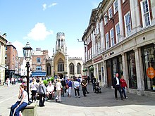
 St Helen's Square, looking south-west | |
 Location within York | |
| Maintained by | City of York |
|---|---|
| Location | York, England, UK |
| Coordinates | 53°57′37″N 1°05′04″W / 53.96015°N 1.08448°W |
| North | |
| East | Davygate |
| South | Coney Street |
| West | Lendal |
| Construction | |
| Completion | 1745 |
History edit
During the Roman era, Eboracum's south-western gate, the porta praetoria, lay where the square is now.[1]
Until the mid-18th century much of the space was occupied by the graveyard of St Helen's, Stonegate. The streets of Stonegate and Davygate ran either side of the graveyard, meeting Coney Street at a junction known as Cuckold's Corner. In addition a footpath ran across the graveyard, linking Davygate with the junction of Stonegate and Blake Street.[2]
In 1745 St Helen's was given a plot of land on Davygate for use as a new graveyard and the old graveyard was paved over to form St Helen's Square. In the early 20th century the square was enlarged to the south-east, giving it a more regular, rectangular, shape.[2]
The York Tavern, built on the square in 1770, became one of two main departure points for stagecoaches to London.[3][4] By 1818 Terry's had set up its shop on the square and it remained there, later also operating as a restaurant, until 1980.[5][6]
In winter the square is now the location of a large Christmas tree and the city's Christmas lights are turned on in a ceremony held in the square.[7][8] The square is also a popular location for demonstrations and rallies.[9][10] 0
Layout and architecture edit
The square is an important junction, with Coney Street leading from its southern corner, Lendal from the west, both Blake Street and Stonegate from the north and Davygate from the east.[2]
The south-western side of the square is occupied by the Mansion House and there is also access to the York Guildhall, which can be seen through a gateway. On the north-western side Harkers was constructed for the Yorkshire Insurance Company, and the York County Savings Bank Building was also built in the mid-19th century for a local institution. Both are listed, as is the former Terry's building at 3 St Helen's Square. The 18th-century Number 7, on the north-eastern side, is also listed, with the remainder of this side occupied by St Helen's Church. Numbers 2-8, occupying the south-eastern side, were built in 1929 and are also listed. Part of the building is occupied by Bettys tea rooms.[2][11]
References edit
- ^ "Roman Fortress". York Civic Trust. Retrieved 10 August 2020.
- ^ a b c d An Inventory of the Historical Monuments in City of York, Volume 5, Central. London: HMSO. 1981. Retrieved 7 August 2020.
- ^ A History of the County of York: the City of York. London: Victoria County History. 1961. Retrieved 7 August 2020.
- ^ Combe, William (1785). The history and antiquities of the city of York, from its origin to the present times. Vol. 2. p. 379. Retrieved 11 August 2020.
- ^ Pigot, James (1818). The Commercial Directory for 1818-19-20. Manchester: J Pigot & co. p. 487. Retrieved 24 March 2017.
- ^ Historic England. "3, ST HELENS SQUARE (Grade II) (1256797)". National Heritage List for England. Retrieved 26 March 2017.
- ^ "Lockdown! This is what St Helen's Square looks like now". York Mix. 13 November 2019. Retrieved 10 August 2020.
- ^ Walton, Simon (15 October 2019). "When will York's Christmas lights 2019 be switched on?". The Press. Retrieved 10 August 2020.
- ^ "'People's Parliament' rally to be held in York". York Mix. 29 August 2019. Retrieved 10 August 2020.
- ^ Dodd, George (20 September 2019). "Hundreds take to St Helen's Square to protest over climate change". The Press. Retrieved 10 August 2020.
- ^ "Character Area Eleven: Central Shopping Area". City of York Council. Retrieved 10 August 2020.
External links edit
![]() Media related to St Helen's Square, York at Wikimedia Commons
Media related to St Helen's Square, York at Wikimedia Commons