


Summary
Stabroek was the old name of Georgetown, Guyana, between 1784 and 1812, and was the capital of Demerara. Stabroek is currently a ward in the centre of Georgetown.
Stabroek | |
|---|---|
 Stabroek | |
| Coordinates: 6°48′25″N 58°09′36″W / 6.8070406°N 58.1599689°W | |
| Country | Guyana |
| City | Georgetown |
| Established | 1782 |
| Area | |
| • Total | 0.6 km2 (0.25 sq mi) |
History edit
In 1748, Governor Laurens Storm van 's Gravesande build a guard post at the mouth of the Demerara River. Later English planters started to build houses around the guard post creating a little village.[1] The town was established in 1782 during a brief occupation by the French of the Dutch colony of Demerara. The original name of Longchamps was changed to Stabroek in 1784, after Nicholaas Geelvinck (1732 — 1787), Lord of Stabroek, the then President of the Dutch West India Company.[2]
| Year | Pop. |
|---|---|
| 1789 | 780[3] |
| 1807 | 8,500[3] |
| 2012 | 251[4] |
In 1789, the population was 780 people of which 239 were whites,[3] however the town rapidly started to grow and by 1807 had a population of around 8,500 people.[3] American traders started to build a wharf which became known as American Stelling, and little towns started to appear around the main settlement.[5]
The city's name changed again in 1812 when, under British rule, it became Georgetown.[3] A ward of the city, one fourth of a mile broad and one mile long, retains the name Stabroek.[6]
Brickdam, Stabroek's main street, was paved with bricks and made of burnt earth until 1921 when it was paved over for the arrival of the Prince of Wales.[6] The upper side of Brickdam was once lined with palm trees.[6]
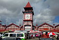
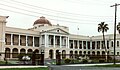
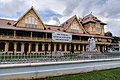
The old name of the city is still reflected in Georgetown's main market, Stabroek Market, which has existed on or near its present location since the 18th century,[7] and the newspaper Stabroek News, established in 1986.[8] The Parliament Building is located in Stabroek on the same spot where the Court of Policy used to be.[6]
Gallery edit
-
-
-

-
 Supreme Court
 -
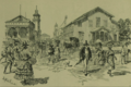 Stabroek in 1888


References edit
- ^ "Establishment of Demerara". Guyana Times International. Retrieved 11 August 2020.
- ^ Smith, Raymond T. (1956). "CHAPTER II HISTORY: EARLY SETTLEMENT AND THE PERIOD OF DUTCH CONTROL". London: Routledge & Kegan Paul Limited. ISBN 0415863295. Archived from the original on 4 March 2016. Retrieved 2021-04-08.
- ^ a b c d e Netscher 1888, p. 301.
- ^ "2012 Population by Village". Statistics Guyana. Retrieved 15 August 2020.
- ^ "36. GROWTH OF GEORGETOWN". Retrieved 12 August 2020.
- ^ a b c d "The development of Stabroek". National Trust of Guyana. Retrieved 11 August 2020.
- ^ Lloyd Kandasammy, Celebrating Guyana's built heritage: Stabroek Market, a brief history in Stabroek News, April 14, 2005
- ^ Andrew Graham-Yooll, The newspaper Stabroek News, Round Table, Oct 94 Issue 332, p447
Bibliography edit
- Netscher, Pieter Marinus (1888). Geschiedenis van de koloniën Essequebo, Demerary en Berbice, van de vestiging der Nederlanders aldaar tot op onzen tijd (in Dutch). The Hague: Martinus Nijhoff.
External links edit
- Aerial view
- The Growth of Georgetown