
KNOWPIA
WELCOME TO KNOWPIA

Stac Levenish 
Summary
Stac Levenish or Stac Leibhinis (sometimes simply called Levenish/Leibhinis) is a sea stack in the St Kilda archipelago in Scotland. Lying 2.5 kilometres (1+1⁄4 nautical miles) off Village Bay on Hirta, it is part of the rim of an extinct volcano that includes Dùn, Ruaival and Mullach Sgar.[2]
| Scottish Gaelic name | Stac Leibhinis |
|---|---|
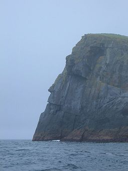 Stac Levenish cliff's face silhouette | |
| Location | |
 Stac Levenish Stac Levenish shown within the Outer Hebrides | |
| OS grid reference | NF133966 |
| Coordinates | 57°47′31″N 8°30′36″W / 57.792°N 8.510°W |
| Physical geography | |
| Island group | St Kilda |
| Area | 24,280 m2 (261,350 sq ft) |
| Highest elevation | 62 m (203 ft) |
| Administration | |
| Sovereign state | United Kingdom |
| Country | Scotland |
| Council area | Outer Hebrides |
| References | [1][2][3] |

The stack is 62 metres (203 ft) high. Its north cliff appears to have the profile of a human face, visible when travelling to St Kilda from the east. The skerry of Na Bodhan lies to the north east.

The stack was climbed recreationally in the early 1900s; Norman Heathcote mentions a moderately difficult ascent in 1900, as part of a climbing expedition that also included an ascent of Stac Lee.[4]
See also edit
References edit
- ^ National Records of Scotland (15 August 2013). "Appendix 2: Population and households on Scotland's Inhabited Islands" (PDF). Statistical Bulletin: 2011 Census: First Results on Population and Household Estimates for Scotland Release 1C (Part Two) (PDF) (Report). SG/2013/126. Retrieved 14 August 2020.
- ^ a b Haswell-Smith, Hamish (2004). The Scottish Islands. Edinburgh: Canongate. ISBN 978-1-84195-454-7.
- ^ Ordnance Survey: Landranger map sheet 18 Sound of Harris (North Uist, Taransay & St Kilda) (Map). Ordnance Survey. 2008. ISBN 9780319231272.
- ^ Heathcote, Norman (1901). "Climbing in St Kilda". Scottish Mountaineering Club Journal. 6. Scottish Mountaineering Club: 146–151. Retrieved 8 February 2009.
External links edit
- Pictures
- Painting of the Stac
57°47′32″N 8°30′37″W / 57.79222°N 8.51028°W