


Summary
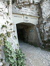
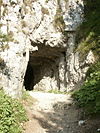
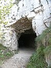
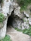
The Strada delle 52 Gallerie ("Road of 52 tunnels"), also known as the 52 Tunnel Road, or Strada della Prima Armata ("Road of the First Army") is a military mule road built during World War I on the Pasubio massif in Veneto, Italy.
| Road of 52 Tunnels, Road of the first Army | |
|---|---|
Strada delle 52 gallerie, Strada della Prima Armata | |
 Road of 52 Tunnels | |
 Road of 52 Tunnels, Road of the first Army | |
| Coordinates | 45°46′44″N 11°13′41″E / 45.779°N 11.228°E |
| Type | military mule |
| Site information | |
| Controlled by | Kingdom of Italy |
| Open to the public | yes |
| Site history | |
| Built | February 6, 1917 |
| Built by | Kingdom of Italy |
| In use | Kingdom of Italy |
| Battles/wars | World War I |
| Strada delle 52 Gallerie | |
|---|---|
| Length | 6.5 km (4.0 mi) |
| Trailheads |
|
| Use | Hiking |
| Elevation change | 750 m (2,460 ft) |
| Highest point | the end of 47th tunnel, 2,000 m (6,600 ft) |
| Lowest point | Bocchetta Campiglia, 1,216 m (3,990 ft) |
| Grade | 22 % |
| Season | summer |
| Surface | rock |
| Right of way | military mule |
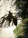
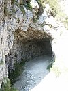
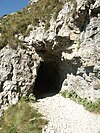
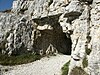
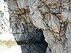
The road winds between Bocchetta Campiglia (1,216 metres [3,990 ft]) [1] and the Porte del Pasubio (1,934 metres [6,345 ft]) [2] crossing the southern slope of the mountain with its spires, deep canyons and sheer rock faces, outside of the range of Austro-Hungarian artillery.
Features edit
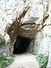
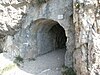
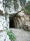
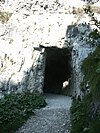
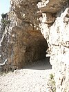
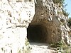
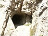
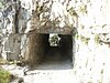
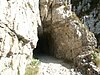
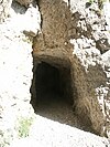
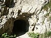
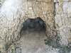
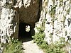
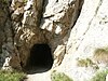
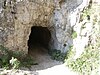
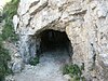
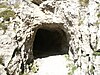
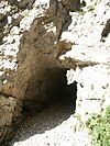
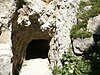
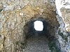
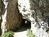
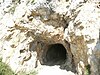
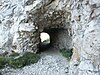
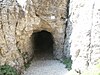
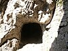
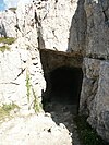
It is 6,555 metres (21,506 ft) long, of which 2,335 metres (7,661 ft)[3] are divided into 52 tunnels excavated from the rock, each tunnel is numbered and characterized by a particular name. The minimum width of 2.20 metres (7.2 ft) was originally intended to allow the transit of two mules with their baggage. [4] The slope of the road reaches 22 percent, with an average of 12 percent.[4] Notable among the many tunnels is the 19th because, in addition to being the longest (320 metres (1,050 ft)), it has a helical layout with 4 hairpin bends, inside a gigantic rock tower.[5]
The Tunnel 20 is carved out of a rock tower, and to overcome the difference in height, twists around itself like a corkscrew. Tunnels 41 through 45 run below the Passo Fontana d'oro (1,875 metres [6,152 ft]). On leaving the 47th, the highest point of the road (2,000 metres [6,562 ft]), there is a magnificent panorama.[peacock prose]


Completion edit
A masterpiece of military engineering and boldness (it was produced by the 33rd Miners Company of the Italian Army with the help of six hundred workers), considering the conditions and the time it was built, and the speed of execution. Work began on February 6, 1917, and was completed in November 1917.
Its implementation was of great strategic importance because it allowed communication and transfer of supplies from the base to the summit area of Mt. Pasubio. Key aspects of the road include year round access, located outside of enemy artillery range and accessible by mule. These were all problems with the similar road of Scarubbi which is only accessible with motorized vehicles, within the range of the Austro-Hungarian guns, and only during the summer.
Mountain biking is strictly prohibited due to a number of fatal accidents.
|
|


References edit
Notes edit
- ^ a b (Gattera 2007, p. 27).
- ^ a b (Gattera 2007, p. 38).
- ^ (Gattera 2007, p. 100-109)length of the galleries is obtained by adding the lengths of the individual galleries mentioned in the book
- ^ a b (Gattera 2007, p. 78) taken from the technical report of Captain Corrado Picone.
- ^ (Gattera 2007, p. 30).
Cartography edit
- (in Italian) "Sentieri Pasubio e Carega-foglio Nord" 1:20.000 Sezioni vicentine del CAI
- (in Italian) Sentieri della val di Posina, edito dalla Provincia di Vicenza, assessorato al turismo 26 April 2013
- Kompass – carte, ed. (2003). Carta turistica 1:50000 n.101 – Rovereto M.Pasubio (in Italian). ISBN 9783854911036.
Bibliography edit
- Claudio Gattera (2007). Gino Rossato Editore (ed.). Il pasubio e la strada delle 52 gallerie (in Italian). ISBN 978-88-8130-017-4.
External links edit
- (in Italian) Strada delle 52 gallerie
- (in Italian) Strada delle 52 gallerie Itinerario
- (in German) Bericht über die Strada delle 52 Galerie im Explorermagazin