


Summary
Stratford is a rural locality in the Mid-Coast Council local government area in the Hunter Region of New South Wales, Australia.[1][7] The largest population centre in the area is the town of Stratford, which is approximately 14 kilometres (9 mi) south of Gloucester and 109 km (68 mi) north of Newcastle. Stratford, which is next to the Avon River, is on Bucketts Way, 66 km (41 mi) from the Pacific Highway, the nearest major highway.
| Stratford New South Wales | |
|---|---|
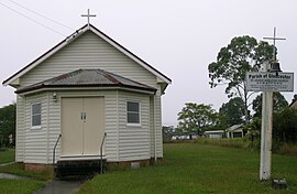 St John's Anglican Church, Stratford, NSW. | |
 Stratford | |
| Coordinates | 32°6′54″S 151°56′4″E / 32.11500°S 151.93444°E |
| Population | 110 (township) (2006)[2]Note1 |
| Postcode(s) | 2422 |
| Elevation | 130 m (427 ft)[3] |
| Time zone | AEST (UTC+10) |
| • Summer (DST) | AEDT (UTC+11) |
| Location |
|
| LGA(s) | Mid-Coast Council[1] |
| Region | Mid North Coast[1] |
| County | Gloucester[4] |
| Parish | Avon[4] |
| State electorate(s) | Upper Hunter[5] |
| Federal division(s) | Lyne[6] |
At the 2006 census, the village of Stratford had a population of 110.[2] The village has a park with cricket pitch and play-gym, a New South Wales Rural Fire Service shed, shop with petroleum, hall, church, public school and the Stratford lawn cemetery. The village is located on one of the main access routes to the Barrington Tops National Park.
The principal industries of the area include mining, beef cattle breeding and dairying. The nearby Stratford coal mine transports coal to Newcastle for export or the New South Wales Power Stations.[8]
Notes edit
- ^ This population figure is for the village only. The Australian Bureau of Statistics data for Stratford does not include the entire suburb.
References edit
- ^ a b c "Suburb Search - Local Council Boundaries - Hunter (HT) - Gloucester Shire Council". New South Wales Division of Local Government. Retrieved 8 March 2009.
- ^ a b Australian Bureau of Statistics (25 October 2007). "Stratford (State Suburb)". 2006 Census QuickStats. Retrieved 8 March 2009. Map
- ^ Topographic map 8233 Dungog
- ^ a b "Stratford". Geographical Names Register (GNR) of NSW. Geographical Names Board of New South Wales. Retrieved 8 March 2009.
- ^ "Upper Hunter". New South Wales Electoral Commission. Retrieved 23 November 2019.
- ^ "Lyne". Australian Electoral Commission. 22 December 2009. Retrieved 29 July 2010.
- ^ "Stratford". Land and Property Management Authority - Spatial Information eXchange. New South Wales Land and Property Information. Retrieved 8 March 2009.
- ^ "Proposed Roseville West Pit – Stratford Coal Mine" (PDF). Assessment Report. NSW Government. Retrieved 23 May 2011.