
KNOWPIA
WELCOME TO KNOWPIA

Styrian Prealps 
Summary
The Styrian Prealps (in German Steirisches Randgebirge, in Slovenian Štajersko Robno hribovje, in Hungarian Stájer Elő-Alpok) is the proposed name for a subdivision of mountains in a new, and as yet unadopted, classification of the Alps, located in Austria and, marginally, in Slovenia and Hungary.
| Styrian Prealps | |
|---|---|
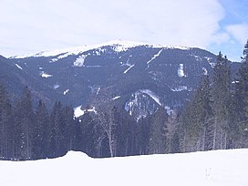 The Stuhleck (1,782 m) in winter | |
| Highest point | |
| Peak | Ameringkogel |
| Elevation | 2,184 m (7,165 ft) |
| Coordinates | 47°04′16″N 14°48′30″E / 47.07111°N 14.80833°E |
| Geography | |
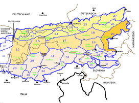 Styrian Prealps (section nr.20) within Eastern Alps
| |
| Countries | Austria, Slovenia and Hungary |
| Settlement | Graz, Maribor |
| Parent range | Alps |
| Borders on | Northern Styrian Alps, Eastern Tauern Alps, Carinthian-Styrian Alps and Slovenian Prealps |
| Geology | |
| Orogeny | Alpine orogeny |
Geography edit
The whole range is drained by the tributaries of the Danube river.
SOIUSA classification edit
According to SOIUSA (International Standardized Mountain Subdivision of the Alps) the Styrian Prealps are an Alpine section, classified in the following way:[1]
- main part = Eastern Alps
- major sector = Central Eastern Alps
- section = Styrian Prealps
- code = II/A-20
Subdivision edit
The Styrian Prealps are divided into four subsections:
- North-western Styrian Prealps (Stubalpe; Gleinalpe; Western Graz Highlands) - SOIUSA code:II/A-20.I;
- South-western Styrian Prealps (Koralpe; Reinischkögel; Kobansko) - SOIUSA code:II/A-20.II
- Central Styrian Prealps (Fischbach Alps; Eastern Graz Highlands) - SOIUSA code:II/A-20.III;
- Eastern Styrian Prealps (Wechsel-Joglland; Bucklige Welt; Bernstein-Güns; Rosalien-Ödenburg) - SOIUSA code:II/A-20.IV.
Notable summits edit

Some notable summits of the Styrian Prealps are:
| Name | metres | feet |
|---|---|---|
| Ameringkogel | 2,184 | 7,164 |
| Großer Speikkogel | 2,140 | 7,019 |
| Stuhleck | 1,782 | 5,845 |
| Wechsel | 1,743 | 5,717 |
| Hochlantsch | 1,720 | 5,642 |
| Košenjak | 1,522 | 4,992 |