


Summary
Sungai Tujoh (Abbrev: Sg. Tujoh), is the westernmost point of Brunei. It is located in the Belait district.[1]
Sungai Tujoh | |
|---|---|
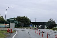
 Sungai Tujoh checkpoint in 2023. | |
 Location in Brunei | |
| Coordinates: 4°35′0″N 114°04′0″E / 4.58333°N 114.06667°E | |
| Country | Brunei |
| District | Belait |
| Mukim | Kuala Belait |
| Government | |
| • Body | Kuala Belait and Seria Municipal Board |
| Population | |
| • Total | 0 |
Sungai Tujoh is a Bruneian territory lies along the Malaysian-Bruneian border. Each country constructed their own immigration complex within their respective territories. The Malaysian side constructed Immigration, Customs, Quarantine and Security (ICQS) Complex at Kuala Baram near the border[2] while Bruneian authorities set up a custom, excise and immigration post staffed by immigration officers.[3] Royal Brunei Police Force (RBPF) control post is also set up to monitor the Brunei-Malaysia border.[4]
Etymology edit
The name of the area is derived from two Bruneian Malay words - Sungai,[5] which means river or stream, and Tujoh[6] or the number seven. Literally, Sungai Tujoh is translated as the Seventh River or Seventh Stream in English.
Although it is sometimes referred to as Kampong Sungai Tujoh, there is no permanent settlement in the area.[citation needed]
Location edit
Sungai Tujoh is located at the westernmost point in Brunei, in the Belait district,[1] It borders with Kuala Baram, Miri District, Sarawak.[7][8] The area is bounded by the border with Malaysia on the west and south side, the South China Sea to the north and the Sungai Enam area to the east.
It is one of the four land crossing points from Brunei to Sarawak and the only one in the Belait district. The other 3 are Kuala Lurah in the Brunei-Muara district to Limbang and the Puni and Labu Immigration post in the Temburong district to Limbang and Terusan respectively.[3]
History edit
The Sungai Tujoh area has been long claimed by the sultan of Brunei to constitute a part of the sultanate. It was divided in 1882, when the then sultan ceded the basin of the Baram to the White Rajah of Sarawak, an area of some 10,000 square miles (30,000 km2), on condition of a perpetual annual payment of 6000 dollars.[9]
The border was delineated in 1958 by the United Kingdom[10] who then had sovereignty over the colony of Sarawak and was responsible for the external relations of the protectorate of Brunei. An immigration post was built in the 1960s to control the movement of goods and people between Miri and points west in Sarawak with Brunei.[citation needed] In 2003, ASEAN Bridge was constructed across the Baram River, connecting the city of Miri to Malaysian ICQS complex in Sungai Tujoh. Initially, it was a toll bridge. The bridge become toll-free in 2015.[11]
The frequent traveller's card (FTC) was first implemented in 2005 at Sungai Tujoh. This enables residents from both countries to use their Mykad/Smart IC as a legal document for travel between the two countries instead of an international passport. As at December 2013 the FTC is no longer accepted. [12]
Transport edit
The main roads linking the ferry crossing towards the Malaysian border (11 kilometers)[13] and towards Rasau bridge are surfaced.
There is a scheduled bus service that runs from Kuala Belait and terminates at the immigration post at Sungai Tujoh.[14] Passengers have to clear customs and immigration on foot and take a separate bus to Miri.
Gallery edit
-
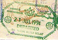 Brunei exit stamp from the Sg Tujoh border crossing
 -
 Malaysian entry stamp from its checkpoint.
 -
 Border checkpoint of Brunei
 -
 Border checkpoint of Malaysia
 -
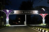 Farewell sign from Sarawak


Notes edit
- ^ a b Poskod Baru Daerah Belait Archived 2 April 2008 at the Wayback Machine - Retrieved 22 May 2007
- ^ "Sarawak minister: Sungai Tujuh ICQS to be upgraded, traffic flow to improve". The Malay Mail. 23 December 2022. Archived from the original on 23 December 2022. Retrieved 26 December 2022.
- ^ a b Brunei Immigration Department Beef Up At All Control Posts, Brudirect 24 November 2003- retrieved 22-05-2007 Archived 28 September 2007 at the Wayback Machine
- ^ Belait Under Royal Scrutiny, Brudirect 3 April 2005 - retrieved 22-05-2007 Archived 28 September 2007 at the Wayback Machine
- ^ Websters Dictionary Online Archived 27 September 2007 at the Wayback Machine
- ^ This is usually spelt as Tujuh in standard Malay. Websters Dictionary Online Archived 30 September 2007 at the Wayback Machine
- ^ "Welcome arch at Sg Tujuh checkpoint costing RM 390,300 officially opened". Dayak Daily. 7 July 2022. Archived from the original on 15 August 2022. Retrieved 26 December 2022.
- ^ "Malaysian royal customs department, Sarawak branch". Archived from the original on 8 August 2022. Retrieved 26 December 2022.
- ^ The Pagan Tribes of Borneo, retrieved 22-05-2007 Archived 28 September 2007 at the Wayback Machine
- ^ Brunei's Overlapping Maritime Claim with Malaysia over the Spratleys - retrieved 22-05-2007 Archived 28 June 2007 at the Wayback Machine
- ^ Yu, Ji (17 May 2015). "Asean Bridge in Miri to be free from June". The Star. Archived from the original on 2 December 2016. Retrieved 24 July 2023.
- ^ Ministry of Foreign Affairs Announcement, dated 25 September 2006, retrieved 22-05-2007 Archived 27 September 2007 at the Wayback Machine
- ^ National Development Plan Archived 5 April 2007 at the Wayback Machine of Brunei Darussalam. Government site Retrieved 19 April 2007.
- ^ Biaramas fares from Sarawak Archived 9 April 2007 at the Wayback Machine - Retrieved 19 April 2007