


Summary
Surat /səˈræt/ is a rural town and locality in the Maranoa Region, Queensland, Australia.[4][5] In the 2021 census, the locality of Surat had a population of 402 people.[6]
| Surat Queensland | |||||||||||||||
|---|---|---|---|---|---|---|---|---|---|---|---|---|---|---|---|
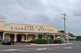 Cobb and Co Changing Station | |||||||||||||||
 Surat | |||||||||||||||
| Coordinates | 27°09′16″S 149°04′04″E / 27.1544°S 149.0677°E | ||||||||||||||
| Population | 402 (SAL 2021)[1][2] | ||||||||||||||
| Established | 1849 | ||||||||||||||
| Postcode(s) | 4417 | ||||||||||||||
| Elevation | 246 m (807 ft)[3] | ||||||||||||||
| Area | 2.1 km2 (0.8 sq mi) | ||||||||||||||
| Time zone | AEST (UTC+10:00) | ||||||||||||||
| Location | |||||||||||||||
| LGA(s) | Maranoa Region | ||||||||||||||
| State electorate(s) | Warrego | ||||||||||||||
| Federal division(s) | Maranoa | ||||||||||||||
| |||||||||||||||
| |||||||||||||||
Geography edit

The town of Surat is on the Balonne River, approximately 75 kilometres (47 mi) south of Roma on the Carnarvon Highway in South West Queensland. It is 450 kilometres (280 mi) west of Brisbane.
There are oil fields further south.
History edit
Mandandanji edit
Mandandanji (also known as Mandandanyi, Mandandanjdji, Kogai) is an Australian Aboriginal language spoken by the Mandandanji people. The Mandandanji language region includes the landscape within the local government boundaries of the Maranoa Regional Council, particularly Roma, Yuleba and Surat, then east towards Chinchilla and south-west towards Mitchell and St George.[7]
British colonisation edit
The first documented British exploration of the area was the expedition led by New South Wales Surveyor-General Sir Thomas Mitchell in 1846.[8][page needed]
Pastoralist squatters soon followed in 1848 with Joseph Fleming establishing the Talavera station and Thomas Simpson Hall forming the Surat, Colgoon, Weribone and Yamboucal stations along the upper Balonne River. Hall and Fleming faced considerable resistance from the local Mandandanji to their occupation of the land, and had to maintain a force of twelve armed men against the "native blacks". Fleming, who was the brother of John Henry Fleming, the main instigator of the Myall Creek massacre, named his property Talavera (a famous battle of the Peninsular War) due to his battles with the Aborigines there. It is unknown why Hall called one of his properties Surat but it was possibly named after the city of Surat in India.[9][8][page needed]
The local Commissioner of Crown Lands, John Henry Durbin, established a hut at Yamboucal in 1849 and within a month, he was under siege from the Mandandanji. Some reports indicate that to break the siege, Durbin and his troopers shot a large number of Aborigines. Roderick Mitchell, the son of Sir Thomas Mitchell, took over as Commissioner of Crown Lands and in 1850 moved the residence around two kilometres upstream from Durbin's hut. The new settlement was called Surat. The Mandandanji again resisted, killing Mitchell's bullocks and preventing his men from building the huts. Mitchell dispersed the local Aborigines in a show of force, allowing the first of Surat's houses to be built. In 1851, government surveyor Robert Cooper Bagot mapped the township of Surat.[8][page needed][10]
Due to patrols of the Native Police, local Aboriginal resistance had ceased by 1852. Thomas Davis, the father of Steele Rudd the writer, lived in Surat in the early 1850s and recalled the fearful and unjustified slaughter of Aboriginal people resulting from these patrols, even though he actively participated in some of them.[11] One of the last mass-killings in the vicinity occurred a kilometre downstream from Surat in May 1852, where a massacre of peaceful Aboriginal workers on Hall's Yamboucal station was perpetrated by Native Police troopers led by local colonists.[8]
Surat as a town was slow to develop, still only having three buildings by the early 1860s. The 1870s saw some civic infrastructure evolve.[10]
Schools and churches edit

Surat State School opened on 23 July 1874.[12]
All Saints Anglican Church was built from timber by contractor Mr Williams and opened on Sunday 23 February 1879.[13][14][15] It was replaced in 1938 by another timber church, St John the Divine Anglican Church, which was opened by Archbishop William Wand on Sunday 24 April 1938.[16] St John's was designed by architect Lange Powell. It was closed in 2019. Both Anglican churches were at 27 Cordelia Street (27°09′16″S 149°04′04″E / 27.154498°S 149.0677°E).[17][18]
St Peter and St Paul's Catholic Church was built from timber in 1884. It was in Robert Street. In 1956, it was replaced by the new Church of the Immaculate Conception in Ivan Steet. In 1965, it was replaced by a new brick church also called the Church of the Immaculate Conception, designed by Ian Ferrier.[19][20][21]
St Stephen's Presbyterian Church was built from timber by Mr R.T. Garvie. It was opened on Wednesday 31 October 1934.[22] It was at 33 William Street (27°09′09″S 149°03′53″E / 27.15257°S 149.0647°E). It has closed and is now used as Surat's Men's Shed.[23]
The Kingdom Hall of Jehovah's Witnesses opened about 1985.[24]
At the 2011 census, the locality had a population of 426.[25]
In the 2016 census, the locality of Surat had a population of 407 people.[26]
In the 2021 census, the locality of Surat had a population of 402 people.[6]
Heritage listings edit

Surat has a number of heritage-listed sites, including:
- 77 Burrowes Street: Astor Theatre[27]
- corner Cordelia & William Streets: Warroo Shire Hall[28]
Education edit

Surat State School is a government primary and secondary (Prep-10) school for boys and girls at 55 Robert Street (27°09′15″S 149°04′01″E / 27.1543°S 149.0670°E).[29][30] In 2017, the school had an enrolment of 87 students with 14 teachers (12 full-time equivalent) and 10 non-teaching staff (8 full-time equivalent).[31] In 2018, the school had an enrolment of 97 students with 13 teachers (12 full-time equivalent) and 11 non-teaching staff (8 full-time equivalent).[32]
There are no secondary schooling to Year 12 in Surat nor nearby. Options are distance education or boarding school.[33]
Amenities edit
Maranoa Regional Council operates a public library at 62 Burrowes Street, within the Cobb & Co. Changing Station complex.[34] The public library opened in 1997 and has publicly accessible Wi-Fi.[35] The complex also has a Cobb & Co changing station, freshwater aquarium, social history museum, theatre and shire hall and the Balonne gallery.[36][37]
The Roman Catholic Church of the Immaculate Conception is aat 99 Ivan Street (27°09′26″S 149°04′22″E / 27.157085°S 149.0728°E).[21]
Media edit
Along with a number of other regional Australian newspapers owned by NewsCorp, the Surat Basin News newspaper ceased publication in June 2020.[38]
Attractions edit

Surat's war memorial is sited on the banks of the Maranoa River, immediately alongside the town's water scheme which was dedicated to the local citizens who lost their lives in military service during the Second World War.[39][40]
References edit
- ^ Australian Bureau of Statistics (28 June 2022). "Surat (suburb and locality)". Australian Census 2021 QuickStats. Retrieved 28 June 2022.
- ^ Australian Bureau of Statistics (28 June 2022). "Surat (suburb and locality)". Australian Census 2021.
- ^ "SURAT". Climate Averages for Australian Sites. Bureau of Meteorology. Archived from the original on 4 December 2009. Retrieved 30 January 2010.
- ^ "Surat – town in Maranoa Region (entry 32870)". Queensland Place Names. Queensland Government. Retrieved 16 November 2019.
- ^ "Surat – locality in Maranoa Region (entry 47455)". Queensland Place Names. Queensland Government. Retrieved 16 November 2019.
- ^ a b Australian Bureau of Statistics (28 June 2022). "Surat (SAL)". 2021 Census QuickStats. Retrieved 28 February 2023.
- ^ "Mandandanji". State Library of Queensland. 15 January 2020. Archived from the original on 4 December 2020.
- ^ a b c d Collins, Patrick (2002). Goodbye Bussamarai, The Mandandanji Land War, Southern Queensland 1842-1852. St Lucia: UQP. ISBN 0702232939.
- ^ "A2 Series - Reel A2.17" (PDF). State Library of Queensland. State Library of Queensland. Retrieved 9 September 2023.
- ^ a b Taylor, R.B (1956). Early Settlement in Surat-Mount Abundance Area. University of Queensland.
- ^ Davis, Thomas (1902). Recollections of Thomas Davis.
- ^ Queensland Family History Society (2010), Queensland schools past and present (Version 1.01 ed.), Queensland Family History Society, ISBN 978-1-921171-26-0
- ^ "ROMA". Dalby Herald And Western Queensland Advertiser. Vol. IX, no. 504. Queensland, Australia. 29 May 1875. p. 2. Retrieved 3 July 2023 – via National Library of Australia.
- ^ "Surat". The St. George Standard And Balonne Advertiser. Vol. I, no. 34. Queensland, Australia. 26 February 1879. p. 2. Retrieved 3 July 2023 – via National Library of Australia.
- ^ "SURAT". Queensland Times, Ipswich Herald And General Advertiser. Vol. XVIII, no. 2470. Queensland, Australia. 29 October 1878. p. 4. Retrieved 3 July 2023 – via National Library of Australia.
- ^ Blake, Thom. "All Saints Anglican Church". Queensland Religious Places. Retrieved 23 June 2023.
- ^ Blake, Thom. "St John the Divine Anglican Church". Queensland Religious Places. Retrieved 23 June 2023.
- ^ "£900 CHURCH AT SURAT". Sunday Mail. No. 418. Queensland, Australia. 24 April 1938. p. 10. Retrieved 3 July 2023 – via National Library of Australia.
- ^ Blake, Thom. "St Peter and St Paul's Catholic Church". Queensland Religious Places. Retrieved 23 June 2023.
- ^ Blake, Thom. "Church of the Immaculate Conception". Queensland Religious Places. Retrieved 23 June 2023.
- ^ a b Blake, Thom. "Church of the Immaculate Conception". Queensland Religious Places. Retrieved 23 June 2023.
- ^ "NEW PRESBYTERIAN CHURCH AT SURAT". Western Star And Roma Advertiser. No. 4407. Queensland, Australia. 3 November 1934. p. 2. Retrieved 3 July 2023 – via National Library of Australia.
- ^ Blake, Thom. "St Stephen's Presbyterian Church". Queensland Religious Places. Retrieved 23 June 2023.
- ^ Blake, Thom. "Kingdom Hall of Jehovah's Witnesses". Queensland Religious Places. Retrieved 23 June 2023.
- ^ Australian Bureau of Statistics (31 October 2012). "Surat (L) (Urban Centre/Locality)". 2011 Census QuickStats. Retrieved 25 November 2019.
- ^ Australian Bureau of Statistics (27 June 2017). "Surat (SSC)". 2016 Census QuickStats. Retrieved 20 October 2018.
- ^ "Astor Theatre (entry 602352)". Queensland Heritage Register. Queensland Heritage Council. Retrieved 11 July 2013.
- ^ "Warroo Shire Hall (entry 602612)". Queensland Heritage Register. Queensland Heritage Council. Retrieved 11 July 2013.
- ^ "State and non-state school details". Queensland Government. 9 July 2018. Archived from the original on 21 November 2018. Retrieved 21 November 2018.
- ^ "Surat State School". Retrieved 28 September 2023.
- ^ "ACARA School Profile 2017". Archived from the original on 22 November 2018. Retrieved 22 November 2018.
- ^ "ACARA School Profile 2018". Australian Curriculum, Assessment and Reporting Authority. Archived from the original on 27 August 2020. Retrieved 28 January 2020.
- ^ "Queensland Globe". State of Queensland. Retrieved 3 July 2023.
- ^ "Surat Library". Public Libraries Connect. 18 September 2014. Archived from the original on 29 January 2018. Retrieved 29 January 2018.
- ^ "Queensland Public Library Statistical Bulletin 2016-17" (PDF). Public Libraries Connect. November 2017. Archived (PDF) from the original on 30 January 2018. Retrieved 29 January 2018.
- ^ "About the Gallery". Surat on Balonne Gallery. Archived from the original on 29 January 2018. Retrieved 29 January 2018.
- ^ "Cobb & Co Changing Station". Queensland. Archived from the original on 29 January 2018. Retrieved 29 January 2018.
- ^ "Future is digital: News announces major changes". Gatton Star. 28 May 2020. Archived from the original on 22 December 2020. Retrieved 22 December 2020.
- ^ "Surat War Memorial". Queensland War Memorial Register. Archived from the original on 25 March 2023. Retrieved 3 July 2023.
- ^ "Surat Memorial Park Gates". Queensland War Memorial Register. Archived from the original on 25 March 2023. Retrieved 3 July 2023.
External links edit
- "Surat". Queensland Places. Centre for the Government of Queensland, University of Queensland.
- "Town map of Surat". Queensland Government. 1982.