


Summary
18°27′12.2″N 73°13′34.2″E / 18.453389°N 73.226167°E
| Surgad Fort | |
|---|---|
| Raigad district, Maharashtra Near Vaijanath | |
 Fort from village Vaijanath. | |
 Surgad Fort | |
| Coordinates | 18°27′12.2″N 73°13′34.2″E / 18.453389°N 73.226167°E |
| Type | Hill fort |
| Height | 825m This value needs verification. It should be around 280m. Compare Google map terrain data. |
| Site information | |
| Owner | Government of India |
| Open to the public | Yes |
| Condition | Ruins |
| Site history | |
| Materials | Stone |
| Surgad | |
|---|---|
| Difficulty | Easy |
Surgad (Marathi: सुरगड क़िल्ला, .lit “Gods Fort”), is a hill fort located in a spur, fragmented from the Sahyadri ranges of Maharashtra. The fort is situated near Roha, next to the village of Vaijanath in the Raigad district. This fort was an observation fort, which guarded the trade route along the Kundalika river from Sudhagad to Revdanda fort.
History edit
This fort is believed to be built by Shilahar kings and subsequently used by the Nizam of Ahmednagar. The great Maratha king Chhatrapati Shivaji is also believed to have reconstructed this fort. During Rajaram's regime this fort was captured by Shankarji Narayan Sachiv from the Siddi of Janjira. In 1733 again this fort was captured by Senior Bajirao I. During Peshwa period this fort was used to keep prisoners. There is a block of stone with inscriptions in Farsi (Persian) and Devnagari. The inscription records that the fort was built in the beginning of the second year of the command of Sidhi saheb. The architect was Nuryaji and the Governor of the fort was Tukoji Haibat.[1] It seems that the fort was built at times when use of artillery was not known in battle. In the Third Anglo-Maratha War, along with other forts in the neighboring region.this fort was won over by Colonel Prother from the Peshwas in February 1818.
How to reach edit
The nearest railway station is Kolad. The nearest bus stop is at the village Khamb which is on the Mumbai-Goa national highway (NH-17). There is a road from village Khamb to Surgad fort. The distance is about 4 km. It passes through village Vaijanath. The fort is accessible from the Northern side as well as western side. It takes about 1 hour to reach the top of the fort. The path passes through wooded forest. It is suggested[by whom?] to hire a guide from the Surgad during rainy season. There is a small rock patch on the western path. Most of the buildings on the fort are in ruined state. The fort is covered by tall grass during September–November. From atop the fort there are views of the Kundalika river.[2]
Places to visit edit
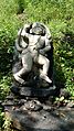
The fort is like a small spur running south from the main hill range. There are 17 rock cut cisterns on the fort. However, the water from the cistern which is on the North-Eastern side is potable. A small temple of the Veer Maruti is also situated atop. The main gate is not in good condition. There is one cannon on the plateau at the base of the fort. There are two good bastions, one at the northern end and the other at the southern end. There are two dilapidated buildings on the fort namely Sadar and daru-kothar. There is a temple of Ansai Devi near the base of the fort.
There is a dense teak and Dhawda forest around the entire fort.
See also edit
Gallery edit
-
 Entrance gate
 -
 Cannon near the fort
 -
 Rock cut cistern
 -
 Temple on the fort
 -
 Surgad western slope
 -
 Rock cut water cisterns on the fort
 -
 Kundalika river from the fort


