


Summary
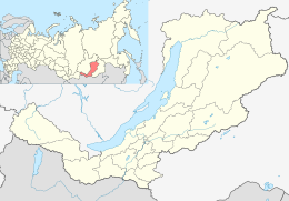
Svyatoy Nos ('Holy Cape') is a large peninsula on the eastern edge of Lake Baikal, Eastern Siberia, in the Barguzinsky District of the Republic of Buryatia. It is part of the Zabaykalsky (Trans-Baikal) National Park.
Святой Нос / Hilmen Hushun | |
|---|---|
 Panorama of the mountains rising above the lakeshore in Svyatoy Nos | |
 Svyatoy Nos | |
| Geography | |
| Coordinates | 53°41′N 108°51′E / 53.69°N 108.85°E |
| Adjacent to | Lake Baikal |
| Length | 56 km (34.8 mi) |
| Width | 20 km (12 mi) |
| Highest elevation | 1,878 m (6161 ft) |
| Highest point | Mount Markova[1] |
| Administration | |
| Federal Subject | Buryatia |
The name "Svyatoy Nos" (Святой Нос) means 'Holy Cape' in Russian. Russian explorers in the 17th and 18th centuries used the word нос nos in the meaning 'cape' (metaphorically based on 'nose'). The name Svyatoy Nos originally referred to the southwestern cape of the peninsula (Мыс Нижнее Изголовье),[2] and a (now abandoned) village on that cape. Then the name passed on the whole territory of the peninsula.[3] In the Buryat language, the peninsula is called Hilmen Hushun, which means "sturgeon's muzzle."[1]
Geography edit

The peninsula consists of two very distinct parts: a large rocky mountainous "island" (Svyatoy Nos proper), and a swampy low-lying land bridge, the Chivyrkuisky Isthmus, that connects it to the mainland.[4][5][6][7][8] Just a few millennia ago, Svyatoy Nos was an island and it was not connected to the mainland.[9] The isthmus was formed by sediments from the Small Chivyrkuy and Barguzin rivers on the mainland, and dust carried by wind,[1][10] dividing the strait between the island and the mainland into two bays, Chivyrkuisky Bay at the northeast and Barguzinsky Bay at the southwest.[11]
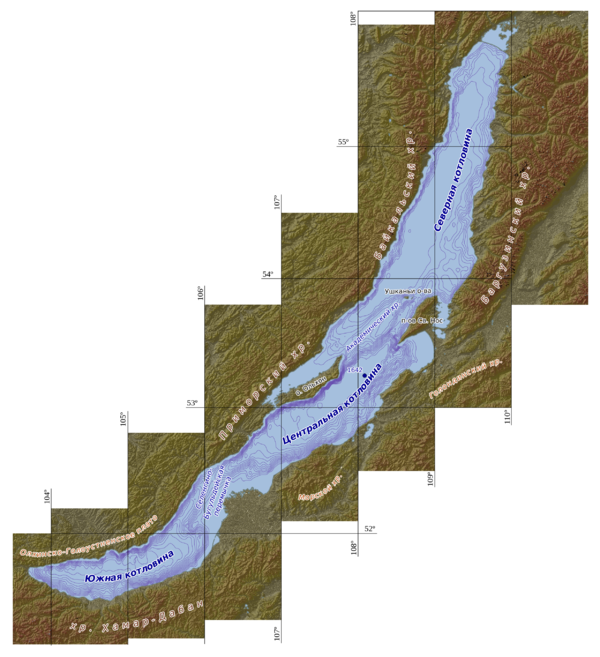
The "island" is spearhead-shaped, 56 km long and 20 km wide, with a sharp tip (at 53°29′41″N 108°31′02″E / 53.49481°N 108.51728°E) pointing southwest and a blunter point at the other end. A mountain ridge runs the whole length of the island; the highest point is the flat peak of Mount Markova[1] (altitude 1878 m, at 53°38′00″N 108°48′27″E / 53.6334°N 108.8075°E), a popular hiking destination with a scenic view of most of Lake Baikal.
The west side of the ridge starts with a low cliff all along the shore and then rises towards the crest in a single general slope, cut by many valleys.[12][4] The eastern side is more irregular, with some flat areas next to the shore in the middle part, and some broad low-lying valleys in the northeast. Snake Bay is a three-pronged 6 km wide branch of Chivyrkuisky Bay that breaks the outline of the island at that point, pushing the shore 4 km to the west.[4][11]
The Svyatoy Nos ridge is roughly parallel to the Academician underwater ridge, which separates Lake Baikal into northern and southern basins and rises above the water level at the Ushkan Islands and the Olkhon Island.[13]

A large number of brooks flow down both sides of the ridge. The largest one, the Krestovskaya River, flows into Snake Bay at 53°44′54″N 109°02′31″E / 53.748370°N 109.04189°E. The Burmuy River runs south-east into Arangatuy Lake on the isthmus.[1][3][11] The sand of the Marokov Beach is said be "singing", because of the sound made by walking on it.[14][15] The peninsula has more than a hundred hydrothermal springs and small mud volcanoes, with various temperatures up to 85 °C. On the isthmus, the springs create many shallow brackish ponds, generally round or oval.[11] The Zmeyevaya sulfurous springs, on the northern end of Snake Bay.
The Big Ushkan Island is located about 10 km northwest of the peninsula. There are seven islands in Chivyrkuisky Bay.[16] The largest and southernmost one is Great Baklany, about 1300 by 160 m, is located about 6 km north of the isthmus, 6 km east of the Svyatoy Nos "island", and 4 km west of the mainland.[4]
Flora and fauna edit
The central part of the island belongs to the zone of high-altitude tundra.[1]
The island is forested with birch, larch, pine, and rhododendrons.[14][15]
Habitation edit
There are three small settlements on the Peninsula, all on the west shore of Chivyrkuisky Bay. The largest is Kurbulik at 53°42′23″N 109°02′27″E / 53.70649°N 109.04083°E, with about a hundred people. The other two settlements, further south, are Katun at 53°40′40″N 109°01′35″E / 53.67772°N 109.02646°E[17] and Monakhovo at 53°40′10″N 109°00′23″E / 53.66958°N 109.00625°E.[18][19]
There is also a place called Glinka near the shore of Barguzinsky Bay, about 1 km southwest of the isthmus (53°35′45″N 108°50′56″E / 53.59576°N 108.84879°E), with some tourist lodging. which is the start of a popular hiking trail to the top of Mount Markov.[20]
The nearest significant town is Ust-Barguzin, located on the mainland shore, at the mouth of the Barguzin River, just south of the isthmus.
There is a road that leads from Ust-Barguzin and follows along the southern shore of the isthmus until the main island. It then splits into a northeast branch that follows the shore of the island, serving the three settlements and continuing until the Zmeyevaya springs. The southwest branch also follows the shore of the island, passing through the Glinka post and continuing until Cape Makarova (53°34′43″N 108°47′02″E / 53.57872°N 108.78395°E), the starting point of another hiking trail to the top of Mount Markov.[4][20]
History edit
The Peninsula was once a cult place of Buryat shamans.[9]
A luxury hotel was built at Glinka in 1989. It was built of wood over a base of stone and cement. However the wooden structure was destroyed by fire just after it opened, and only the stone base and some marble stairs remain.[21]
In 1981 the Aeroflot Flight 498 on the route Severomuisk to Ulan-Ude crashed into the Svyatoy Nos ridge, at 1300 m altitude, while trying an emergency landing at Ust-Barguzin, killing all 48 people on board. At the time, it was the 30th worst accident in Russian aviation history.
References edit
- ^ a b c d e f (2019): "Святой Нос (полуостров, Бурятия)". Russian Wikipedia, accessed on 2019-06-05
- ^ (2011): "Мыс Нижнее Изголовье со стороны Баргузинского залива" ("Cape Lower Headboard from the Barguzinsky Bay"). Page from website Природа Байкала ("Baikal Nature"), accessed on 2019-06-05.
- ^ a b (2016): "Полуостров Святой Нос" (Svyatoy Nos peninsula). Page on the Baikaldalai website, archived on 2016-10-16.
- ^ a b c d e Google Maps "Svyatoy Nos". Accessed on 2019-06-05.
- ^ Russian Topographic Maps "Map N-49-074", from the Карты всего мира (Maps for the World) website. Accessed on 2019-06-10.
- ^ Russian Topographic Maps "Map N-49-075", from the Карты всего мира (Maps for the World) website. Accessed on 2019-06-10.
- ^ Russian Topographic Maps "Map N-49-086", from the Карты всего мира (Maps for the World) website. Accessed on 2019-06-10.
- ^ Russian Topographic Maps "Map N-49-087", from the Карты всего мира (Maps for the World) website. Accessed on 2019-06-10.
- ^ a b (2019): "Svyatoy Nos peninsula". Page on the Siberia Blog website, accessed on 2019-06-05.
- ^ (2017): "Полуостров Святой Нос. Отдых на Байкале" ("Svyatoy Nos peninsula. Rest on the Baikal". Page on the АЯЯТРЕВЕЛ-Байкал website (https://ya-baikal.ru/), archived on 2017-06-12.
- ^ a b c d A. A. Dzuba (2007): "Гидротермы Байкальской впадины и платформенных областей южной части Сибирской платформы" ("Hydrotherms of the Baikal depression and platform regions of the southern part of the Siberian platform"). География И Природные Ресурсы (Geography and Natural Resources), volume 2007, issue 4, pages 49-53.
- ^ Alexander Vedernikov (2014): "The Peninsula Svyatoy Nos in January", seen from Barguzinsky Bay. Image from photographer's website, accessed on 2019-06-05.
- ^ L. Shishmareva, E. Trofimova, Alex Triumfov, and others (2012): The Precious Necklace of Baikal. Special edition of Мир Байкала ("World of Baikal") Magazine, published by EKOS (Ulan-Ude, Republic of Buryatia).
- ^ a b (2016): "The Svyatoy Nos peninsula". Page on the Baikal-Raduga website, accessed on 2016-01-27.
- ^ a b "Zaybaykalsky National Park – Flora and Fauna" (in Russian). Retrieved January 27, 2016.
- ^ (2019): "Chivyrkuisky Bay". Page on the Magic Baikal website, accessed on 2019-06-05.
- ^ Katun".Image from photographer's website, accessed on 2019-06-05.
- ^ Alexander Vedernikov (2014): "Morning in Monakhovo", with view of the artificial beachfront. Image from photographer's website, accessed on 2019-06-05.
- ^ (2019): "Trans-Baikal National Park". Page on the Advantour website, accessed on 2019-06-05.
- ^ a b (2018): "Поход на Байкал. Святой нос" (map detail "тропа испытаний"; archived). Page at the Tripcher website, accessed on 2019-06-05.
- ^ "Святой Нос. Баргузинский и Чивыркуйский заливы" ("Svyatoy Nos. Barguzinsky and Chivyrkuysky bays"). Travel diary at website Drom.ru. Quote: "Местность Глинка знаменита еще тем, что здесь находятся останки сгоревшей турбазы. Это была не просто турбаза, а туристический комплекс европейского уровня, одним из партнеров проекта был бельгийский бизнесмен-миллионер. Проект был готов в 1989 году, здание было построено очень быстро, уже шел отбор персонала для учебы в Европе, и прорабатывался вопрос доставки туристов: на лошадях с проводниками, на европейских автобусах, которые предоставлял бельгийский партнер, и на вертолетах. Но местные жители в те времена с недовольством относились к этому строительству, и еще до появления первого туриста база полностью сгорела. Причина пожара неизвестна, но одна из главных версий — поджег. Сейчас на месте турбазы стоят только каменные стенки и осколки мраморных лестниц, поросшие травой и цветами.". See also the comment by Aleksey Atutov "Я! И еще двое моих родственников, были первыми и единственными туристами отеля на Глинках...." with a rare photo of the hotel (archived). Accessed on 2019-06-05.